Washington State is a land of dramatic contrasts, ranging from the rainforests of the Olympic Peninsula to the arid deserts of the Columbia Basin.
Navigating this diverse landscape requires more than just a GPS; it requires a deep understanding of the state’s political geography.
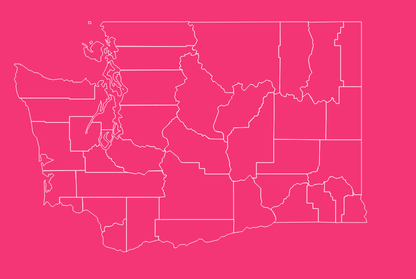
With 39 distinct counties, each with its own local government, tax regulations, and unique history, having access to a reliable Washington county map is essential for professionals, travelers, and residents alike.
How to Use the Interactive Map Tool
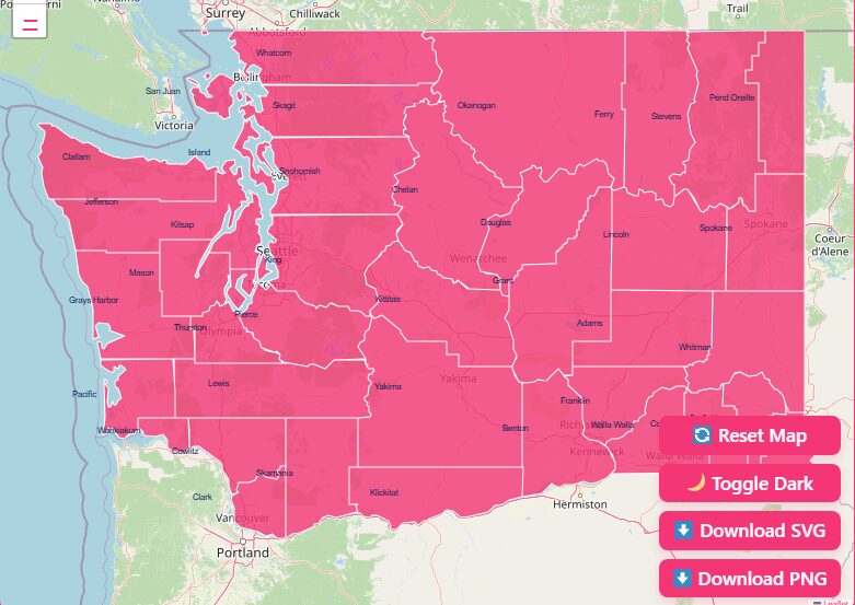
Visualization Controls
Hover Highlight
Simply move your mouse cursor over a specific region. The tool will highlight the county borders and display a popup with the county name and key data points.
Zoom and Pan
Use the + and – buttons (usually in the corner) or the scroll wheel on your mouse to zoom in for street-level detail or zoom out for a state-wide perspective.
Reset View
If you get lost in the details, look for a “Home” or “Reset” icon to instantly return to the default view of the entire state.
Dark Mode Toggle
Many users prefer a dark background for better contrast when viewing bright boundary lines.
Download Options: Printable and Digital Map
PNG (Portable Network Graphics)
Ideal for digital presentations (like PowerPoint) or websites. These images usually come with a transparent background or solid white fill.
SVG (Scalable Vector Graphics)
The preferred format for graphic designers. SVGs allow you to edit individual county shapes, change colors, and resize the map infinitely without losing quality.
Geographical Overview of Washington Counties
To understand the map of Washington, you must understand the “Cascade Curtain.” The Cascade Mountain Range splits the state vertically, creating two distinct geographical and political environments.
Western Washington
The counties west of the Cascades (including King, Pierce, Snohomish, and Thurston) are characterized by a marine climate, dense forests, and high population density.
- Key Feature: This region contains the majority of the state’s population centers and industries, including aerospace and technology.
- Geography: Defined by the Puget Sound, islands (Island and San Juan counties), and the Olympic Mountains.
Eastern Washington
The counties east of the Cascades (such as Yakima, Spokane, and Grant) are generally drier, with a landscape defined by rolling hills, farmland, and the Columbia River basin.
- Key Feature: This is the agricultural heart of the state, leading the nation in apple, hop, and cherry production.
- Geography: Defined by the Columbia River, the Palouse hills, and wide-open shrub-steppe terrain.
Historical Overview of County Formation
The map of Washington didn’t always look like this. The formation of these 39 counties is a story of political evolution, starting well before statehood.
The Early Days (1845)
The Provisional Government of Oregon established the first two counties, Vancouver (later renamed Clark) and Lewis, in 1845.
At that time, these counties encompassed vast areas of land that extended far beyond their current borders.
Territorial Expansion (1853-1889)
Rapid growth occurred during the territorial period.
Following the organization of the Washington Territory in 1853, 28 new counties were formed to manage the influx of settlers and the administration of local law.
Statehood and Finalization
Washington became a state in 1889. County formation slowed down significantly after this. The final county to be established was Pend Oreille County in 1911, which was split off from Stevens County.
Stability
Since 1911, the map has remained largely unchanged, aside from a minor border adjustment between Kittitas and Yakima counties in 1970.
Complete List of Washington Counties
Below is a comprehensive table containing all 39 counties in Washington State.
This dataset includes the Federal Information Processing Standard (FIPS) code, which is essential for data processing and census identification, along with the county seat and the year established.
| County Name | FIPS Code | County Seat | Established |
| Adams | 001 | Ritzville | 1883 |
| Asotin | 003 | Asotin | 1883 |
| Benton | 005 | Prosser | 1905 |
| Chelan | 007 | Wenatchee | 1899 |
| Clallam | 009 | Port Angeles | 1854 |
| Clark | 011 | Vancouver | 1845 |
| Columbia | 013 | Dayton | 1875 |
| Cowlitz | 015 | Kelso | 1854 |
| Douglas | 017 | Waterville | 1883 |
| Ferry | 019 | Republic | 1899 |
| Franklin | 021 | Pasco | 1883 |
| Garfield | 023 | Pomeroy | 1881 |
| Grant | 025 | Ephrata | 1909 |
| Grays Harbor | 027 | Montesano | 1854 |
| Island | 029 | Coupeville | 1852 |
| Jefferson | 031 | Port Townsend | 1852 |
| King | 033 | Seattle | 1852 |
| Kitsap | 035 | Port Orchard | 1857 |
| Kittitas | 037 | Ellensburg | 1883 |
| Klickitat | 039 | Goldendale | 1859 |
| Lewis | 041 | Chehalis | 1845 |
| Lincoln | 043 | Davenport | 1883 |
| Mason | 045 | Shelton | 1854 |
| Okanogan | 047 | Okanogan | 1888 |
| Pacific | 049 | South Bend | 1851 |
| Pend Oreille | 051 | Newport | 1911 |
| Pierce | 053 | Tacoma | 1852 |
| San Juan | 055 | Friday Harbor | 1873 |
| Skagit | 057 | Mount Vernon | 1883 |
| Skamania | 059 | Stevenson | 1854 |
| Snohomish | 061 | Everett | 1861 |
| Spokane | 063 | Spokane | 1879 |
| Stevens | 065 | Colville | 1863 |
| Thurston | 067 | Olympia | 1852 |
| Wahkiakum | 069 | Cathlamet | 1854 |
| Walla Walla | 071 | Walla Walla | 1854 |
| Whatcom | 073 | Bellingham | 1854 |
| Whitman | 075 | Colfax | 1871 |
| Yakima | 077 | Yakima | 1865 |
Important Washington County Insights
While the table above provides the raw data, understanding the character of these counties helps bring the map to life.
King County
Home to Seattle, King County is the economic engine of the state. It hosts major tech giants and has a diverse, highly educated workforce. Its strategic location acts as a gateway to Asian markets.
Yakima County
Located in South Central Washington, Yakima County is an agricultural powerhouse. Known for its affordable, sunny lifestyle, it is a global leader in apple production and a burgeoning wine destination.
San Juan County
Comprising an archipelago in the Salish Sea, this county is unique for being water-locked. It relies heavily on tourism, marine research (via the University of Washington), and a skilled local workforce.
Spokane County
Serving as the cultural and medical hub of the “Inland Empire,” Spokane County connects the economies of Eastern Washington and Northern Idaho. It is the second-most populous county in the state.
The Importance of County Data
Why should you care about county lines? The applications of this data extend far beyond simple geography.
Market Analysis for Business
Businesses use county maps to define sales territories.
Because sales tax rates in Washington are destination-based (calculated based on where the buyer receives the product), knowing the exact county jurisdiction is a legal requirement for compliance.
Route Planning and Logistics
Delivery companies often organize distribution nodes by county.
Understanding the road networks managed by county administrations (like the County Road Administration Board) versus state highways is vital for logistics.
Real Estate and Zoning
Property values, property taxes, and school district boundaries are all inextricably linked to county lines.
A home on one side of a county line might have significantly different tax implications than one just a mile away.
Emergency Services
911 dispatch centers and emergency management plans are organized at the county level. Knowing which county you are in determines who answers your call for help.
Frequently Asked Questions
How many counties are in Washington State?
There are exactly 39 counties in Washington State.
Which Washington county is the oldest?
Clark County (originally Vancouver County) and Lewis County were both established in 1845 by the Provisional Government of Oregon, making them the oldest.
Which Washington county was established last?
Pend Oreille County was the last to be formed, established in 1911 from a portion of Stevens County.
Which county is home to the state capital?
Thurston County is home to Olympia, the state capital and the seat of Washington’s state government.
Are there any dry counties in Washington?
No, there are no dry counties in Washington State where the sale of alcohol is completely prohibited, though specific tribal lands or municipalities may have their own regulations.
Do county lines affect sales tax in Washington?
Yes. Washington uses a destination-based sales tax. The total rate includes the state rate plus the local rate, which varies by county and city.
What is the most populous county in Washington?
King County is the most populous, containing Seattle and many of its suburbs.
Explore Washington Today
Ready to dive deeper? Download a high-resolution map or access the official GIS data portals mentioned above to start exploring Washington’s 39 unique counties today.