Utah is a state defined by dramatic landscapes, rapid population growth, and unique political geography.
From the snow-capped Wasatch Mountains to the red rock deserts of the Colorado Plateau, understanding Utah’s layout requires more than a simple outline map.
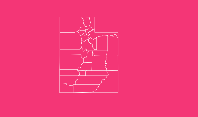
With 29 counties, each serving as a critical unit of local government, a detailed Utah map with counties is essential for researchers, businesses, educators, and residents.
How to Use the Interactive Utah County Map
Our Utah county map is designed to be both intuitive and data-rich, allowing users to explore the state efficiently.
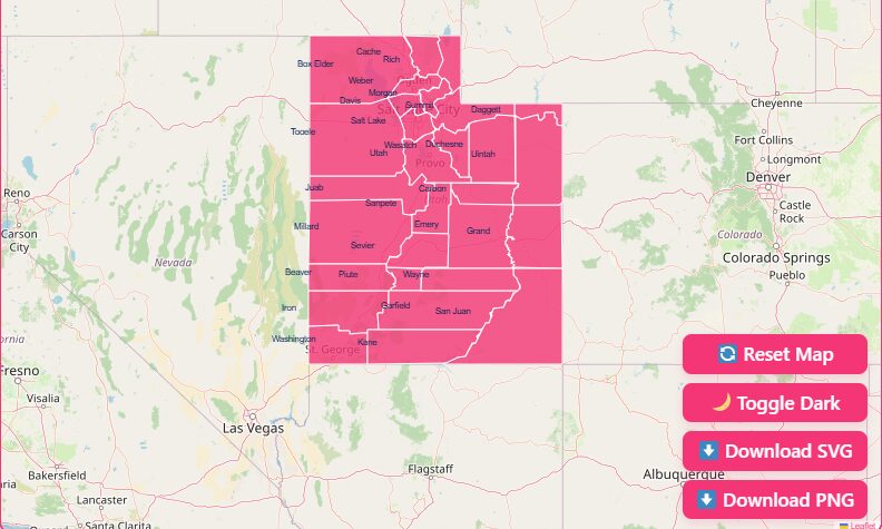
Interactive Map Features
- Hover Highlight
Move your cursor over any county to instantly highlight its boundaries and display the county name and key identifiers. - Zoom In / Zoom Out
Use the + and − controls or your mouse wheel to examine dense areas like Salt Lake County or zoom out for a full statewide view. - Reset View
Instantly return to the default statewide perspective after zooming or panning. - Dark Mode Toggle
Switch to dark mode for improved contrast and reduced eye strain, especially useful for presentations and extended analysis.
Download Options: Printable & Digital Maps
For offline use, presentations, or design work, high-resolution Utah county maps are available in multiple formats:
- SVG (Scalable Vector Graphics)
Ideal for designers and GIS professionals who need editable, infinitely scalable county boundaries. - PNG (High-Resolution Image)
Perfect for reports, websites, and slide decks. - Blank Printable Map
A clean outline of Utah counties for classrooms, quizzes, and custom data plotting.
Geographical Overview of Utah
Utah sits at the crossroads of several major physiographic regions, which strongly influence county size, shape, and population distribution.
The Wasatch Front
This narrow corridor along the western edge of the Wasatch Mountains contains the majority of Utah’s population.
Counties such as Salt Lake, Utah, Davis, and Weber are smaller in land area but densely populated, serving as the state’s economic and political core.
The Colorado Plateau
Covering southern and eastern Utah, this region includes San Juan, Garfield, Kane, and Wayne counties.
These counties are geographically vast, sparsely populated, and defined by canyons, mesas, and national parks.
The Basin and Range Province
Western Utah counties like Tooele, Millard, and Box Elder feature wide valleys separated by rugged mountain ranges, reflecting a more rural and agricultural character.
Historical Overview of Utah County Formation
Utah’s county boundaries reflect the state’s settlement patterns and governance needs during westward expansion.
Early Settlement (1849–1852)
Before Utah became a U.S. territory, Mormon pioneers organized provisional governments. Utah County was created in 1850, followed quickly by other foundational counties to manage land records and local administration.
Territorial Growth
As settlements expanded, especially along water sources and transportation routes, new counties were carved from larger ones.
This explains why eastern and southern counties are significantly larger than those along the Wasatch Front.
Stabilization
By the early 20th century, county formation slowed. Daggett County (1918) was the last county created, finalizing Utah’s current total of 29 counties, a number that has remained unchanged for over a century.
Important Utah County Insights
- Most Populous County: Salt Lake County
Home to Salt Lake City, it is the state’s political, economic, and transportation hub. - Largest County by Area: San Juan County
Covering over 7,800 square miles, it includes vast desert landscapes and portions of Native American reservations. - Smallest County by Area: Davis County
Despite its small size, it is one of the fastest-growing counties due to suburban expansion. - Population Concentration:
Over 80% of Utah’s population lives along the Wasatch Front, while most counties remain predominantly rural.
The Importance of County-Level Data
County boundaries in Utah define far more than geography:
- Government & Jurisdiction:
Law enforcement, courts, and property tax assessments operate at the county level. - FIPS Codes:
Utah’s state FIPS code is 49, with each county assigned a unique three-digit extension (e.g., Utah County = 49049). These codes are critical for census data, emergency management, and federal funding. - Planning & Development:
Infrastructure funding, zoning laws, and school districts depend heavily on county-level statistics.
Complete List of Utah Counties
Below is the full list of all 29 Utah counties, including their FIPS codes, county seats, and establishment years.
| County Name | FIPS Code | County Seat | Established |
| Beaver | 49001 | Beaver | 1856 |
| Box Elder | 49003 | Brigham City | 1856 |
| Cache | 49005 | Logan | 1857 |
| Carbon | 49007 | Price | 1894 |
| Daggett | 49009 | Manila | 1918 |
| Davis | 49011 | Farmington | 1850 |
| Duchesne | 49013 | Duchesne | 1915 |
| Emery | 49015 | Castle Dale | 1880 |
| Garfield | 49017 | Panguitch | 1882 |
| Grand | 49019 | Moab | 1890 |
| Iron | 49021 | Parowan | 1850 |
| Juab | 49023 | Nephi | 1852 |
| Kane | 49025 | Kanab | 1864 |
| Millard | 49027 | Fillmore | 1851 |
| Morgan | 49029 | Morgan | 1862 |
| Piute | 49031 | Junction | 1865 |
| Rich | 49033 | Randolph | 1864 |
| Salt Lake | 49035 | Salt Lake City | 1850 |
| San Juan | 49037 | Monticello | 1880 |
| Sanpete | 49039 | Manti | 1850 |
| Sevier | 49041 | Richfield | 1865 |
| Summit | 49043 | Coalville | 1854 |
| Tooele | 49045 | Tooele | 1850 |
| Uintah | 49047 | Vernal | 1880 |
| Utah | 49049 | Provo | 1850 |
| Wasatch | 49051 | Heber City | 1862 |
| Washington | 49053 | St. George | 1852 |
| Wayne | 49055 | Loa | 1892 |
| Weber | 49057 | Ogden | 1850 |
Frequently Asked Questions
How many counties are in Utah?
Utah has 29 counties.
What is the largest county in Utah?
San Juan County is the largest by land area.
Which county has the highest population?
Salt Lake County is the most populous.
What is Utah’s state FIPS code?
Utah’s state FIPS code is 49.
Which county was formed last?
Daggett County, established in 1918.
Conclusion
Whether you are using the interactive map to explore boundaries or downloading high-resolution files for research, this guide provides a complete and reliable reference to Utah’s counties.
Ready to explore Utah in detail?
Download your free Utah county map and start mapping with confidence.