From the rugged, mist-covered coastline to the high desert plains of the east, Oregon is a state of dramatic contrasts.
Whether you are a real estate investor scouting properties near Portland, a genealogist tracing ancestors along the Oregon Trail, or a student researching the Pacific Northwest, understanding the state’s political boundaries is essential.
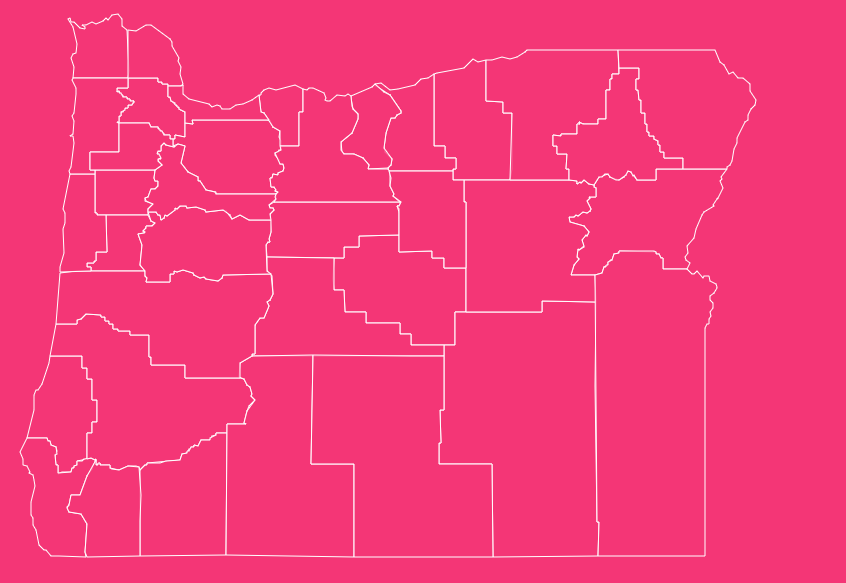
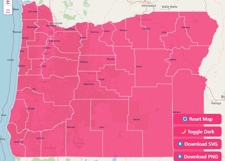
How to Use the Interactive Map Tool
We have designed the map on this page to be as user-friendly and functional as possible.
Whether you need a quick visual reference or a detailed downloadable file for a presentation, this tool adapts to your needs. Here is how to get the most out of it:
Interactive Features
Hover and Highlight
Simply move your mouse cursor (or tap with your finger on mobile) over any section of the map. The specific county will highlight, and a tooltip will appear displaying the county name and seat.
Zoom Capabilities
Need to see the complex boundaries around the Willamette Valley? Use the + and – buttons in the corner of the map, or use your mouse wheel to zoom in and out.
Reset View
If you get lost while zooming in on a specific area, hit the “Reset” button to instantly return to the full state view.
Dark Mode Toggle
Working late or prefer a high-contrast look? Switch the toggle at the top of the map to activate Dark Mode.
Download Options
We understand that sometimes you need a static map for offline use. We offer high-resolution downloads in multiple formats:
SVG (Scalable Vector Graphics)
Best for graphic designers and publishers. You can scale this file to any size without losing quality and edit individual county paths.
PNG (Portable Network Graphics)
Ideal for presentations, documents, and web use. This raster image comes with a transparent background.
Printable PDF
A high-contrast, black-and-white version perfect for classroom handouts or coloring activities.
Historical Overview of County Formation
The map of Oregon has changed drastically over the last 180 years. The story of Oregon’s counties is effectively the story of the state’s settlement and population growth.
The Provisional Government Era (1843–1848)
Before Oregon was a state, or even an official US territory, the Provisional Government of Oregon created the first political districts in 1843. Originally, the massive region was divided into just four districts:
- Twality (later Washington)
- Clackamas
- Yamhill
- Champooick (later Marion)
These “Mother Counties” covered an immense area, extending well into what is now Washington, Idaho, and parts of Montana.
As settlers poured in via the Oregon Trail, these massive districts were subdivided to provide local governance to the booming population.
The Territorial Shift
When the Oregon Territory was officially established in 1848, the legislature began carving out new counties rapidly.
Benton, Linn, and Polk counties were formed to serve the growing agricultural communities in the Willamette Valley.
By the time Oregon achieved statehood in 1859, the western portion of the map looked remarkably similar to how it does today, though the eastern boundaries remained vast and undefined.
The Modern Era
The final adjustments to the Oregon county map were driven by the Homestead Acts and the railroad expansion into the high desert.
The creation of Deschutes County in 1916 marked the final major change to the map.
Split from Crook County, Deschutes was formed to serve the rapidly growing city of Bend, completing the 36-county puzzle we recognize today.
Geographical Overview of Oregon
Understanding the Oregon county map requires understanding the state’s physical geography.
The Cascade Mountain range acts as a spine running north to south, effectively splitting the state into two distinct regions with vastly different county layouts.
Western Oregon: The Population Centers
West of the Cascades, counties tend to be smaller geographically but denser in population.
The Coast
Counties like Clatsop, Tillamook, Lincoln, Coos, and Curry hug the Pacific Ocean. Their economies have historically been driven by fishing, timber, and tourism.
The Willamette Valley
This is the heart of the state. Counties such as Multnomah (Portland), Washington, Clackamas, Marion (Salem), and Lane (Eugene) contain the majority of Oregon’s population.
The boundaries here are tighter, reflecting the density of cities and rich farmland.
Southern Oregon
Jackson and Josephine counties feature rugged terrain and a climate that bridges the wet north and the dry south, famous for fruit orchards and vineyards.
Eastern Oregon: The High Desert
East of the Cascades, the dynamic changes. These counties are enormous.
Harney County
Roughly the size of Massachusetts, Harney is a vast expanse of ranch land, wildlife refuges, and high desert steppes.
Malheur County
In the far southeast, this county is so culturally and economically distinct that it is the only part of Oregon that officially observes Mountain Time (mostly) rather than Pacific Time to align with nearby Boise, Idaho.
The Columbia Plateau
Northern counties like Gilliam, Morrow, and Umatilla are defined by rolling wheat fields and the mighty Columbia River border.
Important Oregon County Insights
When analyzing county data, several interesting trends emerge that are useful for researchers and business owners.
Population Disparity
The disparity between urban and rural counties in Oregon is stark. Multnomah County is the smallest by land area but holds the highest population.
Conversely, Wheeler County often registers as having the lowest population, sometimes dipping below 1,400 residents across its entire territory.
Economic Hubs
- Washington County is often referred to as the “Silicon Forest,” hosting headquarters for giants like Nike and Intel.
- Hood River County is a global leader in pear production and windsurfing tourism.
- Tillamook County is synonymous with dairy production.
Political Boundaries
Because county seats serve as the administrative centers, they are vital for locating courthouses and records.
In many Eastern Oregon counties, the county seat (like Burns in Harney County) serves as the primary commercial hub for a radius of hundreds of miles.
The Importance of County Data
Why is having accurate county map data so critical?
Real Estate and Zoning
Property taxes, school districts, and zoning laws are strictly defined by county lines. A property on the border of Clackamas and Multnomah counties can have significantly different tax liabilities.
Genealogy and History
Vital records (birth, death, marriage) are held at the county level. Knowing that an ancestor lived in “Wasco County” in 1860 is tricky because Wasco County at that time covered half the state.
You need historical context to know which modern county courthouse holds the records.
Business Logistics
For logistics companies, sales territories are often built around FIPS (Federal Information Processing Standards) codes.
These 5-digit codes uniquely identify counties and are essential for census data analysis and targeted marketing.
List of Oregon Counties
The table below provides a complete reference for all 36 counties, including their Federal Information Processing Standards (FIPS) code, current county seat, and the year they were legally established.
| County Name | FIPS Code | County Seat | Established Year |
| Baker | 41001 | Baker City | 1862 |
| Benton | 41003 | Corvallis | 1847 |
| Clackamas | 41005 | Oregon City | 1843 |
| Clatsop | 41007 | Astoria | 1844 |
| Columbia | 41009 | St. Helens | 1854 |
| Coos | 41011 | Coquille | 1853 |
| Crook | 41013 | Prineville | 1882 |
| Curry | 41015 | Gold Beach | 1855 |
| Deschutes | 41017 | Bend | 1916 |
| Douglas | 41019 | Roseburg | 1852 |
| Gilliam | 41021 | Condon | 1885 |
| Grant | 41023 | Canyon City | 1864 |
| Harney | 41025 | Burns | 1889 |
| Hood River | 41027 | Hood River | 1908 |
| Jackson | 41029 | Medford | 1852 |
| Jefferson | 41031 | Madras | 1914 |
| Josephine | 41033 | Grants Pass | 1856 |
| Klamath | 41035 | Klamath Falls | 1882 |
| Lake | 41037 | Lakeview | 1874 |
| Lane | 41039 | Eugene | 1851 |
| Lincoln | 41041 | Newport | 1893 |
| Linn | 41043 | Albany | 1847 |
| Malheur | 41045 | Vale | 1887 |
| Marion | 41047 | Salem | 1843 |
| Morrow | 41049 | Heppner | 1885 |
| Multnomah | 41051 | Portland | 1854 |
| Polk | 41053 | Dallas | 1845 |
| Sherman | 41055 | Moro | 1889 |
| Tillamook | 41057 | Tillamook | 1853 |
| Umatilla | 41059 | Pendleton | 1862 |
| Union | 41061 | La Grande | 1864 |
| Wallowa | 41063 | Enterprise | 1887 |
| Wasco | 41065 | The Dalles | 1854 |
| Washington | 41067 | Hillsboro | 1843 |
| Wheeler | 41069 | Fossil | 1899 |
| Yamhill | 41071 | McMinnville | 1843 |
Frequently Asked Questions
How many counties are there in Oregon?
There are exactly 36 counties in the state of Oregon. This number has remained stable since the formation of Deschutes County in 1916.
Which Oregon county is the largest by land area?
Harney County is the largest, covering approximately 10,226 square miles. It is larger than six different US states.
Which Oregon county is the smallest by land area?
Multnomah County is the smallest, covering roughly 431 square miles. Despite its small size, it is the most densely populated area in the state.
What is the newest county in Oregon?
Deschutes County is the youngest county, established in 1916. It was carved out of the western portion of Crook County.
What were the original four districts of Oregon?
In 1843, the Provisional Government created the districts of Twality (Washington), Clackamas, Yamhill, and Champooick (Marion).
Which county has the highest population?
Multnomah County is the most populous, home to over 800,000 residents and the city of Portland.
Does any Oregon county observe a different time zone?
Yes. Most of Malheur County, located in the southeast corner, observes Mountain Standard Time (MST) due to its economic ties with Boise, Idaho. The rest of the state is on Pacific Standard Time (PST).
Which county is Crater Lake located in?
Crater Lake, the deepest lake in the United States and Oregon’s only National Park, is located in Klamath County.
Where is the state capital located?
The state capital, Salem, is primarily located in Marion County, though a small portion of the city extends across the river into Polk County.
Which county has the smallest population?
Wheeler County consistently has the smallest population, with census data often showing fewer than 1,500 residents.
Navigate Oregon With Confidence
We invite you to use the interactive features on this page to explore the state boundaries in detail. Do not forget to save a copy for your records using the download buttons below.
[Download Free Oregon County Map].