With 100 distinct counties, North Carolina ranks seventh in the nation for the highest number of counties within a single state.
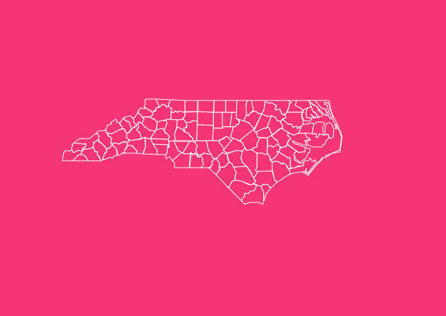
From the crashing waves of the Outer Banks to the misty peaks of the Blue Ridge Mountains, the North Carolina county map is a mosaic of history, geography, and culture.
Navigating this map is about more than just geography; it’s about understanding the state’s DNA.
Whether you are a real estate investor analyzing tax rates, a genealogist hunting for 18th-century marriage bonds, or a traveler planning a road trip along the Blue Ridge Parkway, understanding the layout of these 100 subdivisions is essential.
How to Use the Map Tool on This Page
We have designed our interactive map to be as user-friendly as possible, allowing you to explore the Tar Heel State with ease. Here is how to get the most out of the viewing experience:
Hover and Highlight
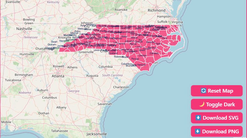
Simply move your mouse cursor over any county on the map. The specific county will highlight, and a tooltip will appear displaying the county name and seat.
Zoom Capabilities
Use the + and – buttons in the top corner of the tool to zoom in on clustered areas, particularly the smaller counties in the Piedmont region.
Reset View
If you get lost in the details, hit the “Reset” button to instantly return to the full state view.
Dark Mode Toggle
Prefer a high-contrast look? Switch the toggle to “Dark Mode” for a sleek interface that reduces eye strain during late-night research sessions.
Download Options
For those who need a static version for presentations, classroom activities, or offline reference, we offer high-resolution downloadable files.
- Printable PNG: Ideal for easy printing and quick reference.
- Scalable SVG: Perfect for graphic designers or publishers who need to resize the map without losing quality.
- Blank Outline Map: A great resource for students and teachers for quizzes or coloring exercises.
Geographical Overview of North Carolina
To understand the county map, you must first understand the three distinct geographical regions that define the state. The 100 counties are distributed across these diverse landscapes.
The Coastal Plain
Covering roughly 45% of the state, the Coastal Plain is the largest region. It is characterized by flat, sandy soil and includes counties like Dare, Hyde, and Carteret.
This area is famous for the Outer Banks and the sound systems that separate the barrier islands from the mainland.
The Piedmont
Located in the central part of the state, the Piedmont (meaning “foot of the mountain”) consists of rolling hills and red clay.
This is the most urbanized region, housing the state’s largest population centers in counties like Wake (Raleigh), Durham, and Mecklenburg (Charlotte).
The Mountains
The western section of the map is dominated by the Appalachian Mountains.
Counties here, such as Buncombe (Asheville) and Watauga (Boone), feature rugged terrain, high elevations, and some of the most scenic drives in America.
Historical Overview of County Formation
The current map of North Carolina took over 240 years to finalize. The story begins in 1668 with the formation of Albemarle County, the state’s first county.
As settlers moved westward from the coast, large counties were divided into smaller ones to ensure citizens didn’t have to travel more than a day to reach their county seat.
This fragmentation continued for centuries. The map was finally completed in 1911, with the creation of Avery and Hoke counties, bringing the total to the nice, round number of 100.
The “Lost” Counties
Not every county that was drawn on the map survived. History buffs should note several defunct counties that no longer exist:
- Albemarle County: Extinct by 1689.
- Bath County: Extinct after 1724.
- Bute County: Divided into Franklin and Warren counties in 1779.
- Dobbs County: Abolished in 1791.
- Tryon County: A name often seen in colonial records, this county was divided into Lincoln and Rutherford counties in 1779.
Additionally, three counties Washington, Sullivan, and Davidson were formed in the late 1700s but were ceded to the federal government in 1790 and are now part of Tennessee.
Important North Carolina County Insights
When analyzing the data, several trends and facts stand out that emphasize the diversity of the state.
Population Centers
The population is heavily concentrated in the Piedmont region along the I-85 and I-40 corridors. Mecklenburg and Wake counties serve as the primary economic engines.
FIPS Codes
The Federal Information Processing Standard (FIPS) code for North Carolina is 37. Each county has a unique three-digit code following this prefix (e.g., Alamance is 37001).
Record Keeping
Because county boundaries shifted so frequently between 1664 and 1911, genealogical researchers must pay close attention to the date of a record.
A birth record from 1750 might be found in a parent county’s archive rather than the current county’s registry.
List of North Carolina Counties
Below is a detailed list of counties, including their Federal Information Processing Standard (FIPS) codes and county seats.
| County Name | FIPS Code | County Seat | Established* |
| Alamance | 37001 | Graham | 1849 |
| Alexander | 37003 | Taylorsville | 1847 |
| Alleghany | 37005 | Sparta | 1859 |
| Anson | 37007 | Wadesboro | 1750 |
| Ashe | 37009 | Jefferson | 1799 |
| Avery | 37011 | Newland | 1911 |
| Beaufort | 37013 | Washington | 1712 |
| Bertie | 37015 | Windsor | 1722 |
| Bladen | 37017 | Elizabethtown | 1734 |
| Brunswick | 37019 | Bolivia | 1764 |
| Buncombe | 37021 | Asheville | 1791 |
| Burke | 37023 | Morganton | 1777 |
| Cabarrus | 37025 | Concord | 1792 |
| Caldwell | 37027 | Lenoir | 1841 |
| Camden | 37029 | Camden | 1777 |
| Carteret | 37031 | Beaufort | 1722 |
| Caswell | 37033 | Yanceyville | 1777 |
| Catawba | 37035 | Newton | 1842 |
| Chatham | 37037 | Pittsboro | 1771 |
| Cherokee | 37039 | Murphy | 1839 |
| Chowan | 37041 | Edenton | 1668 |
| Clay | 37043 | Hayesville | 1861 |
| Cleveland | 37045 | Shelby | 1841 |
| Columbus | 37047 | Whiteville | 1808 |
| Craven | 37049 | New Bern | 1712 |
| Cumberland | 37051 | Fayetteville | 1754 |
| Currituck | 37053 | Currituck | 1668 |
| Dare | 37055 | Manteo | 1870 |
| Davidson | 37057 | Lexington | 1822 |
| Davie | 37059 | Mocksville | 1836 |
| Duplin | 37061 | Kenansville | 1750 |
| Durham | 37063 | Durham | 1881 |
| Edgecombe | 37065 | Tarboro | 1741 |
| Forsyth | 37067 | Winston-Salem | 1849 |
| Franklin | 37069 | Louisburg | 1779 |
| Gaston | 37071 | Gastonia | 1846 |
| Gates | 37073 | Gatesville | 1779 |
| Graham | 37075 | Robbinsville | 1872 |
| Granville | 37077 | Oxford | 1746 |
| Greene | 37079 | Snow Hill | 1799 |
| Guilford | 37081 | Greensboro | 1771 |
| Halifax | 37083 | Halifax | 1758 |
| Harnett | 37085 | Lillington | 1855 |
| Haywood | 37087 | Waynesville | 1808 |
| Henderson | 37089 | Hendersonville | 1838 |
| Hertford | 37091 | Winton | 1759 |
| Hoke | 37093 | Raeford | 1911 |
| Hyde | 37095 | Swan Quarter | 1712 |
| Iredell | 37097 | Statesville | 1788 |
| Jackson | 37099 | Sylva | 1851 |
| Johnston | 37101 | Smithfield | 1746 |
| Jones | 37103 | Trenton | 1779 |
| Lee | 37105 | Sanford | 1907 |
| Lenoir | 37107 | Kinston | 1791 |
| Lincoln | 37109 | Lincolnton | 1779 |
| Macon | 37113 | Franklin | 1828 |
| Madison | 37115 | Marshall | 1851 |
| Martin | 37117 | Williamston | 1774 |
| McDowell | 37111 | Marion | 1842 |
| Mecklenburg | 37119 | Charlotte | 1762 |
| Mitchell | 37121 | Bakersville | 1861 |
| Montgomery | 37123 | Troy | 1779 |
| Moore | 37125 | Carthage | 1784 |
| Nash | 37127 | Nashville | 1777 |
| New Hanover | 37129 | Wilmington | 1729 |
| Northampton | 37131 | Jackson | 1741 |
| Onslow | 37133 | Jacksonville | 1734 |
| Orange | 37135 | Hillsborough | 1752 |
| Pamlico | 37137 | Bayboro | 1872 |
| Pasquotank | 37139 | Elizabeth City | 1668 |
| Pender | 37141 | Burgaw | 1875 |
| Perquimans | 37143 | Hertford | 1668 |
| Person | 37145 | Roxboro | 1791 |
| Pitt | 37147 | Greenville | 1760 |
| Polk | 37149 | Columbus | 1855 |
| Randolph | 37151 | Asheboro | 1779 |
| Richmond | 37153 | Rockingham | 1779 |
| Robeson | 37155 | Lumberton | 1787 |
| Rockingham | 37157 | Wentworth | 1785 |
| Rowan | 37159 | Salisbury | 1753 |
| Rutherford | 37161 | Rutherfordton | 1779 |
| Sampson | 37163 | Clinton | 1784 |
| Scotland | 37165 | Laurinburg | 1899 |
| Stanly | 37167 | Albemarle | 1841 |
| Stokes | 37169 | Danbury | 1789 |
| Surry | 37171 | Dobson | 1771 |
| Swain | 37173 | Bryson City | 1871 |
| Transylvania | 37175 | Brevard | 1861 |
| Tyrrell | 37177 | Columbia | 1729 |
| Union | 37179 | Monroe | 1842 |
| Vance | 37181 | Henderson | 1881 |
| Wake | 37183 | Raleigh | 1771 |
| Warren | 37185 | Warrenton | 1779 |
| Washington | 37187 | Plymouth | 1799 |
| Watauga | 37189 | Boone | 1849 |
| Wayne | 37191 | Goldsboro | 1779 |
| Wilkes | 37193 | Wilkesboro | 1777 |
| Wilson | 37195 | Wilson | 1855 |
| Yadkin | 37197 | Yadkinville | 1850 |
| Yancey | 37199 | Burnsville | 1833 |
Frequently Asked Questions
How many counties does North Carolina have?
North Carolina has exactly 100 counties. This number was finalized in 1911 and places the state 7th in the U.S. for the total number of counties.
What was the first county formed in North Carolina?
Albemarle County was the first, established in 1664 (sometimes cited as 1668 for operational governance). It was later divided and eventually became defunct.
What were the last counties to be created?
Avery County and Hoke County were both created in 1911, marking the end of county formation in the state.
What is the NC state FIPS code?
The Federal Information Processing Standard code for North Carolina is 37. All county codes start with 37 followed by a three-digit identifier (e.g., 37001).
Are there any “extinct” counties in NC?
Yes, several. Notable defunct counties include Albemarle, Bath, Bute, Dobbs, and Tryon. Their records are often dispersed among the counties that were formed from their territory.
Which NC counties are now part of Tennessee?
Washington, Sullivan, and Davidson counties were originally part of North Carolina’s western territory but became part of Tennessee when it was formed.
What is the county seat of Wake County?
The county seat of Wake County is Raleigh, which also serves as the state capital.
Where can I find demographic data for these counties?
For detailed population and economic stats, the US Census Bureau and the North Carolina Office of State Budget and Management (OSBM) are authoritative resources.
Explore North Carolina Today
Ready to dive deeper? Download your high-resolution map now or contact our research team for specific data sets.