Nebraska is often defined by its vast, open landscapes and agricultural heart, but a closer look at its political geography reveals a fascinating patchwork of 93 distinct counties.
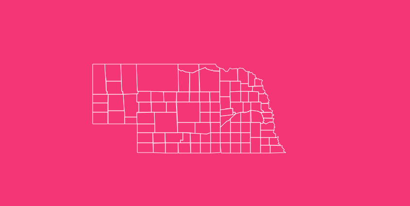
From the urban bustle of Douglas County to the sprawling, sparsely populated sandhills of Cherry County, understanding how these counties fit together is essential for researchers, travelers, and business planners alike.
Whether you are tracking genealogy, planning a logistics route, or simply studying state geography, having access to accurate map data is crucial.
How to Use the Interactive Nebraska Map Tool
Hover to Highlight
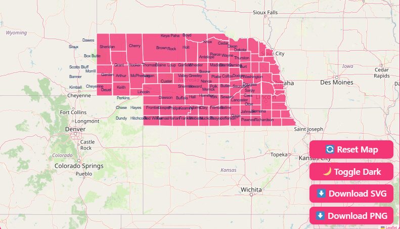
Simply move your cursor over any area of the map to instantly highlight specific counties. This feature allows you to quickly identify county names and their relative locations without clicking through multiple pages.
Zoom Capabilities
Need a closer look at the smaller eastern counties? Use the Zoom In (+) and Zoom Out (-) buttons located in the corner of the map interface.
You can also scroll with your mouse wheel to adjust the view level, making it easy to navigate between a statewide overview and a detailed regional perspective.
Reset Function
If you have zoomed in too far or lost your orientation, hit the Reset button. This will instantly return the map to its original, full-state view, ensuring you never lose your place.
Dark Mode Toggle
For those working late nights or simply preferring a high-contrast aesthetic, we offer a Dark Mode toggle.
This feature inverts the color scheme, reducing eye strain and making boundary lines pop against a dark background, perfect for presentations or prolonged study sessions.
Flexible Download Options
We understand that different projects require different file formats. Below the interactive tool, you will find options to download the map in high-resolution formats:
SVG (Scalable Vector Graphics)
Best for graphic designers and publishers who need to resize the map without losing quality.
PNG (Portable Network Graphics)
Ideal for quick sharing, social media posts, or inserting into Word documents and slide decks.
The Historical Evolution of Nebraska’s Counties
The map of Nebraska wasn’t always the 93-county grid we recognize today.
The state’s internal boundaries have shifted dramatically since the territory opened to settlement, reflecting the turbulent and rapid expansion of the American West.
The Original Eight
In 1854, the Nebraska Territory was created by the Kansas-Nebraska Act.
Shortly after, the first eight counties were established along the Missouri River, serving as the primary entry points for settlers. These original counties were:
- Burt
- Washington
- Douglas
- Dodge
- Cass
- Pierce
- Forney (later renamed Nemaha)
- Richardson
The “Paper” Counties
Between 1866 and 1875, mapmakers and legislators often worked with incomplete information.
This led to the creation of “paper counties”, jurisdictions that existed on legislative bills or maps but never had a functional local government or significant population.
Historical records indicate the existence of six such counties Lyon, Taylor, Monroe, Harrison, Jackson, and Grant which appeared on maps during this period but were eventually dissolved or absorbed into neighboring counties.
It serves as a reminder that early cartography was often as much about aspiration as it was about accurate geography.
Why 93 Counties?
You might wonder why a state with a population of roughly 2 million needs 93 separate counties. The answer lies in the transportation limitations of the 19th century.
County lines were often drawn so that residents could travel to the county seat (to pay taxes or settle legal disputes) and return home within a single day by horse and buggy.
This logic created the dense cluster of small counties in the east, where the population was concentrated, compared to the massive counties in the west, which were formed later as the population spread.
Geographic Overview: More Than Just Flat Land
While often stereotyped as flat farmland, Nebraska’s geography is surprisingly diverse, and this diversity is reflected in its county maps.
The state is generally divided into two major land regions: the Dissected Till Plains and the Great Plains.
The Dissected Till Plains
Covering the eastern fifth of the state, this region was formed by glaciers during the Ice Age.
It features rolling hills and rich soil, making it the agricultural powerhouse of the state. Counties here, such as Lancaster and Sarpy, are smaller in land area but densely populated.
The Great Plains
The rest of the state falls into the Great Plains, which rises in elevation as you travel west toward the foothills of the Rocky Mountains.
Within this region lies the Sand Hills, a unique geological formation covering nearly 20,000 square miles (roughly one-fourth of the state).
Counties in the Sand Hills, like Cherry County, are massive. In fact, Cherry County alone covers nearly 6,000 square miles, making it larger than the entire state of Connecticut.
However, because the sandy soil is better suited for ranching than farming, these counties remain some of the least distinct populated areas in the country.
Important Nebraska County Insights
When analyzing county data, several extremes stand out that highlight the contrast between urban and rural Nebraska.
Population Extremes
Most Populous
Douglas County, home to Omaha, boasts a population of over 600,000 residents. It is the cultural and economic hub of the state.
Least Populous
McPherson County often holds the title for the least populated county, with fewer than 400 residents. This creates a unique “frontier” dynamic where neighbors are miles apart.
Geographic Giants vs. Small Jurisdictions
Largest Area
As mentioned, Cherry County dominates the map in the north-central region. Its size presents unique challenges for infrastructure maintenance and emergency services.
Smallest Area
Sarpy County, located just south of Omaha, is the smallest by land area (only 241 square miles) but is one of the fastest-growing regions due to suburban expansion.
Economic Hubs
While agriculture drives the economy in rural counties (corn, soybeans, and cattle), the counties containing Lincoln (Lancaster) and Omaha (Douglas) function as the corporate and political centers.
Understanding these economic zones is vital for businesses looking to target specific demographics within the state.
The Importance of Accurate County Data
Why does precise county data matter? Beyond trivia, this information is critical for various sectors:
Logistics and Shipping
Delivery companies rely on FIPS (Federal Information Processing Standards) codes to ensure packages reach the correct tax jurisdictions.
Public Policy
State funding for schools, roads, and emergency services is often allocated based on county-level census data.
Real Estate
Property values and tax rates vary significantly across county lines, making accurate maps essential for developers and homebuyers.
Genealogy
Historical researchers use county formation dates to track down birth and marriage records, as records often moved as county boundaries shifted.
Complete List of Nebraska Counties
Below is a complete table of all 93 Nebraska counties, including their FIPS codes, county seats, and the year they were established.
This data is essential for cross-referencing records and ensuring accurate data entry.
| County Name | FIPS Code | County Seat | Established Year |
| Adams | 31001 | Hastings | 1867 |
| Antelope | 31003 | Neligh | 1871 |
| Arthur | 31005 | Arthur | 1913 |
| Banner | 31007 | Harrisburg | 1888 |
| Blaine | 31009 | Brewster | 1885 |
| Boone | 31011 | Albion | 1871 |
| Box Butte | 31013 | Alliance | 1887 |
| Boyd | 31015 | Butte | 1891 |
| Brown | 31017 | Ainsworth | 1883 |
| Buffalo | 31019 | Kearney | 1855 |
| Burt | 31021 | Tekamah | 1854 |
| Butler | 31023 | David City | 1856 |
| Cass | 31025 | Plattsmouth | 1854 |
| Cedar | 31027 | Hartington | 1857 |
| Chase | 31029 | Imperial | 1873 |
| Cherry | 31031 | Valentine | 1883 |
| Cheyenne | 31033 | Sidney | 1867 |
| Clay | 31035 | Clay Center | 1856 |
| Colfax | 31037 | Schuyler | 1869 |
| Cuming | 31039 | West Point | 1855 |
| Custer | 31041 | Broken Bow | 1877 |
| Dakota | 31043 | Dakota City | 1855 |
| Dawes | 31045 | Chadron | 1885 |
| Dawson | 31047 | Lexington | 1860 |
| Deuel | 31049 | Chappell | 1888 |
| Dixon | 31051 | Ponca | 1856 |
| Dodge | 31053 | Fremont | 1854 |
| Douglas | 31055 | Omaha | 1854 |
| Dundy | 31057 | Benkelman | 1873 |
| Fillmore | 31059 | Geneva | 1856 |
| Franklin | 31061 | Franklin | 1867 |
| Frontier | 31063 | Stockville | 1872 |
| Furnas | 31065 | Beaver City | 1873 |
| Gage | 31067 | Beatrice | 1855 |
| Garden | 31069 | Oshkosh | 1909 |
| Garfield | 31071 | Burwell | 1884 |
| Gosper | 31073 | Elwood | 1873 |
| Grant | 31075 | Hyannis | 1887 |
| Greeley | 31077 | Greeley | 1871 |
| Hall | 31079 | Grand Island | 1858 |
| Hamilton | 31081 | Aurora | 1867 |
| Harlan | 31083 | Alma | 1871 |
| Hayes | 31085 | Hayes Center | 1877 |
| Hitchcock | 31087 | Trenton | 1873 |
| Holt | 31089 | O’Neill | 1876 |
| Hooker | 31091 | Mullen | 1889 |
| Howard | 31093 | St. Paul | 1871 |
| Jefferson | 31095 | Fairbury | 1856 |
| Johnson | 31097 | Tecumseh | 1857 |
| Kearney | 31099 | Minden | 1860 |
| Keith | 31101 | Ogallala | 1873 |
| Keya Paha | 31103 | Springview | 1884 |
| Kimball | 31105 | Kimball | 1888 |
| Knox | 31107 | Center | 1857 |
| Lancaster | 31109 | Lincoln | 1855 |
| Lincoln | 31111 | North Platte | 1860 |
| Logan | 31113 | Stapleton | 1885 |
| Loup | 31115 | Taylor | 1883 |
| Madison | 31119 | Madison | 1856 |
| McPherson | 31117 | Tryon | 1887 |
| Merrick | 31121 | Central City | 1858 |
| Morrill | 31123 | Bridgeport | 1908 |
| Nance | 31125 | Fullerton | 1879 |
| Nemaha | 31127 | Auburn | 1854 |
| Nuckolls | 31129 | Nelson | 1860 |
| Otoe | 31131 | Nebraska City | 1854 |
| Pawnee | 31133 | Pawnee City | 1855 |
| Perkins | 31135 | Grant | 1887 |
| Phelps | 31137 | Holdrege | 1873 |
| Pierce | 31139 | Pierce | 1856 |
| Platte | 31141 | Columbus | 1856 |
| Polk | 31143 | Osceola | 1856 |
| Red Willow | 31145 | McCook | 1873 |
| Richardson | 31147 | Falls City | 1854 |
| Rock | 31149 | Bassett | 1888 |
| Saline | 31151 | Wilber | 1867 |
| Sarpy | 31153 | Papillion | 1857 |
| Saunders | 31155 | Wahoo | 1856 |
| Scotts Bluff | 31157 | Gering | 1888 |
| Seward | 31159 | Seward | 1855 |
| Sheridan | 31161 | Rushville | 1885 |
| Sherman | 31163 | Loup City | 1873 |
| Sioux | 31165 | Harrison | 1877 |
| Stanton | 31167 | Stanton | 1855 |
| Thayer | 31169 | Hebron | 1871 |
| Thomas | 31171 | Thedford | 1887 |
| Thurston | 31173 | Pender | 1889 |
| Valley | 31175 | Ord | 1871 |
| Washington | 31177 | Blair | 1854 |
| Wayne | 31179 | Wayne | 1867 |
| Webster | 31181 | Red Cloud | 1871 |
| Wheeler | 31183 | Bartlett | 1877 |
| York | 31185 | York | 1855 |
Frequently Asked Questions
How many counties are in Nebraska?
Nebraska is divided into 93 counties. This is a relatively high number given the state’s population size, ranking it among the top states for total number of counties.
What is the FIPS state code for Nebraska?
The Federal Information Processing Standard (FIPS) state code for Nebraska is 31. When combined with the 3-digit county code, this creates a unique 5-digit identifier for data processing.
Which Nebraska county has the largest land area?
Cherry County is the largest, covering approximately 5,961 square miles. It is significantly larger than the combined area of Rhode Island and Delaware.
Which Nebraska county has the smallest land area?
Sarpy County is the smallest in terms of land mass, spanning just 241 square miles. Despite its size, it is a major suburban hub.
What was the first county established in Nebraska?
The “Original Eight” counties were all established in 1854. These included Burt, Washington, Douglas, Dodge, Cass, Pierce, Forney (Nemaha), and Richardson.
Why are there so many counties in Nebraska?
The high number of counties was originally designed to ensure that any citizen could travel to their county seat and back within a single day on horseback or by wagon.
Is there a map of extinct Nebraska counties?
Yes, historical maps show several counties that no longer exist or were never formally organized, such as Lyon, Taylor, and Monroe counties, which appeared on maps between 1866 and 1875.
What represents the center of Nebraska geographically?
The geographic center of Nebraska is located in Custer County, approximately 10 miles northwest of the town of Broken Bow.
Do all Nebraska counties issue their own license plates?
Historically, Nebraska license plates used a number prefix (1-93) based on the county’s vehicle registration count in 1922. While the system has modernized, these county numbers are still widely recognized by locals (e.g., 1 for Douglas, 2 for Lancaster).
Start Mapping Your Project Today
Don’t settle for low-resolution images or incomplete data sets. Download your free, high-quality Nebraska county map today and get the clarity you need for your next project.
[Download Free Nebraska Map].