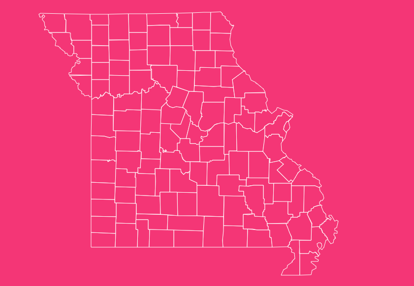
Missouri, often called the “Show-Me State,” boasts a complex and fascinating geography defined by its 114 counties and one independent city.
Whether you are tracing family genealogy, planning a logistics route across the Midwest, or simply organizing a road trip through the Ozarks, understanding the layout of these counties is essential.
Geographical Overview of Missouri
Understanding the map requires understanding the land itself.
Missouri is bordered by eight different states, tied with Tennessee for the most neighbors in the U.S. which makes its border counties economically and culturally distinct.
Northern Plains
Counties north of the Missouri River are largely agricultural, characterized by rolling hills and fertile soil.
The Ozarks
The southern half of the state (excluding the Bootheel) is rugged, forested, and karstic, home to counties with lower population densities and tourism-driven economies.
The Bootheel
The southeastern corner is flat and low-lying, distinct from the rest of the state, with an economy heavily rooted in cotton and rice farming.
Historical Overview of County Formation
Missouri’s county map has evolved significantly since the early 19th century.
Boundaries were set during periods of settlement, often determined by the distance a resident could travel by horse to the county seat and back in a single day.
The St. Louis Anomaly
One of the most confusing aspects of the Missouri map for outsiders is the distinction between St. Louis County and the City of St. Louis.
The Great Divorce (1876)
St. Louis City voted to separate from St. Louis County to avoid financing county infrastructure.
Current Status
Today, they are two entirely separate legal entities. St. Louis City operates as an independent city, functioning at the same administrative level as a county.
It is the smallest “county equivalent” by area in the state.
How to Use the Interactive Tool on This Page
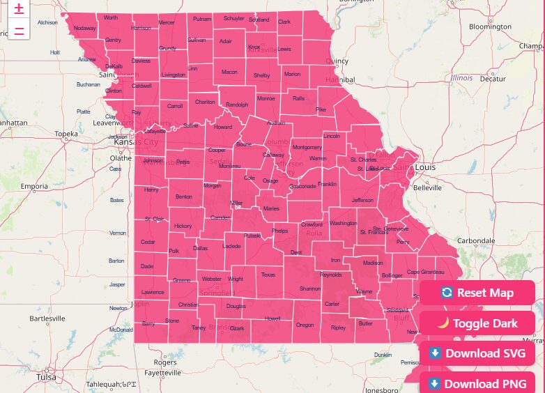
We have designed an interactive map experience to help you visualize data effectively. Here is how to get the most out of the tool:
1. Hover and Highlight
Move your cursor over any area of the map. The tool will instantly highlight the specific county borders and display a tooltip with the county name.
This helps distinguish small counties that are clustered together.
2. Zoom Capabilities
Need a closer look? Use the + and – buttons or scroll with your mouse wheel to zoom in on complex areas, particularly around the metropolitan hubs of Kansas City and St. Louis.
3. Dark Mode Toggle
For better visibility in low-light environments, or simply for a sleeker aesthetic, switch the “Dark Mode” toggle.
4. Reset Button
If you have zoomed in too far or lost your orientation, simply hit the “Reset” button to return the map to its default statewide view.
5. Download Options
We provide high-resolution files suitable for any project:
SVG (Scalable Vector Graphics)
Best for designers and publishers. You can scale this file infinitely without losing quality, making it perfect for large posters or editing in software like Adobe Illustrator.
PNG (Portable Network Graphics)
A high-quality image file with a transparent background, ideal for inserting into PowerPoint presentations, Word documents, or reports.
List of Missouri Counties
Below is a data table featuring key details for Missouri’s counties. Note that Missouri has 114 counties plus one independent city.
| County / City | Full FIPS Code | County Seat | Established | Area (sq mi) |
| Adair | 29001 | Kirksville | 1841 | 569 |
| Andrew | 29003 | Savannah | 1841 | 436 |
| Atchison | 29005 | Rock Port | 1843 | 550 |
| Audrain | 29007 | Mexico | 1831 | 697 |
| Barry | 29009 | Cassville | 1835 | 791 |
| Barton | 29011 | Lamar | 1855 | 597 |
| Bates | 29013 | Butler | 1841 | 851 |
| Benton | 29015 | Warsaw | 1835 | 752 |
| Bollinger | 29017 | Marble Hill | 1851 | 621 |
| Boone | 29019 | Columbia | 1820 | 691 |
| Buchanan | 29021 | St. Joseph | 1838 | 413 |
| Butler | 29023 | Poplar Bluff | 1849 | 699 |
| Caldwell | 29025 | Kingston | 1836 | 430 |
| Callaway | 29027 | Fulton | 1821 | 847 |
| Camden | 29029 | Camdenton | 1841 | 709 |
| Cape Girardeau | 29031 | Jackson | 1812 | 587 |
| Carroll | 29033 | Carrollton | 1833 | 695 |
| Carter | 29035 | Van Buren | 1859 | 508 |
| Cass | 29037 | Harrisonville | 1833 | 699 |
| Cedar | 29039 | Stockton | 1845 | 476 |
| Chariton | 29041 | Keytesville | 1821 | 756 |
| Christian | 29043 | Ozark | 1859 | 563 |
| Clark | 29045 | Kahoka | 1836 | 507 |
| Clay | 29047 | Liberty | 1822 | 396 |
| Clinton | 29049 | Plattsburg | 1833 | 419 |
| Cole | 29051 | Jefferson City | 1820 | 392 |
| Cooper | 29053 | Boonville | 1818 | 565 |
| Crawford | 29055 | Steelville | 1829 | 743 |
| Dade | 29057 | Greenfield | 1841 | 490 |
| Dallas | 29059 | Buffalo | 1841 | 542 |
| Daviess | 29061 | Gallatin | 1836 | 567 |
| DeKalb | 29063 | Maysville | 1843 | 424 |
| Dent | 29065 | Salem | 1851 | 754 |
| Douglas | 29067 | Ava | 1857 | 815 |
| Dunklin | 29069 | Kennett | 1843 | 546 |
| Franklin | 29071 | Union | 1818 | 922 |
| Gasconade | 29073 | Hermann | 1821 | 520 |
| Gentry | 29075 | Albany | 1841 | 492 |
| Greene | 29077 | Springfield | 1833 | 675 |
| Grundy | 29079 | Trenton | 1839 | 436 |
| Harrison | 29081 | Bethany | 1843 | 725 |
| Henry | 29083 | Clinton | 1834 | 702 |
| Hickory | 29085 | Hermitage | 1845 | 399 |
| Holt | 29087 | Oregon | 1841 | 462 |
| Howard | 29089 | Fayette | 1816 | 466 |
| Howell | 29091 | West Plains | 1857 | 928 |
| Iron | 29093 | Ironton | 1857 | 551 |
| Jackson | 29095 | Independence | 1826 | 605 |
| Jasper | 29097 | Carthage | 1841 | 640 |
| Jefferson | 29099 | Hillsboro | 1818 | 657 |
| Johnson | 29101 | Warrensburg | 1834 | 831 |
| Knox | 29103 | Edina | 1843 | 506 |
| Laclede | 29105 | Lebanon | 1849 | 766 |
| Lafayette | 29107 | Lexington | 1821 | 629 |
| Lawrence | 29109 | Mount Vernon | 1843 | 613 |
| Lewis | 29111 | Monticello | 1833 | 505 |
| Lincoln | 29113 | Troy | 1818 | 630 |
| Linn | 29115 | Linneus | 1837 | 620 |
| Livingston | 29117 | Chillicothe | 1837 | 535 |
| McDonald | 29119 | Pineville | 1847 | 540 |
| Macon | 29121 | Macon | 1837 | 804 |
| Madison | 29123 | Fredericktown | 1818 | 497 |
| Maries | 29125 | Vienna | 1855 | 528 |
| Marion | 29127 | Palmyra | 1826 | 438 |
| Mercer | 29129 | Princeton | 1845 | 454 |
| Miller | 29131 | Tuscumbia | 1837 | 592 |
| Mississippi | 29133 | Charleston | 1842 | 413 |
| Moniteau | 29135 | California | 1845 | 417 |
| Monroe | 29137 | Paris | 1831 | 646 |
| Montgomery | 29139 | Montgomery City | 1818 | 539 |
| Morgan | 29141 | Versailles | 1833 | 598 |
| New Madrid | 29143 | New Madrid | 1812 | 678 |
| Newton | 29145 | Neosho | 1838 | 626 |
| Nodaway | 29147 | Maryville | 1843 | 877 |
| Oregon | 29149 | Alton | 1841 | 792 |
| Osage | 29151 | Linn | 1841 | 606 |
| Ozark | 29153 | Gainesville | 1841 | 747 |
| Pemiscot | 29155 | Caruthersville | 1851 | 493 |
| Perry | 29157 | Perryville | 1821 | 475 |
| Pettis | 29159 | Sedalia | 1833 | 685 |
| Phelps | 29161 | Rolla | 1857 | 673 |
| Pike | 29163 | Bowling Green | 1818 | 673 |
| Platte | 29165 | Platte City | 1838 | 420 |
| Polk | 29167 | Bolivar | 1835 | 637 |
| Pulaski | 29169 | Waynesville | 1833 | 547 |
| Putnam | 29171 | Unionville | 1843 | 518 |
| Ralls | 29173 | New London | 1821 | 471 |
| Randolph | 29175 | Huntsville | 1829 | 482 |
| Ray | 29177 | Richmond | 1820 | 570 |
| Reynolds | 29179 | Centerville | 1845 | 811 |
| Ripley | 29181 | Doniphan | 1831 | 630 |
| St. Charles | 29183 | St. Charles | 1812 | 561 |
| St. Clair | 29185 | Osceola | 1841 | 677 |
| Ste. Genevieve | 29186 | Ste. Genevieve | 1812 | 502 |
| St. Francois | 29187 | Farmington | 1821 | 450 |
| St. Louis County | 29189 | Clayton | 1812 | 508 |
| St. Louis City* | 29510 | St. Louis | 1876 | 62 |
| Saline | 29195 | Marshall | 1820 | 756 |
| Schuyler | 29197 | Lancaster | 1843 | 308 |
| Scotland | 29199 | Memphis | 1841 | 438 |
| Scott | 29201 | Benton | 1821 | 426 |
| Shannon | 29203 | Eminence | 1841 | 1,004 |
| Shelby | 29205 | Shelbyville | 1835 | 502 |
| Stoddard | 29207 | Bloomfield | 1835 | 829 |
| Stone | 29209 | Galena | 1851 | 511 |
| Sullivan | 29211 | Milan | 1843 | 652 |
| Taney | 29213 | Forsyth | 1837 | 632 |
| Texas | 29215 | Houston | 1845 | 1,179 |
| Vernon | 29217 | Nevada | 1855 | 837 |
| Warren | 29219 | Warrenton | 1833 | 438 |
| Washington | 29221 | Potosi | 1813 | 762 |
| Wayne | 29223 | Greenville | 1818 | 774 |
| Webster | 29225 | Marshfield | 1855 | 594 |
| Worth | 29227 | Grant City | 1861 | 267 |
| Wright | 29229 | Hartville | 1841 | 683 |
Practical Tips for Using Missouri County Maps
To maximize the utility of these maps, consider the following best practices:
Cross-Reference with Road Maps
County maps often lack detailed road networks. Overlay your county map with a MoDOT highway map for navigation.
Check the Date
Ensure your map is current. While county lines rarely change in modern times, municipal boundaries within them do.
Understand “County Equivalents”
When working with federal data (like Census data), remember that St. Louis City is treated as a county equivalent with its own FIPS code (29510), distinct from St. Louis County (29189).
Case Studies: Real-World Applications
Case Study 1: The Regional Supply Chain
A mid-sized agricultural distributor based in Columbia needed to restructure their delivery zones. By visualizing client density on a county-level map, they realized their drivers were crisscrossing the Missouri River unnecessarily.
They reorganized their territories into “North” and “South” clusters based on county lines, reducing fuel costs by 15%.
Case Study 2: Educational Resource Allocation
A non-profit focused on literacy used a heat map overlaid on Missouri counties. They identified that while Greene County had high resources, neighboring Christian and Webster counties had gaps in library access.
This county-level visualization allowed them to target their mobile library bus routes effectively.
Frequently Asked Questions
How many counties are in Missouri?
Missouri has 114 counties and one independent city (St. Louis), making for 115 county-level administrative units.
What is the largest county in Missouri by area?
Texas County, located in the southern Ozarks, is the largest county by land area, covering approximately 1,179 square miles.
What is the smallest county in Missouri?
Worth County is the smallest by area among the standard counties. However, the independent City of St. Louis is geographically smaller than any county.
Why is St. Louis City not part of St. Louis County?
In 1876, voters approved a separation known as the “Great Divorce.” The city wanted to stop paying for county infrastructure, and the county wanted to distance itself from city politics. They remain separate today.
Which Missouri county has the highest population?
St. Louis County is the most populous. Note that this population count does not include the residents of St. Louis City.
Which county borders the most other states?
This varies by interpretation, but counties in the “Bootheel” (like Pemiscot) and the corners (like McDonald) often border two other states. Missouri itself borders eight different states.
Are detailed road maps included in standard county maps?
Typically, no. A standard county map shows boundaries and seats. For road detail, you need a “General Highway Map” usually provided by the Missouri Department of Transportation (MoDOT).
What is a “County Seat”?
The county seat is the administrative center of the county, housing the courthouse and county government offices. For example, the seat of Cole County is Jefferson City, which is also the state capital.
Conclusion
Ready to explore? Use the interactive features on this page to customize your view, or download a high-resolution map to take with you.