From the fertile plains of the Delta to the sandy shores of the Gulf Coast, Mississippi is a state defined by its diverse geography and rich history.
For researchers, business owners, and travelers alike, understanding the layout of the state is essential.
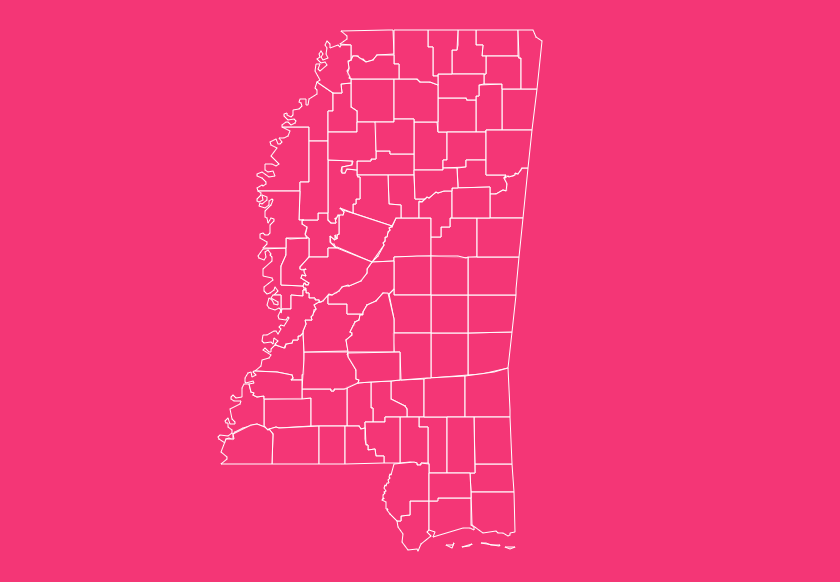
While many people recognize the state by the mighty river that forms its western border, the true administrative heartbeat of Mississippi lies in its 82 counties.
Interactive Mississippi Map Tool
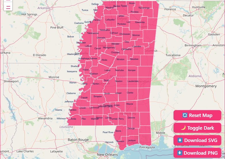
Hover and Highlight
Simply move your mouse cursor over any section of the map. The specific county will highlight, displaying its name and key data points instantly.
Zoom Capabilities
Need a closer look at the smaller counties in the northeast? Use the + and – buttons or scroll with your mouse to zoom in and out for a detailed view of border lines.
Reset View
If you have zoomed in too far or lost your orientation, click the “Reset” button to immediately return to the full state view.
Dark Mode Toggle
For those working late or preferring high-contrast visuals, use the toggle switch to flip the map into dark mode, which changes the background and border colors for easier viewing.
Free Download Options
We believe map data should be accessible. At the bottom of this page, you can access high-resolution downloads of the Mississippi map with counties.
- Printable PDF: Ideal for classrooms and office presentations.
- SVG (Scalable Vector Graphics): Perfect for graphic designers who need to edit the map without losing quality.
- PNG: A standard image format for easy sharing and web use.
Geographical Overview of Mississippi
Mississippi is located in the Deep South, bordered by Tennessee to the north, Alabama to the east, and Arkansas and Louisiana to the west. The southern tip of the state meets the Gulf of Mexico, providing crucial port access.
The state is physically divided into two main regions: the Delta (the northwest section between the Mississippi and Yazoo rivers) and the Hills (the rest of the state).
The county lines often reflect these natural boundaries. For example, the western border of the state is defined entirely by the winding path of the Mississippi River, giving the western counties their irregular, jagged edges.
Historical Overview of County Formation
The history of Mississippi’s counties mirrors the history of the United States’ expansion. Understanding when and how these counties were formed provides context to the map.
The Origins (1799)
The first administrative districts were created well before Mississippi achieved statehood in 1817.
Adams County and Pickering (later renamed Jefferson County) were established in 1799 to govern the Mississippi Territory.
The Expansion
As settlers moved inward from the river and the coast, new counties were carved out of Native American territories (Chickasaw and Choctaw cessions).
This is why many counties, such as Pontotoc, Itawamba, and Tishomingo, bear Native American names.
The Final Addition (1916)
The map we recognize today was finalized in 1916 with the creation of Stone County in the southern part of the state. Since then, the number of counties has remained stable at 82.
Important Mississippi County Insights
When analyzing the Mississippi map with counties, several unique statistical and administrative facts stand out.
Population and Size Extremes
The distribution of land and people is not even across the state.
- Largest by Area: Yazoo County covers approximately 920 square miles, making it the most expansive county in the state.
- Smallest by Area: Alcorn County, tucked in the northeast corner, is the smallest at roughly 400 square miles.
- Most Populous: Hinds County, home to the state capital of Jackson, holds the highest population.
- Least Populous: Issaquena County often ranks as having the lowest population, with fewer than 1,500 residents.
The Phenomenon of Two County Seats
One of the most unique aspects of Mississippi geography is that several counties have two county seats. This dates back to the days of horse-and-buggy travel.
In counties that were geographically long or intersected by difficult terrain (like rivers or swamps), the state established two judicial districts to ensure residents could reach a courthouse within a day’s ride.
The counties with two seats include:
- Bolivar (Cleveland and Rosedale)
- Chickasaw (Houston and Okolona)
- Jasper (Bay Springs and Paulding)
- Panola (Batesville and Sardis)
- Tallahatchie (Charleston and Sumner)
- Yalobusha (Coffeeville and Water Valley)
The Importance of County Data
Why is this map data critical? In Mississippi, the county is the primary unit of local government.
Unlike New England states where towns hold significant power, or western states with massive unincorporated areas, Mississippi counties handle the majority of administrative duties.
For business owners, FIPS (Federal Information Processing Standards) codes are vital for tax reporting and census data analysis.
Logistics companies use these boundaries to determine jurisdiction for road weight limits and permits.
Genealogists rely on county seat locations because that is where marriage, land, and probate records are physically stored.
Complete List of Mississippi Counties
The following table provides a comprehensive dataset for all 82 counties.
It includes the standard FIPS code (prefix 28 for Mississippi), the county seat, and the year the county was established.
| County Name | FIPS Code | County Seat(s) | Established |
| Adams | 28001 | Natchez | 1799 |
| Alcorn | 28003 | Corinth | 1870 |
| Amite | 28005 | Liberty | 1809 |
| Attala | 28007 | Kosciusko | 1833 |
| Benton | 28009 | Ashland | 1870 |
| Bolivar | 28011 | Cleveland, Rosedale | 1836 |
| Calhoun | 28013 | Pittsboro | 1852 |
| Carroll | 28015 | Carrollton, Vaiden | 1833 |
| Chickasaw | 28017 | Houston, Okolona | 1836 |
| Choctaw | 28019 | Ackerman | 1833 |
| Claiborne | 28021 | Port Gibson | 1802 |
| Clarke | 28023 | Quitman | 1833 |
| Clay | 28025 | West Point | 1871 |
| Coahoma | 28027 | Clarksdale | 1836 |
| Copiah | 28029 | Hazlehurst | 1823 |
| Covington | 28031 | Collins | 1819 |
| DeSoto | 28033 | Hernando | 1836 |
| Forrest | 28035 | Hattiesburg | 1908 |
| Franklin | 28037 | Meadville | 1809 |
| George | 28039 | Lucedale | 1910 |
| Greene | 28041 | Leakesville | 1811 |
| Grenada | 28043 | Grenada | 1870 |
| Hancock | 28045 | Bay St. Louis | 1812 |
| Harrison | 28047 | Gulfport, Biloxi | 1841 |
| Hinds | 28049 | Jackson, Raymond | 1821 |
| Holmes | 28051 | Lexington | 1833 |
| Humphreys | 28053 | Belzoni | 1918 |
| Issaquena | 28055 | Mayersville | 1844 |
| Itawamba | 28057 | Fulton | 1836 |
| Jackson | 28059 | Pascagoula | 1812 |
| Jasper | 28061 | Bay Springs, Paulding | 1833 |
| Jefferson | 28063 | Fayette | 1799 |
| Jefferson Davis | 28065 | Prentiss | 1906 |
| Jones | 28067 | Laurel, Ellisville | 1826 |
| Kemper | 28069 | De Kalb | 1833 |
| Lafayette | 28071 | Oxford | 1836 |
| Lamar | 28073 | Purvis | 1904 |
| Lauderdale | 28075 | Meridian | 1833 |
| Lawrence | 28077 | Monticello | 1814 |
| Leake | 28079 | Carthage | 1833 |
| Lee | 28081 | Tupelo | 1866 |
| Leflore | 28083 | Greenwood | 1871 |
| Lincoln | 28085 | Brookhaven | 1870 |
| Lowndes | 28087 | Columbus | 1830 |
| Madison | 28089 | Canton | 1828 |
| Marion | 28091 | Columbia | 1811 |
| Marshall | 28093 | Holly Springs | 1836 |
| Monroe | 28095 | Aberdeen | 1821 |
| Montgomery | 28097 | Winona | 1871 |
| Neshoba | 28099 | Philadelphia | 1833 |
| Newton | 28101 | Decatur | 1836 |
| Noxubee | 28103 | Macon | 1833 |
| Oktibbeha | 28105 | Starkville | 1833 |
| Panola | 28107 | Batesville, Sardis | 1836 |
| Pearl River | 28109 | Poplarville | 1890 |
| Perry | 28111 | New Augusta | 1820 |
| Pike | 28113 | Magnolia | 1815 |
| Pontotoc | 28115 | Pontotoc | 1836 |
| Prentiss | 28117 | Booneville | 1870 |
| Quitman | 28119 | Marks | 1877 |
| Rankin | 28121 | Brandon | 1828 |
| Scott | 28123 | Forest | 1833 |
| Sharkey | 28125 | Rolling Fork | 1876 |
| Simpson | 28127 | Mendenhall | 1824 |
| Smith | 28129 | Raleigh | 1833 |
| Stone | 28131 | Wiggins | 1916 |
| Sunflower | 28133 | Indianola | 1844 |
| Tallahatchie | 28135 | Charleston, Sumner | 1833 |
| Tate | 28137 | Senatobia | 1873 |
| Tippah | 28139 | Ripley | 1836 |
| Tishomingo | 28141 | Iuka | 1836 |
| Tunica | 28143 | Tunica | 1836 |
| Union | 28145 | New Albany | 1870 |
| Walthall | 28147 | Tylertown | 1912 |
| Warren | 28149 | Vicksburg | 1809 |
| Washington | 28151 | Greenville | 1827 |
| Wayne | 28153 | Waynesboro | 1809 |
| Webster | 28155 | Walthall | 1874 |
| Wilkinson | 28157 | Woodville | 1802 |
| Winston | 28159 | Louisville | 1833 |
| Yalobusha | 28161 | Water Valley, Coffeeville | 1833 |
| Yazoo | 28163 | Yazoo City | 1823 |
Frequently Asked Questions
How many counties are in Mississippi?
There are exactly 82 counties in Mississippi.
Which is the largest county in Mississippi by area?
Yazoo County is the largest, covering approximately 920 square miles.
Which is the smallest county in Mississippi?
Alcorn County is the smallest by land area, occupying about 400 square miles.
Which Mississippi county has the largest population?
Hinds County, which contains the state capital of Jackson, is the most populous.
What is the FIPS code prefix for Mississippi counties?
The state code is 28. Therefore, all county FIPS codes begin with 28 (e.g., Adams County is 28001).
Which was the first county established in Mississippi?
Adams County was established in 1799, nearly two decades before Mississippi became a state.
Which was the last county formed in Mississippi?
Stone County was the final county added to the map, established in 1916.
Why do some Mississippi counties have two county seats?
Historically, difficult terrain (swamps and rivers) made travel difficult. To ensure citizens could reach court, the state created two judicial districts within single counties like Bolivar and Panola.
Which counties are on the Mississippi Gulf Coast?
The three counties that border the Gulf of Mexico are Hancock, Harrison, and Jackson.
Where can I find the official records for a specific county?
Official land, tax, and court records are held at the County Courthouse in the designated county seat listed in the table above.
Get Your Free Mississippi Map Today
Ready to use this data for your next project? Click the button below to access your free downloadable maps and start exploring the Magnolia State today.
[Download Free Mississippi Map].