Minnesota is a state defined by its vast diversity, stretching from the rugged cliffs of Lake Superior in the northeast to the rolling prairies of the southwest.
To truly understand the “Land of 10,000 Lakes,” you have to look closer at how it is organized. While outsiders might only know the Twin Cities, the real heart of the state beats across its 87 distinct counties.
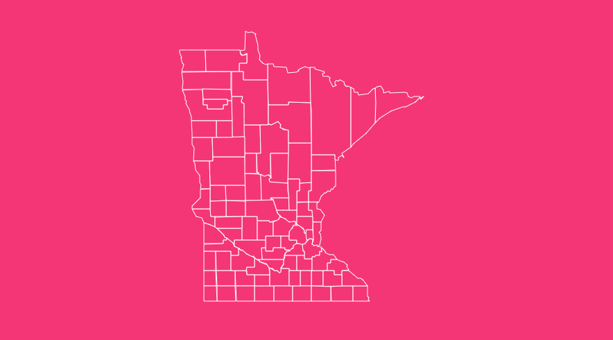
Whether you are a student researching state geography, a business owner analyzing regional data, or a traveler planning a road trip through the Driftless Area, having access to a reliable Minnesota county map is essential.
But a simple image isn’t always enough. You need context, historical data, and the ability to interact with the information.
How to Use the Tool on This Page
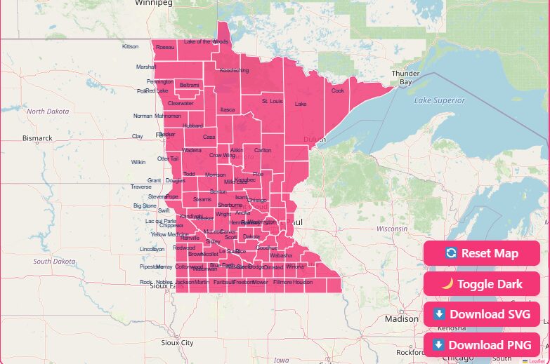
Navigating complex geographic data should be simple. Our interactive map tool is designed to give you immediate access to the information you need without clutter.
Here is how you can get the most out of the viewing experience:
Hover Highlight
Simply move your mouse (or tap on mobile) over any specific county. The map will instantly highlight the border of that county, separating it from its neighbors for clear visibility.
Zoom In and Out
Use the + and – buttons (or scroll wheel) to zoom in for a granular view and zoom out to see the full state context.
Reset Button
If you have zoomed in too far or lost your orientation, hit the “Reset” button to instantly snap the map back to the default statewide view.
Dark Mode Toggle
For easier viewing in low-light environments, or simply to make the county borders pop against a high-contrast background, toggle the Dark Mode switch.
Download Options
We understand that sometimes you need a map you can take with you, print out for a classroom, or use in a professional presentation.
We offer several high-quality download formats for the Minnesota county map.
Blank Printable Map
Perfect for educational settings, quizzes, or manual data entry. This version removes all labels, leaving just the crisp outline of the 87 counties.
- Best for: Teachers, students, and coloring activities.
SVG (Scalable Vector Graphics)
For graphic designers and publishers, the SVG format ensures that lines remain sharp no matter how much you resize the image. You can edit individual county shapes in software like Adobe Illustrator.
- Best for: Web design, print publications, and professional presentations.
PNG Image
A standard, high-resolution image file that works with almost any software, from Microsoft Word to Google Slides.
- Best for: Quick sharing, email attachments, and document insertion.
Historical Overview of County Formation
The map of Minnesota looked very different in the mid-19th century. The organization of the state’s counties is a story of rapid expansion, political maneuvering, and population growth.
The Original Nine
On October 27, 1849, the Minnesota Territory legislature established the first nine counties. While some of these names are familiar, their boundaries were massive compared to today:
- Benton
- Dahkotah (Later Dakota)
- Itasca
- Ramsey
- Mahkahta (Dissolved)
- Pembina (Renamed Kittson)
- Wabasha
- Washington
- Wahnata (Dissolved)
Statehood and Expansion
By the time Minnesota was granted statehood in 1858, the map was filling in rapidly. 57 of the current 87 counties were already established.
The drive to organize counties was fueled by the need for local governance as settlers moved westward and northward.
The Final Piece
The county map as we know it today wasn’t finalized until the 20th century. The very last county to be formed was Lake of the Woods County, created in 1923.
It was carved out of the northern portion of Beltrami County, largely due to the geographic isolation of the area.
Geographical Overview of Minnesota
Minnesota’s counties are not just political lines; they encompass four distinct ecological provinces (biomes) that make the state geographically unique.
The Arrowhead and North Woods
Counties in the northeast, such as St. Louis, Lake, and Cook, are part of the Canadian Shield. This area is defined by:
- Dense pine forests
- Rocky terrain and cliffs
- Thousands of lakes (including the Boundary Waters)
- Iron ore deposits
The Driftless Area
In the southeast, counties like Houston, Fillmore, and Winona lie in the “Driftless Zone.” This region escaped the flattening effects of the last glaciers. Consequently, the geography features:
- Deep river valleys
- Limestone bluffs
- Trout streams
- Cave systems
The Prairie Pothole Region
Moving to the west and southwest, counties like Nobles, Pipestone, and Rock are characterized by:
- Rolling plains
- Rich agricultural soil
- Wind farms (Buffalo Ridge)
- Open horizons
The Transition Zone
A diagonal band of counties stretching from the southeast to the northwest acts as a transition zone.
This includes the “Big Woods”, once a vast deciduous forest, now largely replaced by agriculture and suburban development, notably in Hennepin and Wright counties.
Important Minnesota County Insights
When analyzing the map, certain counties stand out due to their statistical outliers. Here are key insights to keep in mind:
Largest County by Area
St. Louis County is massive. Covering approximately 6,860 square miles, it is larger than the entire states of Connecticut and Rhode Island combined.
Smallest County by Area
Ramsey County, home to the state capital (St. Paul), is the most geographically compact, covering roughly 170 square miles.
Most Populous
Hennepin County dominates the population charts, home to Minneapolis and over 1.2 million residents.
Least Populous
Traverse County, located on the western border, consistently ranks as one of the least populated, often with fewer than 3,500 residents.
Newest County
As mentioned in the history section, Lake of the Woods (1923) is the youngest county on the map.
The Importance of County Data
Why does county-level data matter? In Minnesota, counties serve as the primary administrative arm of the state government.
They are responsible for essential services that affect daily life. Understanding county boundaries helps you understand:
- Social Services: Delivery of welfare, child protection, and mental health services.
- Infrastructure: Maintenance of County State-Aid Highways (CSAH) and rural roads.
- Elections: Management of polling places and vote tabulation.
- Law Enforcement: The Sheriff’s office and county attorney jurisdictions.
- Property Records: Recording of land titles, deeds, and vital statistics.
List of Minnesota Counties
The following table provides a complete reference for all 87 counties in Minnesota.
It includes the Federal Information Processing Standard (FIPS) code, which is vital for data analysis, the county seat (administrative center), and the year the county was established.
| County Name | FIPS Code | County Seat | Established |
| Aitkin County | 001 | Aitkin | 1857 |
| Anoka County | 003 | Anoka | 1857 |
| Becker County | 005 | Detroit Lakes | 1858 |
| Beltrami County | 007 | Bemidji | 1866 |
| Benton County | 009 | Foley | 1849 |
| Big Stone County | 011 | Ortonville | 1862 |
| Blue Earth County | 013 | Mankato | 1853 |
| Brown County | 015 | New Ulm | 1855 |
| Carlton County | 017 | Carlton | 1857 |
| Carver County | 019 | Chaska | 1855 |
| Cass County | 021 | Walker | 1851 |
| Chippewa County | 023 | Montevideo | 1870 |
| Chisago County | 025 | Center City | 1851 |
| Clay County | 027 | Moorhead | 1862 |
| Clearwater County | 029 | Bagley | 1902 |
| Cook County | 031 | Grand Marais | 1874 |
| Cottonwood County | 033 | Windom | 1857 |
| Crow Wing County | 035 | Brainerd | 1857 |
| Dakota County | 037 | Hastings | 1849 |
| Dodge County | 039 | Mantorville | 1855 |
| Douglas County | 041 | Alexandria | 1858 |
| Faribault County | 043 | Blue Earth | 1855 |
| Fillmore County | 045 | Preston | 1853 |
| Freeborn County | 047 | Albert Lea | 1855 |
| Goodhue County | 049 | Red Wing | 1853 |
| Grant County | 051 | Elbow Lake | 1868 |
| Hennepin County | 053 | Minneapolis | 1852 |
| Houston County | 055 | Caledonia | 1854 |
| Hubbard County | 057 | Park Rapids | 1883 |
| Isanti County | 059 | Cambridge | 1857 |
| Itasca County | 061 | Grand Rapids | 1849 |
| Jackson County | 063 | Jackson | 1857 |
| Kanabec County | 065 | Mora | 1858 |
| Kandiyohi County | 067 | Willmar | 1858 |
| Kittson County | 069 | Hallock | 1878 |
| Koochiching County | 071 | International Falls | 1906 |
| Lac qui Parle County | 073 | Madison | 1871 |
| Lake County | 075 | Two Harbors | 1856 |
| Lake of the Woods County | 077 | Baudette | 1923 |
| Le Sueur County | 079 | Le Center | 1853 |
| Lincoln County | 081 | Ivanhoe | 1873 |
| Lyon County | 083 | Marshall | 1871 |
| McLeod County | 085 | Glencoe | 1856 |
| Mahnomen County | 087 | Mahnomen | 1906 |
| Marshall County | 089 | Warren | 1879 |
| Martin County | 091 | Fairmont | 1857 |
| Meeker County | 093 | Litchfield | 1856 |
| Mille Lacs County | 095 | Milaca | 1857 |
| Morrison County | 097 | Little Falls | 1856 |
| Mower County | 099 | Austin | 1855 |
| Murray County | 101 | Slayton | 1857 |
| Nicollet County | 103 | St. Peter | 1853 |
| Nobles County | 105 | Worthington | 1857 |
| Norman County | 107 | Ada | 1881 |
| Olmsted County | 109 | Rochester | 1855 |
| Otter Tail County | 111 | Fergus Falls | 1858 |
| Pennington County | 113 | Thief River Falls | 1910 |
| Pine County | 115 | Pine City | 1856 |
| Pipestone County | 117 | Pipestone | 1857 |
| Polk County | 119 | Crookston | 1858 |
| Pope County | 121 | Glenwood | 1862 |
| Ramsey County | 123 | Saint Paul | 1849 |
| Red Lake County | 125 | Red Lake Falls | 1896 |
| Redwood County | 127 | Redwood Falls | 1862 |
| Renville County | 129 | Olivia | 1855 |
| Rice County | 131 | Faribault | 1853 |
| Rock County | 133 | Luverne | 1857 |
| Roseau County | 135 | Roseau | 1894 |
| St. Louis County | 137 | Duluth | 1855 |
| Scott County | 139 | Shakopee | 1853 |
| Sherburne County | 141 | Elk River | 1856 |
| Sibley County | 143 | Gaylord | 1853 |
| Stearns County | 145 | St. Cloud | 1855 |
| Steele County | 147 | Owatonna | 1855 |
| Stevens County | 149 | Morris | 1862 |
| Swift County | 151 | Benson | 1870 |
| Todd County | 153 | Long Prairie | 1855 |
| Traverse County | 155 | Wheaton | 1862 |
| Wabasha County | 157 | Wabasha | 1849 |
| Wadena County | 159 | Wadena | 1858 |
| Waseca County | 161 | Waseca | 1857 |
| Washington County | 163 | Stillwater | 1849 |
| Watonwan County | 165 | St. James | 1860 |
| Wilkin County | 167 | Breckenridge | 1858 |
| Winona County | 169 | Winona | 1854 |
| Wright County | 171 | Buffalo | 1855 |
| Yellow Medicine County | 173 | Granite Falls | 1871 |
Frequently Asked Questions
How many counties are in Minnesota?
There are 87 counties in Minnesota. This number has remained stable since the final county, Lake of the Woods, was established in 1923.
Which Minnesota county has the largest population?
Hennepin County is the most populous, containing Minneapolis and many of its suburbs. It is the economic and cultural hub of the state.
Which Minnesota county is the largest by area?
St. Louis County is the largest by land area, covering the northeastern part of the state, including Duluth and the Iron Range.
What is the newest county in Minnesota?
Lake of the Woods County is the newest county, established on November 28, 1923. It was created to provide better local governance for residents separated from the Beltrami county seat by dense forests and peat bogs.
Which county is home to the state capital?
Ramsey County is home to Saint Paul, the capital city of Minnesota.
Are there any counties named after Native American tribes?
Yes, many. For example, Dakota, Chisago, Chippewa, and Mahnomen counties all derive their names from the Dakota or Ojibwe languages and tribes.
Why does Minnesota have so many counties?
Like many midwestern states, county lines were often drawn so that a resident could travel by horse and buggy to the county seat and back in a single day.
This resulted in smaller, more numerous counties in the southern agricultural part of the state compared to the larger, forested northern counties.
What is the “Northwest Angle”?
The Northwest Angle is the northernmost point of the contiguous United States. It is part of Lake of the Woods County and is separated from the rest of the US by the lake, making it accessible by land only through Canada.
Can I print the map on this page for my classroom?
Yes! Please utilize the “Download Options” section above to download a high-resolution, blank Printable Map specifically designed for educational use.