If you look at a map of the United States, Michigan is perhaps the most recognizable state of all. Shaped like a mitten and split into two distinct peninsulas, the “Great Lakes State” is a geographical marvel.
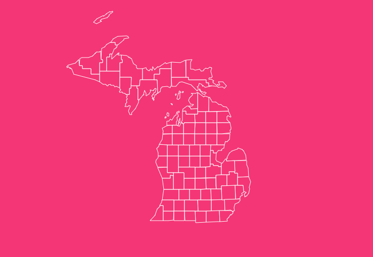
But beyond its iconic shape lies a complex grid of 83 counties, each with its own unique history, seat of government, and identity.
From the urban sprawl of Wayne County to the rugged, forested wilderness of Marquette County in the Upper Peninsula, understanding Michigan’s layout is essential for residents, researchers, and visitors alike.
How to Use the Tool on This Page
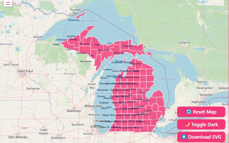
Hover Highlight
Simply move your mouse cursor (or tap with your finger on mobile) over any specific county. The map will instantly highlight the borders of that county and display a tooltip with the county name.
Zoom In / Out
Detailed analysis often requires a closer look. Use the + and – buttons located in the top corner of the map interface to zoom in on complex areas, such as the cluster of counties around the Detroit metropolitan area.
Dark Mode Toggle
If you are working late or prefer a high-contrast viewing experience, switch the toggle to “Dark Mode.”
Reset Button
Got lost in the zoom? Hit the “Reset” button to instantly snap the map back to the full state view, showing both the Upper and Lower Peninsulas.
Download Options
Printable SVG (Scalable Vector Graphics)
This format is perfect for graphic designers or publishers. Because it is a vector file, you can scale the map to the size of a billboard without losing any image quality.
It is also editable in software like Adobe Illustrator.
High-Resolution PNG
Ideal for slide decks, homework assignments, or quick reference. This format features a transparent background, allowing you to drop the map onto any document easily.
Geographical Overview of Michigan
Michigan’s geography is distinct in North America because it is the only state consisting of two major peninsulas.
The Lower Peninsula, shaped like a mitten, is where the majority of the population resides.
It is characterized by flat to rolling terrain, fertile agricultural land in the south, and sandy dunes along the western coast.
The Upper Peninsula (often called “the U.P.”) is separated from the Lower Peninsula by the Straits of Mackinac.
It is geologically older, rockier, and heavily forested. The western portion of the U.P., particularly around the Porcupine Mountains, features the highest elevations in the state.
Crucially, the county lines are dictated by the water. Michigan borders four Great Lakes: Superior, Michigan, Huron, and Erie.
This results in the state having the longest freshwater coastline of any political subdivision in the world.
Forty of the 83 counties border at least one of the Great Lakes, significantly influencing their economies, weather patterns, and tourism industries.
Historical Overview of County Formation
The boundaries you see today were not drawn overnight. Michigan’s county formation is a story of political maneuvering and expansion during the 19th century.
In the early 1800s, much of the Michigan Territory was unorganized wilderness. The first counties, such as Wayne (established in 1815), were massive, covering vast swathes of land that would eventually be carved up into smaller jurisdictions.
As settlers moved northward and westward, the territorial legislature defined new boundaries.
A fascinating period in this history occurred in 1840 when the state legislature created a large number of counties in the northern Lower Peninsula and the Upper Peninsula.
Many of these were originally given Native American names. However, in a wave of political reshaping in 1843, many were renamed to honor Irish counties (like Antrim, Wexford, and Roscommon) or political figures.
The map stabilized significantly by 1897. Since the creation of Dickinson County in 1891, the county boundaries have remained largely unchanged, providing over a century of geographical stability.
Important Michigan County Insights
When analyzing the map, a few counties stand out for their statistical or geographical significance:
Largest County
Marquette County in the Upper Peninsula is the largest by land area, covering approximately 1,808 square miles.
Smallest County
Benzie County is the smallest by land area, comprising just 321 square miles.
Most Populous
Wayne County, home to Detroit, is the most populous, containing a significant percentage of the state’s total population.
Least Populous
Keweenaw County, located at the very tip of the Upper Peninsula’s Keweenaw Peninsula, often holds the title for the smallest population.
The “Cabinet” Counties
Several counties were named after members of President Andrew Jackson’s cabinet, reflecting the political allegiances of the Michigan Territory leadership at the time (e.g., Eaton, Berrien, Branch, Calhoun)
List of Michigan Counties
Below is the complete data table for all 83 counties in Michigan. The FIPS code (Federal Information Processing Standard) is a unique identifier used by the Census Bureau to track data.
Counties A-G
| County Name | FIPS Code | County Seat | Year Est. |
| Alcona | 001 | Harrisville | 1840 |
| Alger | 003 | Munising | 1885 |
| Allegan | 005 | Allegan | 1831 |
| Alpena | 007 | Alpena | 1840 |
| Antrim | 009 | Bellaire | 1840 |
| Arenac | 011 | Standish | 1831 |
| Baraga | 013 | L’Anse | 1875 |
| Barry | 015 | Hastings | 1829 |
| Bay | 017 | Bay City | 1857 |
| Benzie | 019 | Beulah | 1863 |
| Berrien | 021 | St. Joseph | 1829 |
| Branch | 023 | Coldwater | 1829 |
| Calhoun | 025 | Marshall | 1829 |
| Cass | 027 | Cassopolis | 1829 |
| Charlevoix | 029 | Charlevoix | 1869 |
| Cheboygan | 031 | Cheboygan | 1840 |
| Chippewa | 033 | Sault Ste. Marie | 1827 |
| Clare | 035 | Harrison | 1840 |
| Clinton | 037 | St. Johns | 1831 |
| Crawford | 039 | Grayling | 1840 |
| Delta | 041 | Escanaba | 1843 |
| Dickinson | 043 | Iron Mountain | 1891 |
| Eaton | 045 | Charlotte | 1829 |
| Emmet | 047 | Petoskey | 1840 |
| Genesee | 049 | Flint | 1835 |
| Gladwin | 051 | Gladwin | 1831 |
| Gogebic | 053 | Bessemer | 1887 |
| Grand Traverse | 055 | Traverse City | 1840 |
| Gratiot | 057 | Ithaca | 1831 |
Counties H-M
| County Name | FIPS Code | County Seat | Year Est. |
| Hillsdale | 059 | Hillsdale | 1829 |
| Houghton | 061 | Houghton | 1845 |
| Huron | 063 | Bad Axe | 1840 |
| Ingham | 065 | Mason | 1829 |
| Ionia | 067 | Ionia | 1831 |
| Iosco | 069 | Tawas City | 1840 |
| Iron | 071 | Crystal Falls | 1885 |
| Isabella | 073 | Mt. Pleasant | 1831 |
| Jackson | 075 | Jackson | 1829 |
| Kalamazoo | 077 | Kalamazoo | 1829 |
| Kalkaska | 079 | Kalkaska | 1840 |
| Kent | 081 | Grand Rapids | 1831 |
| Keweenaw | 083 | Eagle River | 1861 |
| Lake | 085 | Baldwin | 1840 |
| Lapeer | 087 | Lapeer | 1822 |
| Leelanau | 089 | Suttons Bay | 1840 |
| Lenawee | 091 | Adrian | 1822 |
| Livingston | 093 | Howell | 1833 |
| Luce | 095 | Newberry | 1887 |
| Mackinac | 097 | St. Ignace | 1818 |
| Macomb | 099 | Mt. Clemens | 1818 |
| Manistee | 101 | Manistee | 1840 |
| Marquette | 103 | Marquette | 1843 |
| Mason | 105 | Ludington | 1840 |
| Mecosta | 107 | Big Rapids | 1840 |
| Menominee | 109 | Menominee | 1861 |
| Midland | 111 | Midland | 1831 |
| Missaukee | 113 | Lake City | 1840 |
| Monroe | 115 | Monroe | 1817 |
| Montcalm | 117 | Stanton | 1831 |
| Montmorency | 119 | Atlanta | 1840 |
| Muskegon | 121 | Muskegon | 1859 |
Counties N-W
| County Name | FIPS Code | County Seat | Year Est. |
| Newaygo | 123 | White Cloud | 1840 |
| Oakland | 125 | Pontiac | 1819 |
| Oceana | 127 | Hart | 1831 |
| Ogemaw | 129 | West Branch | 1840 |
| Ontonagon | 131 | Ontonagon | 1843 |
| Osceola | 133 | Reed City | 1840 |
| Oscoda | 135 | Mio | 1840 |
| Otsego | 137 | Gaylord | 1840 |
| Ottawa | 139 | Grand Haven | 1831 |
| Presque Isle | 141 | Rogers City | 1840 |
| Roscommon | 143 | Roscommon | 1840 |
| Saginaw | 145 | Saginaw | 1822 |
| St. Clair | 147 | Port Huron | 1820 |
| St. Joseph | 149 | Centreville | 1829 |
| Sanilac | 151 | Sandusky | 1822 |
| Schoolcraft | 153 | Manistique | 1843 |
| Shiawassee | 155 | Corunna | 1822 |
| Tuscola | 157 | Caro | 1840 |
| Van Buren | 159 | Paw Paw | 1829 |
| Washtenaw | 161 | Ann Arbor | 1822 |
| Wayne | 163 | Detroit | 1815 |
| Wexford | 165 | Cadillac | 1840 |
Frequently Asked Questions
How many counties are there in Michigan?
There are exactly 83 counties in the state of Michigan.
Which is the largest county in Michigan by area?
Marquette County is the largest by land area, encompassing roughly 1,808 square miles in the Upper Peninsula.
Which Michigan county has the highest population?
Wayne County is the most populous, home to the city of Detroit and over 1.7 million residents.
What was the first county established in Michigan?
Wayne County was the first, established in 1815, even before Michigan formally became a state.
Are there any counties on islands?
While no county consists entirely of a single island without mainland territory, Keweenaw County includes Isle Royale, which is a significant island landmass located in Lake Superior.
Why does Michigan have so many counties with Irish names?
In 1843, legislation was passed to rename several counties. Many were given names of Irish counties (Antrim, Wexford, Clare, Roscommon) to appeal to the increasing number of Irish immigrants and settlers.
Do all Michigan counties observe the same time zone?
No. While most of the state is in the Eastern Time Zone, four counties in the Upper Peninsula (Gogebic, Iron, Dickinson, and Menominee) bordering Wisconsin are in the Central Time Zone.
Which county has the longest coastline?
This is often debated due to the “coastline paradox,” but Chippewa County and Delta County have massive shorelines. However, Keweenaw County has the highest ratio of shoreline to land area.
What is the FIPS code for Michigan?
The state FIPS code for Michigan is 26. A full county FIPS code includes the state code (e.g., Wayne County is 26163).
Can I fly a drone in all Michigan counties?
Drone laws are generally consistent with FAA regulations across counties, but specific local ordinances in county parks (like those in Oakland or Ottawa counties) may restrict takeoff and landing zones. Always check local maps.
Ready to Map Your Project?
Whether you are planning a road trip across the Upper Peninsula or conducting market research in Grand Rapids, having the right data makes all the difference.
If you need help interpreting specific county data or require a more customized mapping solution for your business, contact our team today to see how we can assist you.