From the Appalachian peaks of Garrett County to the sandy dunes of Worcester, Maryland packs incredible diversity into its 24 jurisdictions.
Whether you are a researcher, a student, or a local planning a road trip, understanding the layout of the “Old Line State” is essential.
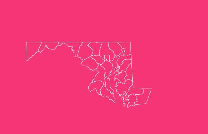
How to Use the Map Tool on This Page
Navigating Maryland’s geography is easier than ever with interactive mapping technology. Here is how to get the most out of the map tool:
Hover Highlight
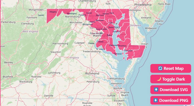
Simply move your mouse over any county to see its border light up. This helps distinguish boundaries in complex areas like the Baltimore metro region.
Zoom In/Out
Use the + and – buttons or scroll with your mouse wheel to get a closer look at smaller counties like Howard or Calvert.
Dark Mode Toggle
Switching to dark mode improves visibility for high-contrast presentations or late-night research.
Reset Button
Lost in the map? Hit “Reset” to instantly return to the full state view.
Download Options
Need a map for a presentation or classroom? You can download the current view as:
Printable Blank Map: Perfect for quizzes and coloring.
SVG (Scalable Vector Graphics): Best for graphic designers needing high-quality edits.
PNG: Ideal for quick insertion into documents and slideshows.
Historical Overview of County Formation
Maryland’s map wasn’t drawn in a day. It evolved over three centuries, reflecting the colony’s growth, political shifts, and economic needs.
The process began in 1637 with the establishment of St. Mary’s County, the first organized jurisdiction.
Named after the mother of Jesus, it served as the colonial capital. As settlers moved north and west, new counties were carved out of old ones.
The Colonial Era (1600s-1700s)
Most counties were established during this period to manage the tobacco economy and legal administration. Significant figures like the Calvert family (Lords Baltimore) heavily influenced naming conventions.
The 19th Century Split
The final boundaries took shape much later. Garrett County was the last to form in 1872, separating from Allegany County due to the unique needs of the western mountain communities.
The City/County Distinction
A crucial quirk in Maryland geography occurred in 1851, when Baltimore City separated from Baltimore County.
Today, Baltimore City functions as an independent entity, a “county-equivalent” for statistical purposes, meaning it has its own court system and government separate from the surrounding county.
Geographical Overview of Maryland
Maryland is often called “America in Miniature” because it possesses nearly every type of topography found in the United States, except for a desert.
The state is divided into five distinct regions, each with a unique culture and landscape.
1. Western Maryland
- Counties: Garrett, Allegany, Washington.
- Landscape: Part of the Appalachian Mountains. Known for rugged terrain, dense forests, and the highest point in the state (Backbone Mountain).
- Vibe: Outdoor adventure, history, and rural charm.
2. Capital Region
- Counties: Frederick, Montgomery, Prince George’s.
- Landscape: Rolling piedmont hills transitioning into the urban corridor.
- Vibe: Bustling, diverse, and heavily influenced by the proximity to Washington, D.C. It is the economic engine of the state.
3. Central Maryland
- Counties: Anne Arundel, Baltimore City, Baltimore County, Carroll, Harford, Howard.
- Landscape: A mix of urban centers, suburban sprawl, and equestrian countryside.
- Vibe: The historic and industrial heart of Maryland, centered around the Chesapeake Bay and the Port of Baltimore.
4. Southern Maryland
- Counties: Calvert, Charles, St. Mary’s.
- Landscape: A peninsula bounded by the Potomac River and the Chesapeake Bay.
- Vibe: Agricultural and maritime heritage mixed with growing commuter communities. Famous for tobacco history and fossil hunting.
5. Eastern Shore
- Counties: Caroline, Cecil, Dorchester, Kent, Queen Anne’s, Somerset, Talbot, Wicomico, Worcester.
- Landscape: Flat coastal plains, marshes, and miles of shoreline.
- Vibe: Relaxed, maritime culture. Known for crabbing, sailing, and Ocean City tourism.
Important Maryland County Insights
When analyzing the Maryland county map, several trends emerge that go beyond simple geography.
Population Density
The disparity in population density is stark. Montgomery and Prince George’s counties are densely packed urban centers with over a million residents combined.
In contrast, Kent County on the Eastern Shore remains largely rural, maintaining a quiet, agricultural lifestyle with a population under 20,000.
Economic Hubs vs. Agricultural Belts
The “I-95 Corridor” running through Central and Capital Maryland contains the vast majority of the state’s jobs and wealth.
Meanwhile, the Eastern Shore and Western Maryland remain vital for the state’s agricultural output, producing poultry, corn, soybeans, and apples.
The Water Connection
Almost every county in Maryland interacts with water.
Whether it is the Atlantic Ocean bordering Worcester, the Chesapeake Bay defining the Eastern Shore and Southern Maryland, or the Potomac River shaping the southern border of the Western and Capital regions, water is the defining feature of the state’s boundaries.
The Importance of County Data
Why does county-level data matter? In Maryland, counties hold significant power. Unlike states with strong township governments, Maryland counties handle the majority of local services, including:
- Public Schools: Managed at the county level (e.g., Montgomery County Public Schools).
- Police and Fire: Primary emergency services are county-based.
- Zoning and Planning: Land use decisions are made by county councils.
Understanding the county map is not just geography, it’s understanding how the state functions politically and socially.
List of Maryland Counties
Below is a comprehensive table detailing Maryland’s 23 counties and 1 independent city, sorted alphabetically.
| County Name | FIPS Code | County Seat | Established |
| Allegany County | 24-001 | Cumberland | 1789 |
| Anne Arundel County | 24-003 | Annapolis | 1650 |
| Baltimore City | 24-510 | Independent City | 1851 |
| Baltimore County | 24-005 | Towson | 1659 |
| Calvert County | 24-009 | Prince Frederick | 1654 |
| Caroline County | 24-011 | Denton | 1773 |
| Carroll County | 24-013 | Westminster | 1837 |
| Cecil County | 24-015 | Elkton | 1674 |
| Charles County | 24-017 | La Plata | 1658 |
| Dorchester County | 24-019 | Cambridge | 1669 |
| Frederick County | 24-021 | Frederick | 1748 |
| Garrett County | 24-023 | Oakland | 1872 |
| Harford County | 24-025 | Bel Air | 1773 |
| Howard County | 24-027 | Ellicott City | 1851 |
| Kent County | 24-029 | Chestertown | 1642 |
| Montgomery County | 24-031 | Rockville | 1776 |
| Prince George’s County | 24-033 | Upper Marlboro | 1696 |
| Queen Anne’s County | 24-035 | Centreville | 1706 |
| Somerset County | 24-039 | Princess Anne | 1666 |
| St. Mary’s County | 24-037 | Leonardtown | 1637 |
| Talbot County | 24-041 | Easton | 1661 |
| Washington County | 24-043 | Hagerstown | 1776 |
| Wicomico County | 24-045 | Salisbury | 1867 |
| Worcester County | 24-047 | Snow Hill | 1742 |
Individual County Profiles
To give you a better sense of the state, here are brief profiles of key Maryland jurisdictions:
Allegany County
- Origin: Native American word Oolikhanna (“Beautiful Stream”).
- Key Landmark: The C&O Canal and Cumberland Narrows.
- Fact: Known as the “Mountain Side of Maryland,” historically a major transportation hub.
Anne Arundel County
- Origin: Named for Lady Anne Arundell, wife of Cecilius Calvert.
- Key Landmark: The Maryland State House (Annapolis).
- Fact: Home to the U.S. Naval Academy and the state capital.
Baltimore City (Independent)
- Origin: Named for the Lords Baltimore.
- Key Landmark: The Inner Harbor and Fort McHenry.
- Fact: Home to Johns Hopkins Hospital and the birthplace of “The Star-Spangled Banner.”
Baltimore County
- Origin: Also named for the proprietary family.
- Key Landmark: Hampton National Historic Site.
- Fact: Wraps around the city like a horseshoe; home to UMBC and Towson University.
Frederick County
- Origin: Named for Frederick Calvert, the 6th Lord Baltimore.
- Key Landmark: Clustered Spires of Frederick.
- Fact: The largest county by land area in Maryland (660 sq miles).
Montgomery County
- Origin: Named for Revolutionary War General Richard Montgomery.
- Key Landmark: Great Falls of the Potomac.
- Fact: The most populous county in Maryland (over 1 million residents).
St. Mary’s County
- Origin: Named in honor of the Virgin Mary.
- Key Landmark: Historic St. Mary’s City.
- Fact: The “Mother County” of Maryland, established first in 1637.
Worcester County
- Origin: Named for the Earl of Worcester.
- Key Landmark: Ocean City Boardwalk and Assateague Island.
- Fact: The only Maryland county that borders the Atlantic Ocean.
Frequently Asked Questions
How many counties are in Maryland?
There are 23 counties plus Baltimore City, which is an independent city that functions as a county equivalent, totaling 24 main jurisdictions.
Which is the largest county in Maryland by area?
Frederick County is the largest by land area, covering approximately 660 square miles.
Which is the smallest county in Maryland?
Howard County is the smallest by land area at just 251 square miles (excluding Baltimore City, which is smaller at roughly 81 square miles).
Why is Baltimore City separate from Baltimore County?
They separated in 1851. The city residents wanted to control their own tax revenues and political destiny separate from the then-rural county.
What is the oldest county in Maryland?
St. Mary’s County was first established in 1637.
What is the newest county in Maryland?
Garrett County was the last to be formed, splitting from Allegany County in 1872.
Which county has the highest population?
Montgomery County is the most populous, followed closely by Prince George’s County.
Is there a “dry” county in Maryland?
No, there are no completely dry counties, though some (like parts of Montgomery and Worcester) have specific liquor control laws or dispensary systems.
What FIPS code does Maryland start with?
Maryland’s state FIPS code is 24. All county codes begin with “24-” followed by a three-digit identifier (e.g., Allegany is 24-001).
Which county is known as the “Heart of the Eastern Shore”?
Dorchester County often holds this title due to its central location on the shore and its unique heart-shaped geography.
Explore Maryland Today
These 24 jurisdictions represent a microcosm of American geography and history. By understanding the boundaries, you understand the diverse communities that make the Old Line State unique.
Ready to dive deeper? Download our high-resolution SVG map or start exploring the interactive tool above to visualize the data for yourself!