Known for its jagged coastline, dense forests, and lobster heritage, Maine is a state defined by its geography.

While it is the largest state in New England, it is administratively divided into just sixteen counties, a surprisingly small number given its vast land area of over 35,000 square miles.
Whether you are a researcher tracing genealogical roots, a traveler planning a road trip up Route 1, or a student of New England history, understanding the layout of Maine’s counties is essential.
Interactive Map of Maine Counties: How to Use the Tool
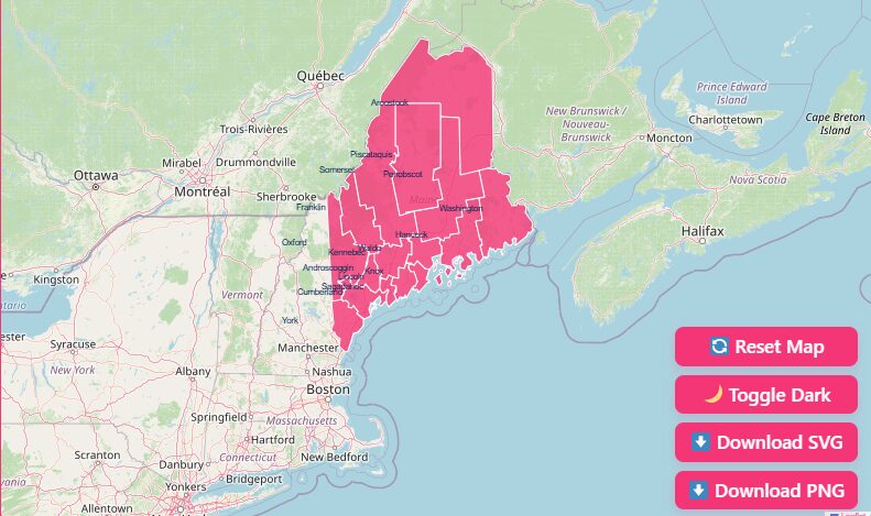
Hover to Highlight
Simply move your mouse cursor over any section of the map. The specific county will highlight, displaying its name and boundary lines clearly against the surrounding areas.
Zoom In and Out
Use the + and – buttons located in the corner of the map interface to zoom in for a closer look at jagged coastal inlets or zoom out to see the state’s relationship to New Hampshire and Canada.
Dark Mode Toggle
If you are viewing this map in low light, switch to Dark Mode using the toggle switch. This inverts the color scheme for easier viewing and reduced eye strain.
Reset View
Got lost in the North Woods? Hit the “Reset” button to instantly return the map to its original, statewide view.
Download Options
Need a map for a presentation or classroom project? You can download high-quality versions of the map directly.
- Download SVG: Best for graphic designers who need an editable vector file.
- Download PNG: Ideal for standard document insertion or printing.
- Printable Blank Map: Perfect for educational quizzes or labeling exercises.
Historical Overview of County Formation
The history of Maine’s counties is inextricably linked to the history of the United States and the border disputes that followed the Revolutionary War.
Unlike many western states that were gridded out with mathematical precision, Maine’s county lines evolved organically through colonial claims and international treaties.
Early Counties Formed Under Massachusetts
It is a common trivia fact that Maine was not one of the original 13 colonies.
Instead, it was a district of Massachusetts. Because of this, nine of Maine’s sixteen counties were established before Maine even became a state.
The First County
York County was the first to be established in 1652. At that time, the Massachusetts Bay Colony laid claim to southern Maine, naming the region Yorkshire.
Expansion Northward
As settlers moved north and east, new counties were carved out of York. Cumberland and Lincoln counties followed in 1760.
By the late 1700s and early 1800s, Hancock, Kennebec, Oxford, Somerset, Penobscot, and Washington counties were all incorporated under Massachusetts law.
Statehood and the Missouri Compromise
The push for Maine’s independence from Massachusetts gained momentum after the War of 1812, where many Mainers felt the Massachusetts government failed to protect them from British occupation in the eastern territories.
On March 15, 1820, Maine was admitted to the Union as the 23rd state.
This admission was part of the Missouri Compromise, a legislative package that allowed Maine to enter as a free state while Missouri entered as a slave state, maintaining the balance of power in Congress.
The Impact of the Webster-Ashburton Treaty
Even after statehood, Maine’s geography wasn’t fully settled. The northern border between Maine and the British colony of New Brunswick (now Canada) was hotly contested.
This friction led to the bloodless “Aroostook War” in 1838-1839.
The dispute was finally resolved in 1842 with the Webster-Ashburton Treaty.
This treaty established the St. John River as the international boundary, finalizing the northern borders of what is now Aroostook County.
Following this treaty, the final shape of Maine was set, and the last distinct counties, Androscoggin, Sagadahoc, and Knox were formed by 1860.
Overview of Maine’s Sixteen Counties
Maine’s counties vary wildly in character. To the south, they are populous and coastal; to the north, they are vast, rural, and forested. Below is a detailed look at each county.
Androscoggin County
- County Seat: Auburn
- Established: 1854
- Highlights: Home to the twin cities of Lewiston and Auburn, this county is an industrial and cultural hub powered by the Androscoggin River. It is the second-smallest county by area but densely populated.
Aroostook County
- County Seat: Houlton
- Established: 1839
- Highlights: Known simply as “The County” to locals, Aroostook is larger than the states of Connecticut and Rhode Island combined. It is famous for its potato farming heritage and immense tracts of wilderness.
Cumberland County
- County Seat: Portland
- Established: 1760
- Highlights: This is the economic engine of the state. Home to Portland, Maine’s largest city, Cumberland County features a mix of historic port districts, suburban growth, and the stunning Casco Bay islands.
Franklin County
- County Seat: Farmington
- Established: 1838
- Highlights: A paradise for outdoor enthusiasts, Franklin County contains varied terrain ranging from the foothills to the High Peaks region, including the Sugarloaf ski resort.
Hancock County
- County Seat: Ellsworth
- Established: 1789
- Highlights: Hancock County is globally famous as the home of Acadia National Park and Mount Desert Island. It features a rugged, dramatic coastline that attracts millions of visitors annually.
Kennebec County
- County Seat: Augusta
- Established: 1799
- Highlights: Centrally located, this county hosts the state capital, Augusta. It is marked by the Kennebec River and the Belgrade Lakes region, offering a blend of government activity and lakeside leisure.
Knox County
- County Seat: Rockland
- Established: 1860
- Highlights: Known for its lobster industry and windjammer fleets, Knox County embodies the quintessential mid-coast Maine aesthetic. Rockland serves as a cultural center with renowned art museums.
Lincoln County
- County Seat: Wiscasset
- Established: 1760
- Highlights: Wiscasset calls itself “The Prettiest Village in Maine,” and the surrounding county supports that claim with charming peninsulas, the Pemaquid Point Light, and Boothbay Harbor.
Oxford County
- County Seat: Paris
- Established: 1805
- Highlights: Bordering New Hampshire, Oxford County is characterized by the White Mountain foothills and Western Maine lakes. It is a hub for skiing (Sunday River) and mineral mining.
Penobscot County
- County Seat: Bangor
- Established: 1816
- Highlights: Anchored by Bangor, once the lumber capital of the world, this county follows the Penobscot River north into the deep woods. It is a gateway to the northern wilderness.
Piscataquis County
- County Seat: Dover-Foxcroft
- Established: 1838
- Highlights: The least populous county in Maine, Piscataquis is home to Baxter State Park and Mount Katahdin, the northern terminus of the Appalachian Trail. It is a haven for wilderness lovers.
Sagadahoc County
- County Seat: Bath
- Established: 1854
- Highlights: The smallest county in Maine by land area, Sagadahoc is defined by its shipbuilding history at Bath Iron Works and the sandy beaches of Reid State Park and Popham Beach.
Somerset County
- County Seat: Skowhegan
- Established: 1809
- Highlights: Stretching from central Maine all the way to the Canadian border, Somerset is known for whitewater rafting on the Kennebec River and vast timberlands.
Waldo County
- County Seat: Belfast
- Established: 1827
- Highlights: Located on the western side of Penobscot Bay, Waldo County is rural and agricultural, with Belfast serving as a vibrant, creative coastal center.
Washington County
- County Seat: Machias
- Established: 1789
- Highlights: Often called the “Sunrise County” because it is the first place in the U.S. to see the sun, this immense, sparsely populated region is famous for wild blueberries and dramatic, foggy cliffs.
York County
- County Seat: Alfred
- Established: 1652
- Highlights: As the southern gateway to Maine, York County features long sandy beaches (Ogunquit, Old Orchard Beach) and historic towns like Kittery and Kennebunkport.
List of Maine Counties Data
For quick reference, here is the administrative data for all sixteen counties, including their Federal Information Processing Standard (FIPS) codes, which are used for census tracking.
| County Name | FIPS Code | County Seat | Established Year |
| Androscoggin | 23001 | Auburn | 1854 |
| Aroostook | 23003 | Houlton | 1839 |
| Cumberland | 23005 | Portland | 1760 |
| Franklin | 23007 | Farmington | 1838 |
| Hancock | 23009 | Ellsworth | 1789 |
| Kennebec | 23011 | Augusta | 1799 |
| Knox | 23013 | Rockland | 1860 |
| Lincoln | 23015 | Wiscasset | 1760 |
| Oxford | 23017 | Paris | 1805 |
| Penobscot | 23019 | Bangor | 1816 |
| Piscataquis | 23021 | Dover-Foxcroft | 1838 |
| Sagadahoc | 23023 | Bath | 1854 |
| Somerset | 23025 | Skowhegan | 1809 |
| Waldo | 23027 | Belfast | 1827 |
| Washington | 23029 | Machias | 1789 |
| York | 23031 | Alfred | 1652 |
The Importance of County Data
Why does looking at Maine through a county map matter?
Genealogy
Vital records (birth, marriage, death) and land deeds are organized by county.
Knowing that your ancestor lived in “Massachusetts” in 1790 might actually mean they lived in what is now Hancock County, Maine.
Real Estate
Property taxes and deed recordings happen at the county registry level.
Emergency Management
While towns handle local police and fire, counties coordinate emergency management agencies (EMA) and run the sheriff’s departments that patrol rural areas.
Census Analysis
FIPS codes allow researchers to track population shifts, such as the growth in Cumberland County versus the decline in Washington County.
Frequently Asked Questions
What is the largest county in Maine by size?
Aroostook County is the largest by land area, covering 6,829 square miles. It is so large that it accounts for 21.6% of the state’s total land mass.
What is the smallest county in Maine?
Sagadahoc County is the smallest by land area, covering only 254 square miles (though total area is larger if you include water).
Which Maine county has the highest population?
Cumberland County is the most populous, home to over 300,000 residents nearly 25% of the state’s total population.
Why does Maine have so few counties?
Compared to states like Georgia (159 counties) or Texas (254 counties), Maine’s 16 seem low.
This is largely due to the “New England Town Model.” In New England, local towns and cities hold the majority of political power and provide most services, making strong county governments less necessary.
Are there any “dry” counties in Maine?
No, there are no dry counties in Maine. However, there are individual “dry towns” where the sale of alcohol is restricted or prohibited.
What was the last county formed in Maine?
Knox County was the last to be incorporated, formed in 1860 from portions of Lincoln and Waldo counties.
Does Maine have counties that border Canada?
Yes, five counties border Canada: Oxford, Franklin, Somerset, Aroostook, and Washington.
What is the FIPS code for Maine?
The state FIPS code for Maine is 23.
Can I record a deed in any county courthouse?
No. You must record land deeds in the Registry of Deeds for the specific county where the property is located.
Note that Aroostook County is unique; it has two registries (Northern District in Fort Kent and Southern District in Houlton).
Is Acadia National Park in a specific county?
Yes, the majority of Acadia National Park is located in Hancock County, with some portions on Isle au Haut in Knox County.
Conclusion
We hope this interactive map and guide help you navigate the rich geography of the Pine Tree State.
Whether you are printing a blank map for a classroom quiz or downloading an SVG for a design project, understanding these boundaries is the first step to truly knowing Maine.
Ready to explore more? Use the tool at the top of the page to download your free Maine County Map today!