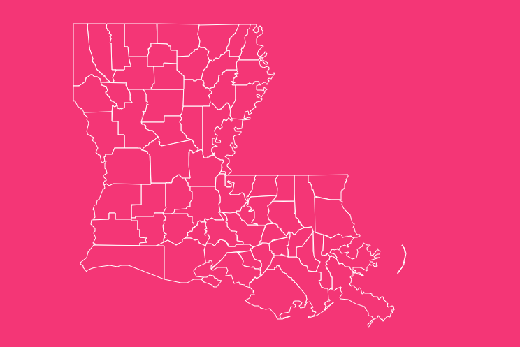
When you look at a map of the United States, you’ll see thousands of counties spread across 50 states. But zoom into the boot-shaped state on the Gulf Coast, and you’ll find something unique. Louisiana doesn’t have counties. It has parishes.
This distinction is more than just a quirky naming convention; it is a direct reflection of the state’s rich French and Spanish colonial history.
Whether you are a student, a researcher, or simply curious about the Pelican State, understanding the layout of these 64 subdivisions is essential to understanding Louisiana itself.
Why Does Louisiana Have Parishes Instead of Counties?
If you travel to any of the other 49 states, local governments are organized into counties. Louisiana stands alone in its use of the term “parish.”
The origin of this terminology dates back to the state’s colonial past. Before the Louisiana Purchase in 1803, the territory was governed first by France and then by Spain.
Both nations were predominantly Roman Catholic. During this time, the region was divided into ecclesiastical districts, church parishes rather than secular administrative districts.
When the territory became a state in 1812, the legislature kept the term “parish” to describe its primary political subdivisions. Today, Louisiana has 64 parishes.
While they function almost identically to counties in other states, managing courts, law enforcement, and infrastructure, the name serves as a lasting reminder of the state’s cultural heritage.
How Do I Use the Interactive Map Tool?
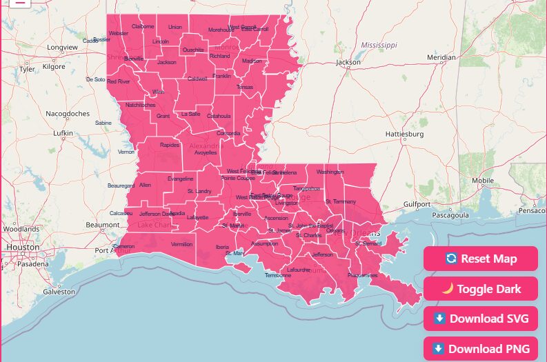
Hover & Highlight
Simply move your cursor over any area of the map. The specific parish will highlight, displaying its name and key data points instantly.
Zoom In & Out
Need a closer look at the intricate coastline or the dense urban areas around New Orleans? Use the + and – buttons or the scroll wheel on your mouse to zoom.
Reset Button
If you have zoomed in too far or lost your orientation, hit the “Reset” button to snap the map back to its original full-state view.
Dark Mode Toggle
Prefer a different aesthetic? Switch between light and dark modes to view the map in the contrast that suits your screen best.
Download Options
Need a map for a presentation or a classroom activity? You can download blank, printable versions of the Louisiana map in both SVG (scalable vector graphics) and PNG formats directly from the toolbar.
What Does the Geography of Louisiana Look Like?
Louisiana’s geography is dominated by water.
The Mississippi River, the defining feature of the North American continent, empties into the Gulf of Mexico here, creating a landscape defined by deltas, marshes, and bayous.
The state is generally divided into two main regions:
The Uplands
Found in the north and parts of the Florida Parishes (east of the Mississippi). This area features rolling hills and pine forests.
Driskill Mountain, the highest point in the state, is located here, though at only 535 feet, it is a modest peak.
The Alluvial Region
Covering the areas along the Mississippi River and the Gulf Coast. This includes the famous wetlands, swamps, and barrier islands.
This geography dictates population centers.
You won’t find major cities in the deep Atchafalaya Swamp; instead, they cluster along the higher ground of the river banks and the solid ground of the northern uplands.
Where Are the Major Cities and Population Centers?
Louisiana’s population is heavily concentrated in urban centers, while many rural parishes remain sparsely populated. According to recent census data, the distribution looks like this:
The Big Three
- New Orleans (Orleans Parish): The cultural heart of the state, famous for Mardi Gras, jazz, and distinct Creole cuisine.
- Baton Rouge (East Baton Rouge Parish): The state capital and a major industrial and educational hub.
- Shreveport (Caddo Parish): The commercial and cultural center of North Louisiana, with closer ties to Texas and Arkansas culture than the Creole south.
Population Shifts
Since 2010, the state has seen shifting demographics. Suburban parishes like St. Tammany and Ascension have seen explosive growth as residents move out of dense urban centers seeking more space.
Conversely, many rural parishes in the Mississippi Delta region have seen population declines due to economic shifts in agriculture.
How Were Louisiana’s Parishes Formed?
The map of Louisiana didn’t always look like it does today. The formation of these 64 parishes was a gradual process spanning over a century.
- 1805: The territory was initially divided into 12 counties.
- 1807: The legislature reverted to the “parish” system, creating 19 original parishes based on existing church boundaries.
- 1812: When Louisiana became a state, more parishes were carved out to accommodate a growing population.
- 1912: The final outlines were drawn. The last three parishes created were Allen, Beauregard, and Jefferson Davis.
Since 1912, the boundaries have remained largely static, providing over 100 years of consistent geographical data.
Why Is County Data Important?
Analyzing data at the parish level is crucial for several industries and interests:
Business & Real Estate
Companies use demographic data to decide where to open new branches or invest in property.
Public Policy
Government officials use parish maps to allocate funds for hurricane relief, infrastructure repair, and school districts.
Genealogy
Family historians use historical parish maps to track the migration of ancestors and locate vital records like birth and marriage certificates.
Education
Teachers use blank maps to help students learn state geography and understand the diverse ecosystems of the region.
Complete List of Louisiana Parishes
Below is a complete table of all 64 parishes, including their FIPS code (a standard identifier used by the Census Bureau), the parish seat (administrative center), and the year the parish was founded.
| Parish Name | FIPS Code | Parish Seat | Established |
| Acadia | 22001 | Crowley | 1886 |
| Allen | 22003 | Oberlin | 1912 |
| Ascension | 22005 | Donaldsonville | 1807 |
| Assumption | 22007 | Napoleonville | 1807 |
| Avoyelles | 22009 | Marksville | 1807 |
| Beauregard | 22011 | DeRidder | 1912 |
| Bienville | 22013 | Arcadia | 1848 |
| Bossier | 22015 | Benton | 1843 |
| Caddo | 22017 | Shreveport | 1838 |
| Calcasieu | 22019 | Lake Charles | 1840 |
| Caldwell | 22021 | Columbia | 1838 |
| Cameron | 22023 | Cameron | 1870 |
| Catahoula | 22025 | Harrisonburg | 1808 |
| Claiborne | 22027 | Homer | 1828 |
| Concordia | 22029 | Vidalia | 1807 |
| De Soto | 22031 | Mansfield | 1843 |
| East Baton Rouge | 22033 | Baton Rouge | 1810 |
| East Carroll | 22035 | Lake Providence | 1877 |
| East Feliciana | 22037 | Clinton | 1824 |
| Evangeline | 22039 | Ville Platte | 1910 |
| Franklin | 22041 | Winnsboro | 1843 |
| Grant | 22043 | Colfax | 1869 |
| Iberia | 22045 | New Iberia | 1868 |
| Iberville | 22047 | Plaquemine | 1807 |
| Jackson | 22049 | Jonesboro | 1845 |
| Jefferson | 22051 | Gretna | 1825 |
| Jefferson Davis | 22053 | Jennings | 1912 |
| Lafayette | 22055 | Lafayette | 1823 |
| Lafourche | 22057 | Thibodaux | 1807 |
| La Salle | 22059 | Jena | 1910 |
| Lincoln | 22061 | Ruston | 1873 |
| Livingston | 22063 | Livingston | 1832 |
| Madison | 22065 | Tallulah | 1838 |
| Morehouse | 22067 | Bastrop | 1844 |
| Natchitoches | 22069 | Natchitoches | 1807 |
| Orleans | 22071 | New Orleans | 1807 |
| Ouachita | 22073 | Monroe | 1807 |
| Plaquemines | 22075 | Pointe à la Hache | 1807 |
| Pointe Coupee | 22077 | New Roads | 1807 |
| Rapides | 22079 | Alexandria | 1807 |
| Red River | 22081 | Coushatta | 1871 |
| Richland | 22083 | Rayville | 1868 |
| Sabine | 22085 | Many | 1843 |
| St. Bernard | 22087 | Chalmette | 1807 |
| St. Charles | 22089 | Hahnville | 1807 |
| St. Helena | 22091 | Greensburg | 1810 |
| St. James | 22093 | Convent | 1807 |
| St. John the Baptist | 22095 | Edgard | 1807 |
| St. Landry | 22097 | Opelousas | 1807 |
| St. Martin | 22099 | St. Martinville | 1807 |
| St. Mary | 22101 | Franklin | 1811 |
| St. Tammany | 22103 | Covington | 1810 |
| Tangipahoa | 22105 | Amite City | 1869 |
| Tensas | 22107 | St. Joseph | 1843 |
| Terrebonne | 22109 | Houma | 1822 |
| Union | 22111 | Farmerville | 1839 |
| Vermilion | 22113 | Abbeville | 1844 |
| Vernon | 22115 | Leesville | 1871 |
| Washington | 22117 | Franklinton | 1819 |
| Webster | 22119 | Minden | 1871 |
| West Baton Rouge | 22121 | Port Allen | 1807 |
| West Carroll | 22123 | Oak Grove | 1877 |
| West Feliciana | 22125 | St. Francisville | 1824 |
| Winn | 22127 | Winnfield | 1852 |
Creative Uses for Louisiana Parish Maps
Beyond analyzing demographics, these maps serve a variety of creative and educational purposes.
Educational Tools
Teachers often use blank parish maps to test students on state geography.
Coloring exercises can help students memorize the location of the 64 parishes, distinguishing between the northern “Sportsman’s Paradise” and the southern “Cajun Country.”
DIY and Crafting
The distinct boot shape of Louisiana makes it a favorite for crafters.
- Vinyl Decals: Download the SVG version of the map to cut vinyl decals for car windows or tumblers.
- Woodworking: Use the outline to create wooden state cutouts for home decor.
- Embroidery: Transfer the parish lines onto fabric to create a localized piece of art, perhaps highlighting a hometown with a special colored thread.
Design Transfers
Graphic designers frequently use vector maps of Louisiana to create infographics, brochures, and website assets for local businesses.
Being able to isolate specific parishes (like highlighting the service area of a business) is a key feature of our downloadable maps.
Frequently Asked Questions
Which Louisiana parish has the largest population?
East Baton Rouge Parish currently holds the largest population, recently surpassing Orleans Parish (New Orleans) due to post-Katrina demographic shifts and suburban growth.
Which is the largest parish by land area?
Cameron Parish, located in the southwest corner of the state, is the largest by land area. However, it is also one of the least populated due to its marshy terrain.
What is the difference between a parish and a county?
Functionally, there is no difference. Both are primary administrative divisions of a state. The difference is purely in the name, derived from Louisiana’s Catholic colonial history.
Why does Louisiana have “Police Juries”?
In most states, the governing body of a county is a commission. In Louisiana, the governing body of a parish is traditionally called a “Police Jury.”
This is another holdover from the territorial era, though some parishes have moved to a Council-President form of government.
How many parishes are in Louisiana?
There are exactly 64 parishes in Louisiana.
What are the “Florida Parishes”?
These are eight parishes located east of the Mississippi River and north of Lake Pontchartrain.
They were originally part of West Florida (controlled by Spain) and were not part of the initial Louisiana Purchase.
Which parish is the highest point in Louisiana located in?
Driskill Mountain, the highest point, is located in Bienville Parish in North Louisiana.
Is New Orleans a city or a parish?
It is both. New Orleans creates a consolidated city-parish government with Orleans Parish. They share the same boundaries and governing authority.
Which parish is the oldest?
There isn’t one single oldest parish; rather, there are 19 “original” parishes created by the territorial legislature in 1807, including Natchitoches, Orleans, and Rapides.
Can I print the map on this page for free?
Yes. You can use the “Download Options” in the tool above to save a printable PNG or SVG file for personal or educational use.
Explore the Pelican State
Ready to dive deeper? Use our interactive tool to start exploring, or download a high-resolution map today to start your next project.
[Download Your Free Louisiana Parish Map Now].