When looking at a map of the United States, Kentucky stands out for a peculiar reason: it is a patchwork quilt of tiny, tightly packed administrative divisions.
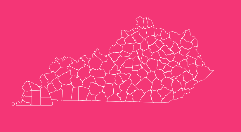
Despite ranking 37th in land area, the Commonwealth of Kentucky boasts 120 counties, the fourth-highest number in the nation, trailing only Texas, Georgia, and Virginia.
For researchers, travelers, and history buffs, navigating this dense geography can be a challenge without the right resources.
Geographical Overview of Kentucky
Kentucky is a state of diverse landscapes, and its county map reflects this variety.
To the east, you encounter the rugged terrain of the Cumberland Plateau and the Appalachian Mountains, home to some of the state’s largest counties by area.
Moving westward, the landscape softens into the rolling hills of the Bluegrass region, known for its fertile soil and horse farms, where counties are smaller and more densely packed.
Further west, the state flattens into the Pennyroyal Plateau and the Western Coal Fields, finally ending at the Jackson Purchase, bordered by the Mississippi River.
This geographical diversity influences population density.
The “Golden Triangle”, the area between Louisville, Lexington, and Northern Kentucky holds the majority of the state’s population and economic activity, while the rural counties in the east and west maintain a quieter, more agrarian lifestyle.
How to Use the Interactive Map Tool
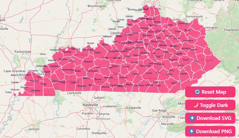
Hover and Highlight
Simply move your mouse over any county to see its name and FIPS code instantly pop up. This feature eliminates the guesswork of trying to read small text on a crowded map.
Zoom Capabilities
Use the scroll wheel or the +/- buttons to zoom in on the clustered counties of the Bluegrass region or zoom out for a statewide view.
Reset View
If you get lost in the details, hit the “Reset” button to instantly return to the full state perspective.
Dark Mode Toggle
For easier viewing in low-light environments, switch the toggle to “Dark Mode,” which inverts the color scheme for reduced eye strain.
Download Options
For those who need to take their data offline or require a base for a presentation, we offer several high-quality download formats:
- SVG (Scalable Vector Graphics): Best for graphic designers and publishers. You can resize the map without losing quality.
- PNG (Portable Network Graphics): Ideal for web use, documents, and quick sharing.
- Printable Blank Maps: Perfect for classrooms or plotting your own data points manually.
Detailed County Profiles
To give you a better understanding of the state’s demographics, let’s examine a few key counties that represent the diversity of the Commonwealth.
Jefferson County
As the economic engine of the state, Jefferson County encompasses the city of Louisville.
- Land Area: 380.8 square miles
- Population (2020 Census): 793,881
- Key Feature: It is a consolidated city-county government, meaning the city and county jurisdictions have merged.
Fayette County
Home to Lexington and the University of Kentucky, Fayette is the heart of horse country.
- Land Area: 283.6 square miles
- Population (2020 Census): 322,570 (Est. 329,437 in 2024)
- Key Feature: Like Jefferson, it operates under a merged Urban County Government structure.
Kenton County
Located at the very top of the state, Kenton County is part of the Greater Cincinnati metro area.
- Land Area: 160.3 square miles
- Population (2020 Census): 169,064 (Est. 174,862 in 2024)
- Key Feature: It historically had two county seats (Covington and Independence) to serve its elongated geography.
Pike County
Situated in the far eastern tip of the state, bordering West Virginia and Virginia.
- Land Area: 785.7 square miles
- Status: The largest county by land area.
- Key Feature: Known for its rich history in the coal industry and the famous Hatfield-McCoy feud.
Robertson County
Nestled in the rolling hills of the northeast.
- Land Area: 100.3 square miles
- Status: The smallest county by land area and population.
- Key Feature: It serves as a prime example of the hyper-local governance structure preferred in early Kentucky history.
History of County Formations (1776-1939)
The map of Kentucky has changed drastically over the centuries.
The Virginia Era (1776-1792)
Before it was a state, the land that is now Kentucky was a single county of Virginia, formed in 1776.
As the population swelled with settlers moving through the Cumberland Gap, “Kentucky County” became too large to manage. In 1780, it was split into three original counties:
- Fayette
- Jefferson
- Lincoln
Statehood and Expansion
By the time Kentucky was admitted to the Union in 1792, those three counties had been subdivided into nine.
The legislature continued to carve out new counties at a rapid pace throughout the 19th century to accommodate the growing population.
The 1891 Constitution
The fragmentation eventually had to stop. The Kentucky Constitution of 1891 put strict limits on the creation of new counties.
It stated that no new county could be formed unless it had at least 400 square miles of land and a population of 12,000.
It also prevented any existing county from being reduced below those limits. Since then, only one county, McCreary has been successfully formed (1912).
List of Kentucky Counties
Below is a reference table for all 120 counties, including their Federal Information Processing Standard (FIPS) codes, county seats, and the year they were established.
| County Name | FIPS Code | County Seat | Est. Year |
| Adair | 21001 | Columbia | 1802 |
| Allen | 21003 | Scottsville | 1815 |
| Anderson | 21005 | Lawrenceburg | 1827 |
| Ballard | 21007 | Wickliffe | 1842 |
| Barren | 21009 | Glasgow | 1798 |
| Bath | 21011 | Owingsville | 1811 |
| Bell | 21013 | Pineville | 1867 |
| Boone | 21015 | Burlington | 1798 |
| Bourbon | 21017 | Paris | 1785 |
| Boyd | 21019 | Catlettsburg | 1860 |
| Boyle | 21021 | Danville | 1842 |
| Bracken | 21023 | Brooksville | 1796 |
| Breathitt | 21025 | Jackson | 1839 |
| Breckinridge | 21027 | Hardinsburg | 1799 |
| Bullitt | 21029 | Shepherdsville | 1796 |
| Butler | 21031 | Morgantown | 1810 |
| Caldwell | 21033 | Princeton | 1809 |
| Calloway | 21035 | Murray | 1822 |
| Campbell | 21037 | Alexandria / Newport | 1794 |
| Carlisle | 21039 | Bardwell | 1886 |
| Carroll | 21041 | Carrollton | 1838 |
| Carter | 21043 | Grayson | 1838 |
| Casey | 21045 | Liberty | 1806 |
| Christian | 21047 | Hopkinsville | 1796 |
| Clark | 21049 | Winchester | 1792 |
| Clay | 21051 | Manchester | 1807 |
| Clinton | 21053 | Albany | 1835 |
| Crittenden | 21055 | Marion | 1842 |
| Cumberland | 21057 | Burkesville | 1798 |
| Daviess | 21059 | Owensboro | 1815 |
| Edmonson | 21061 | Brownsville | 1825 |
| Elliott | 21063 | Sandy Hook | 1869 |
| Estill | 21065 | Irvine | 1808 |
| Fayette | 21067 | Lexington | 1780 |
| Fleming | 21069 | Flemingsburg | 1798 |
| Floyd | 21071 | Prestonsburg | 1800 |
| Franklin | 21073 | Frankfort | 1794 |
| Fulton | 21075 | Hickman | 1845 |
| Gallatin | 21077 | Warsaw | 1798 |
| Garrard | 21079 | Lancaster | 1796 |
| Grant | 21081 | Williamstown | 1820 |
| Graves | 21083 | Mayfield | 1824 |
| Grayson | 21085 | Leitchfield | 1810 |
| Green | 21087 | Greensburg | 1792 |
| Greenup | 21089 | Greenup | 1803 |
| Hancock | 21091 | Hawesville | 1829 |
| Hardin | 21093 | Elizabethtown | 1792 |
| Harlan | 21095 | Harlan | 1819 |
| Harrison | 21097 | Cynthiana | 1793 |
| Hart | 21099 | Munfordville | 1819 |
| Henderson | 21101 | Henderson | 1798 |
| Henry | 21103 | New Castle | 1798 |
| Hickman | 21105 | Clinton | 1821 |
| Hopkins | 21107 | Madisonville | 1806 |
| Jackson | 21109 | McKee | 1858 |
| Jefferson | 21111 | Louisville | 1780 |
| Jessamine | 21113 | Nicholasville | 1798 |
| Johnson | 21115 | Paintsville | 1843 |
| Kenton | 21117 | Independence / Covington | 1840 |
| Knott | 21119 | Hindman | 1884 |
| Knox | 21121 | Barbourville | 1799 |
| Larue | 21123 | Hodgenville | 1843 |
| Laurel | 21125 | London | 1825 |
| Lawrence | 21127 | Louisa | 1821 |
| Lee | 21129 | Beattyville | 1870 |
| Leslie | 21131 | Hyden | 1878 |
| Letcher | 21133 | Whitesburg | 1842 |
| Lewis | 21135 | Vanceburg | 1806 |
| Lincoln | 21137 | Stanford | 1780 |
| Livingston | 21139 | Smithland | 1799 |
| Logan | 21141 | Russellville | 1792 |
| Lyon | 21143 | Eddyville | 1854 |
| Madison | 21151 | Richmond | 1785 |
| Magoffin | 21153 | Salyersville | 1860 |
| Marion | 21155 | Lebanon | 1834 |
| Marshall | 21157 | Benton | 1842 |
| Martin | 21159 | Inez | 1870 |
| Mason | 21161 | Maysville | 1788 |
| McCracken | 21145 | Paducah | 1825 |
| McCreary | 21147 | Whitley City | 1912 |
| McLean | 21149 | Calhoun | 1854 |
| Meade | 21163 | Brandenburg | 1823 |
| Menifee | 21165 | Frenchburg | 1869 |
| Mercer | 21167 | Harrodsburg | 1785 |
| Metcalfe | 21169 | Edmonton | 1860 |
| Monroe | 21171 | Tompkinsville | 1820 |
| Montgomery | 21173 | Mount Sterling | 1796 |
| Morgan | 21175 | West Liberty | 1822 |
| Muhlenberg | 21177 | Greenville | 1798 |
| Nelson | 21179 | Bardstown | 1784 |
| Nicholas | 21181 | Carlisle | 1799 |
| Ohio | 21183 | Hartford | 1798 |
| Oldham | 21185 | La Grange | 1823 |
| Owen | 21187 | Owenton | 1819 |
| Owsley | 21189 | Booneville | 1843 |
| Pendleton | 21191 | Falmouth | 1798 |
| Perry | 21193 | Hazard | 1820 |
| Pike | 21195 | Pikeville | 1821 |
| Powell | 21197 | Stanton | 1852 |
| Pulaski | 21199 | Somerset | 1798 |
| Robertson | 21201 | Mount Olivet | 1867 |
| Rockcastle | 21203 | Mount Vernon | 1810 |
| Rowan | 21205 | Morehead | 1856 |
| Russell | 21207 | Jamestown | 1825 |
| Scott | 21209 | Georgetown | 1792 |
| Shelby | 21211 | Shelbyville | 1792 |
| Simpson | 21213 | Franklin | 1819 |
| Spencer | 21215 | Taylorsville | 1824 |
| Taylor | 21217 | Campbellsville | 1848 |
| Todd | 21219 | Elkton | 1819 |
| Trigg | 21221 | Cadiz | 1820 |
| Trimble | 21223 | Bedford | 1837 |
| Union | 21225 | Morganfield | 1811 |
| Warren | 21227 | Bowling Green | 1796 |
| Washington | 21229 | Springfield | 1792 |
| Wayne | 21231 | Monticello | 1800 |
| Webster | 21233 | Dixon | 1860 |
| Whitley | 21235 | Williamsburg | 1818 |
| Wolfe | 21237 | Campton | 1860 |
| Woodford | 21239 | Versailles | 1788 |
Frequently Asked Questions
How many counties are in Kentucky?
There are 120 counties in Kentucky. This gives it the fourth-highest number of counties in the U.S., despite the state’s moderate size.
Which Kentucky county has the largest population?
Jefferson County is the most populous, with approximately 793,881 residents. It contains the state’s largest city, Louisville.
Which county is the largest by land area?
Pike County is the largest, covering 785.7 square miles. It is known for its rugged terrain in the Appalachian region.
What is the smallest county in Kentucky?
Robertson County is the smallest by land area (100.3 square miles) and also has the smallest population (approx. 2,200).
What was the first county formed in Kentucky?
Before statehood, the area was “Kentucky County,” Virginia. In 1780, it was split into the first three true counties: Jefferson, Lincoln, and Fayette.
Can new counties still be formed in Kentucky?
It is very difficult. The 1891 Constitution requires new counties to have at least 400 square miles and 12,000 residents, which makes subdivision legally challenging.
Which counties are in the “Golden Triangle”?
The Golden Triangle refers to the economic hub contained within the regions of Lexington (Fayette County), Louisville (Jefferson County), and Northern Kentucky (Boone, Kenton, and Campbell Counties).
Are there dry counties in Kentucky?
Yes. Kentucky has a patchwork of “dry,” “wet,” and “moist” counties regarding alcohol sales, a legacy of local option laws, though many are converting to wet or moist status to boost tourism.
What is a “consolidated” county government?
Jefferson County (Louisville) and Fayette County (Lexington) operate as consolidated governments, where the city and county administrations are merged into a single entity.
Conclusion
Whether you are using our interactive features to zoom into specific regions or downloading a high-resolution map for your research, having access to accurate county data is invaluable.
Ready to explore the Bluegrass State? Download your free high-resolution Kentucky County Map today!