When you look at a map of the United States, Kansas sits right in the heart of the country. But zooming in reveals a complex grid that tells a much deeper story.
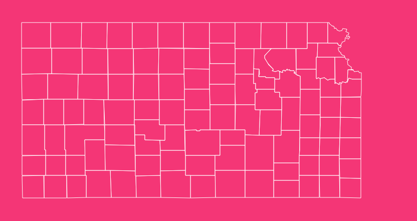
With 105 counties, Kansas has the fifth-highest number of counties in the nation, trailing only Texas, Georgia, Virginia, and Kentucky. This density creates a fascinating patchwork of local governance, history, and geography.
Whether you are a student researching the “Bleeding Kansas” era, a logistics manager calculating freight routes, or a traveler looking to visit every county seat from St. Francis to Baxter Springs, having accurate map data is essential.
How to Use the Interactive Map Tool
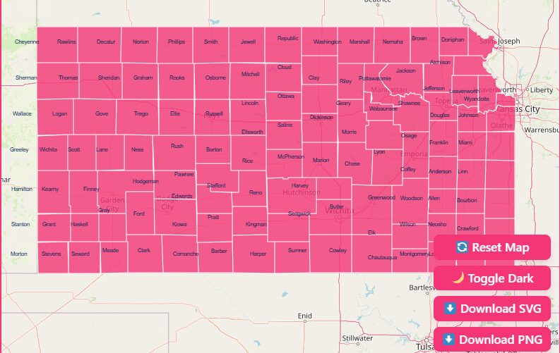
Hover Highlight
Simply move your mouse (or tap your finger on mobile) over any county. The specific county will highlight, and a tooltip will appear displaying the county name and seat.
Zoom In/Out
Use the + and – buttons in the top right corner of the map frame to focus on specific metropolitan areas like Wichita (Sedgwick County) or Kansas City (Wyandotte County).
Reset Button
If you have zoomed in too far or lost your orientation, click the “Reset” arrow to instantly return the map to the full state view.
Dark Mode Toggle
Working late? Switch the visual theme by clicking the moon icon. This inverts the color scheme to reduce eye strain and makes the county borders pop against a dark background.
Download Options
For users who need to take this map offline or use it for presentations, we offer two distinct high-resolution formats:
Download Blank Printable SVG
Best for graphic designers. This vector format allows you to scale the map to any size (even a billboard) without losing quality. It is fully editable in software like Adobe Illustrator.
Download PNG Image
Best for documents and quick printing. This is a standard high-quality image file perfect for inserting into Word documents, PowerPoint presentations, or school reports.
Historical Overview: How 105 Counties Were Formed
The map of Kansas hasn’t always looked this uniform. The history of these county lines is a history of the American frontier itself.
The Territorial Era (1854–1861)
Before Kansas was a state, it was a territory defined by conflict. The first counties were established in 1855 by the first territorial legislature. At this time, 36 counties were created in the eastern third of the state.
Many of these original boundaries remain today, though some names have changed to reflect shifting political alliances after the Civil War.
The Railroad Expansion (1860s–1880s)
As settlers moved westward, driven by the Homestead Act and the expansion of the railroads, new counties were carved out of the open prairie.
The philosophy at the time was practical: a resident should be able to travel to their county seat and back in a single day by horse and buggy.
This logic is why Kansas has so many small, square counties, particularly in the central and western regions.
Stabilization
By the late 1880s, the map we recognize today was largely finalized.
While there have been minor border disputes and dissolved counties (such as Garfield County, which was annexed into Finney County due to an illegal survey), the grid of 105 has remained the standard for over a century.
Geographical Overview of Kansas Regions
While the map grid looks uniform, the geography beneath it is surprisingly diverse. Understanding the four main quadrants of the map helps contextualize the data.
Northeast Kansas (The Glaciated Region)
Here you find the most irregular county shapes. Bordered by the Missouri River, counties like Doniphan and Atchison feature rolling hills and dense forests.
This area was the first to be settled and remains the political hub, housing the state capital in Shawnee County.
Southeast Kansas (The Osage Cuestas)
Counties such as Cherokee and Crawford sit in a region defined by mining history and different geological ridges (cuestas).
This area connects geographically to the Ozarks and has a distinct industrial heritage compared to the rest of the agricultural state.
Central Kansas (The Smoky Hills)
Moving west, the elevation rises. Counties like Ellsworth and Russell feature the Smoky Hills, sandstone formations and mixed-grass prairie.
This is the transition zone between the corn/soybean fields of the east and the wheat fields of the west.
Western Kansas (The High Plains)
The western counties (like Greeley, Wallace, and Sherman) are larger, rectangular, and sparsely populated.
This is the High Plains region, which rises steadily in elevation toward the Colorado border. It is the heart of the state’s cattle and wheat industries.
Important Kansas County Insights
Analyzing the data across the map reveals significant trends that affect economics and government.
Population Disparity
Johnson County (Kansas City metro) has a population of over 600,000, while Greeley County on the Colorado border often records fewer than 1,300 residents.
This massive gap creates unique challenges for state resource allocation.
The “Tag” System
If you live in Kansas, you likely know your county by its two-letter abbreviation on license plates (e.g., “SN” for Shawnee, “SG” for Sedgwick).
This system dates back to 1930 and helps locals instantly identify where a car is from.
Unified Government
Wyandotte County is unique in that it operates as a “Unified Government” (UG) with Kansas City, Kansas. This consolidation occurred in 1997 to streamline services and reduce administrative overhead.
List of Kansas Counties
| County Name | FIPS Code | County Seat | Established |
| Allen County | 001 | Iola | 1855 |
| Anderson County | 003 | Garnett | 1855 |
| Atchison County | 005 | Atchison | 1855 |
| Barber County | 007 | Medicine Lodge | 1867 |
| Barton County | 009 | Great Bend | 1867 |
| Bourbon County | 011 | Fort Scott | 1855 |
| Brown County | 013 | Hiawatha | 1855 |
| Butler County | 015 | El Dorado | 1855 |
| Chase County | 017 | Cottonwood Falls | 1859 |
| Chautauqua County | 019 | Sedan | 1875 |
| Cherokee County | 021 | Columbus | 1855 |
| Cheyenne County | 023 | St. Francis | 1873 |
| Clark County | 025 | Ashland | 1885 |
| Clay County | 027 | Clay Center | 1857 |
| Cloud County | 029 | Concordia | 1866 |
| Coffey County | 031 | Burlington | 1855 |
| Comanche County | 033 | Coldwater | 1867 |
| Cowley County | 035 | Winfield | 1867 |
| Crawford County | 037 | Girard | 1867 |
| Decatur County | 039 | Oberlin | 1873 |
| Dickinson County | 041 | Abilene | 1857 |
| Doniphan County | 043 | Troy | 1855 |
| Douglas County | 045 | Lawrence | 1855 |
| Edwards County | 047 | Kinsley | 1874 |
| Elk County | 049 | Howard | 1875 |
| Ellis County | 051 | Hays | 1867 |
| Ellsworth County | 053 | Ellsworth | 1867 |
| Finney County | 055 | Garden City | 1883 |
| Ford County | 057 | Dodge City | 1867 |
| Franklin County | 059 | Ottawa | 1855 |
| Geary County | 061 | Junction City | 1855 |
| Gove County | 063 | Gove City | 1868 |
| Graham County | 065 | Hill City | 1867 |
| Grant County | 067 | Ulysses | 1888 |
| Gray County | 069 | Cimarron | 1887 |
| Greeley County | 071 | Tribune | 1873 |
| Greenwood County | 073 | Eureka | 1855 |
| Hamilton County | 075 | Syracuse | 1873 |
| Harper County | 077 | Anthony | 1867 |
| Harvey County | 079 | Newton | 1872 |
| Haskell County | 081 | Sublette | 1887 |
| Hodgeman County | 083 | Jetmore | 1867 |
| Jackson County | 085 | Holton | 1855 |
| Jefferson County | 087 | Oskaloosa | 1855 |
| Jewell County | 089 | Mankato | 1867 |
| Johnson County | 091 | Olathe | 1855 |
| Kearny County | 093 | Lakin | 1887 |
| Kingman County | 095 | Kingman | 1872 |
| Kiowa County | 097 | Greensburg | 1886 |
| Labette County | 099 | Oswego | 1867 |
| Lane County | 101 | Dighton | 1873 |
| Leavenworth County | 103 | Leavenworth | 1855 |
| Lincoln County | 105 | Lincoln Center | 1867 |
| Linn County | 107 | Mound City | 1855 |
| Logan County | 109 | Oakley | 1888 |
| Lyon County | 111 | Emporia | 1855 |
| McPherson County | 113 | McPherson | 1867 |
| Marion County | 115 | Marion | 1860 |
| Marshall County | 117 | Marysville | 1855 |
| Meade County | 119 | Meade | 1885 |
| Miami County | 121 | Paola | 1855 |
| Mitchell County | 123 | Beloit | 1867 |
| Montgomery County | 125 | Independence | 1867 |
| Morris County | 127 | Council Grove | 1855 |
| Morton County | 129 | Elkhart | 1886 |
| Nemaha County | 131 | Seneca | 1855 |
| Neosho County | 133 | Erie | 1855 |
| Ness County | 135 | Ness City | 1867 |
| Norton County | 137 | Norton | 1867 |
| Osage County | 139 | Lyndon | 1855 |
| Osborne County | 141 | Osborne | 1867 |
| Ottawa County | 143 | Minneapolis | 1860 |
| Pawnee County | 145 | Larned | 1867 |
| Phillips County | 147 | Phillipsburg | 1867 |
| Pottawatomie County | 149 | Westmoreland | 1857 |
| Pratt County | 151 | Pratt | 1867 |
| Rawlins County | 153 | Atwood | 1873 |
| Reno County | 155 | Hutchinson | 1867 |
| Republic County | 157 | Belleville | 1868 |
| Rice County | 159 | Lyons | 1867 |
| Riley County | 161 | Manhattan | 1855 |
| Rooks County | 163 | Stockton | 1867 |
| Rush County | 165 | La Crosse | 1867 |
| Russell County | 167 | Russell | 1867 |
| Saline County | 169 | Salina | 1860 |
| Scott County | 171 | Scott City | 1873 |
| Sedgwick County | 173 | Wichita | 1867 |
| Seward County | 175 | Liberal | 1873 |
| Shawnee County | 177 | Topeka | 1855 |
| Sheridan County | 179 | Hoxie | 1873 |
| Sherman County | 181 | Goodland | 1873 |
| Smith County | 183 | Smith Center | 1867 |
| Stafford County | 185 | St. John | 1867 |
| Stanton County | 187 | Johnson City | 1887 |
| Stevens County | 189 | Hugoton | 1886 |
| Sumner County | 191 | Wellington | 1871 |
| Thomas County | 193 | Colby | 1885 |
| Trego County | 195 | WaKeeney | 1873 |
| Wabaunsee County | 197 | Alma | 1859 |
| Wallace County | 199 | Sharon Springs | 1888 |
| Washington County | 201 | Washington | 1857 |
| Wichita County | 203 | Leoti | 1886 |
| Wilson County | 205 | Fredonia | 1865 |
| Woodson County | 207 | Yates Center | 1855 |
| Wyandotte County | 209 | Kansas City | 1859 |
Frequently Asked Questions
What is the largest county in Kansas by land area?
Butler County is the largest county in Kansas, spanning approximately 1,428 square miles. It is located just east of Wichita and is known for the Flint Hills.
What is the smallest county in Kansas?
Wyandotte County is the smallest, covering only about 156 square miles. Despite its size, it is densely populated as it contains Kansas City, Kansas.
How many counties does Kansas have compared to other states?
Kansas has 105 counties, which is the 5th highest number in the United States, following Texas (254), Georgia (159), Virginia (133), and Kentucky (120).
Why are Kansas counties so square?
Most Kansas counties, particularly in the west, were surveyed using the Public Land Survey System (PLSS). This system divided land into 6-mile square townships, resulting in the grid-like, rectangular shape of many counties.
Which Kansas county has the highest population?
Johnson County is the most populous, with over 600,000 residents. It is a major suburban hub of the Kansas City metropolitan area.
What is the oldest county in Kansas?
While many counties were established simultaneously in 1855 by the first territorial legislature (such as Leavenworth, Douglas, and Allen), they are collectively considered the oldest group of counties in the state.
What is the newest county in Kansas?
Generally, the western counties were the last to be organized. However, counties like Logan (originally St. John) and Kearny were some of the final ones to establish their current borders and names in the late 1880s.
What is the “County Seat War”?
In the late 1800s, many Kansas towns fought violent battles (sometimes involving gunfire) to become the county seat.
The designation meant economic survival. Famous seat wars occurred in counties like Stevens and Gray.
Start Using the Map Today
Ready to integrate this data into your workflow? Whether you are printing a map for a classroom, analyzing sales territories, or just curious about the geography of the Sunflower State, our tool is here to help.
[Download the Full SVG Map Now].