When you look at a map of the United States, Iowa stands out for its neat, grid-like precision. But zoom in on an Iowa state map with counties, and you’ll find a complex tapestry of history, geography, and demographics.
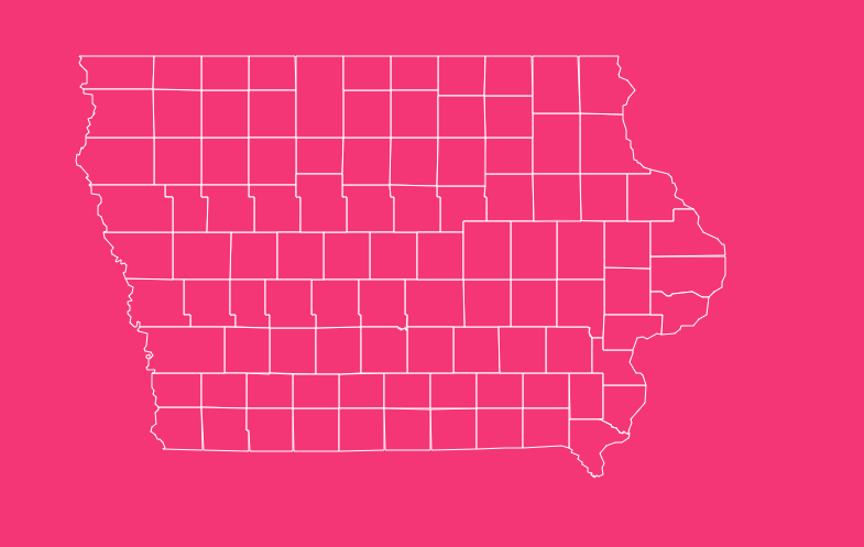
With 99 counties packed into its borders, the Hawkeye State offers one of the most subdivided political landscapes in the country.
Whether you are a researcher, a student, a logistics planner, or simply a curious traveler, understanding the layout of Iowa’s counties is essential.
Geographical Overview of Iowa
Iowa is defined by its rivers. Bounded by the Mississippi River to the east and the Missouri and Big Sioux Rivers to the west, it is the only state in the U.S. with two parallel rivers defining its borders.
Within these watery boundaries lies a land area of roughly 55,869 square miles. While often thought of as flat, the state features rolling hills, especially in the Driftless Area of the northeast and the Loess Hills in the west.
The County Structure
Why does the Iowa county map look like a checkerboard? Iowa has 99 counties, a high number given its geographic size (it ranks 26th in area but 10th in number of counties).
This density was intentional by early surveyors and legislators, designed to ensure that any resident could travel to their county seat and return home within a single day by horse and buggy.
How to Use the Interactive Map Tool
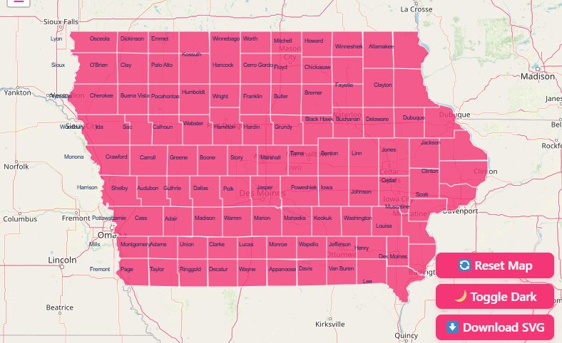
Navigating a static PDF map can be frustrating when you need granular data. Our interactive Iowa county map is designed for flexibility and depth. Here is how to get the most out of the features:
Hover and Highlight
Stop squinting at tiny text. Simply move your mouse (or tap) over any county on the map.
Zoom In and Out
Need to see the specific borders between Polk and Warren counties? Use the + and – buttons or the scroll wheel on your mouse to zoom in for a granular view.
Dark Mode Toggle
If you are working late or simply prefer a high-contrast interface, switch on Dark Mode.
Reset Button
Got lost in a deep zoom of rural Kossuth County? Hit the Reset button to instantly snap the view back to the full state perspective.
Download Options: Blank, SVG, and PNG
We know that sometimes you need a map you can hold in your hand or edit in design software.
Printable PNG
Download a high-resolution raster image. This is perfect for inclusion in reports, homework assignments, or quick reference sheets.
Editable SVG
For graphic designers and publishers, the Scalable Vector Graphics (SVG) format allows you to resize the map infinitely without quality loss.
Historical Overview of County Formation
The map of Iowa didn’t always look this uniform. The history of these boundaries is a fascinating look into 19th-century American expansion.
The Early Days (1834)
Before Iowa was even a state, it was part of the Michigan Territory. In 1834, the first two counties were established: Dubuque and Des Moines. They originally split the entire territory in half.
Statehood (1846)
By the time Iowa was admitted to the Union in 1846, 44 counties had been established.
The Great Expansion (1851)
One of the most significant dates in Iowa history is January 15, 1851. On this single day, the state legislature created 49 new counties, laying out the grid structure we recognize today.
The “Lost” 100th County
Iowa had almost 100 counties. Bancroft County was established in 1851 but was later abolished and merged into Kossuth County in 1855 because the area was too swampy and sparsely populated to support a local government.
Important Iowa County Insights
Analyzing the Iowa state map with counties reveals significant disparities in population and land area. Here is a breakdown of the extremes based on U.S. Census data.
Population Extremes (2020 Census)
Iowa’s population is shifting toward urban centers, leaving rural counties with smaller populations.
- Most Populated: Polk County (492,401 people). Home to Des Moines, the state capital and economic engine.
- Least Populated: Adams County (3,704 people). Located in southwest Iowa, this rural county reflects the quiet, agricultural lifestyle of the region.
Geographic Size
Largest County
Kossuth County (973 sq. miles). Located in the north-central part of the state, it is roughly double the size of standard counties because it absorbed the defunct Bancroft County.
Smallest County (Land Area)
Dickinson County (381 sq. miles). While Osceola is often cited as the smallest, Dickinson technically has the smallest land area due to its Great Lakes (Okoboji and Spirit Lake) taking up significant acreage.
Key Urban Centers
If you are looking for business or cultural hubs, keep an eye on these counties:
- Linn County: Home to Cedar Rapids.
- Scott County: Home to Davenport (part of the Quad Cities).
- Johnson County: Home to Iowa City and the University of Iowa.
The Importance of County Data
Why does this map matter? County-level data is the backbone of decision-making in the state.
Political Analysis
Iowa is famous for its “First in the Nation” caucuses. Political strategists rely on county maps to track voting trends between rural and urban districts.
Resource Allocation
State funding for roads, schools, and emergency services is often distributed based on county population and area data.
Genealogy
For those tracing their roots, knowing the Established Year of a county is vital. Records for a town might be in one county in 1840 and a different one in 1855 due to shifting borders.
Complete List of Iowa Counties
The following table provides the essential data for all 99 counties, including their Federal Information Processing Standards (FIPS) code, county seat, and the year they were legally established.
| County Name | FIPS Code | County Seat | Established Year |
| Adair County | 19-001 | Greenfield | 1851 |
| Adams County | 19-003 | Corning | 1851 |
| Allamakee County | 19-005 | Waukon | 1847 |
| Appanoose County | 19-007 | Centerville | 1843 |
| Audubon County | 19-009 | Audubon | 1851 |
| Benton County | 19-011 | Vinton | 1837 |
| Black Hawk County | 19-013 | Waterloo | 1843 |
| Boone County | 19-015 | Boone | 1846 |
| Bremer County | 19-017 | Waverly | 1851 |
| Buchanan County | 19-019 | Independence | 1837 |
| Buena Vista County | 19-021 | Storm Lake | 1851 |
| Butler County | 19-023 | Allison | 1851 |
| Calhoun County | 19-025 | Rockwell City | 1851 |
| Carroll County | 19-027 | Carroll | 1851 |
| Cass County | 19-029 | Atlantic | 1851 |
| Cedar County | 19-031 | Tipton | 1837 |
| Cerro Gordo County | 19-033 | Mason City | 1851 |
| Cherokee County | 19-035 | Cherokee | 1851 |
| Chickasaw County | 19-037 | New Hampton | 1851 |
| Clarke County | 19-039 | Osceola | 1846 |
| Clay County | 19-041 | Spencer | 1851 |
| Clayton County | 19-043 | Elkader | 1837 |
| Clinton County | 19-045 | Clinton | 1837 |
| Crawford County | 19-047 | Denison | 1851 |
| Dallas County | 19-049 | Adel | 1846 |
| Davis County | 19-051 | Bloomfield | 1843 |
| Decatur County | 19-053 | Leon | 1846 |
| Delaware County | 19-055 | Manchester | 1837 |
| Des Moines County | 19-057 | Burlington | 1834 |
| Dickinson County | 19-059 | Spirit Lake | 1851 |
| Dubuque County | 19-061 | Dubuque | 1834 |
| Emmet County | 19-063 | Estherville | 1851 |
| Fayette County | 19-065 | West Union | 1837 |
| Floyd County | 19-067 | Charles City | 1851 |
| Franklin County | 19-069 | Hampton | 1851 |
| Fremont County | 19-071 | Sidney | 1847 |
| Greene County | 19-073 | Jefferson | 1851 |
| Grundy County | 19-075 | Grundy Center | 1851 |
| Guthrie County | 19-077 | Guthrie Center | 1851 |
| Hamilton County | 19-079 | Webster City | 1856 |
| Hancock County | 19-081 | Garner | 1851 |
| Hardin County | 19-083 | Eldora | 1851 |
| Harrison County | 19-085 | Logan | 1851 |
| Henry County | 19-087 | Mount Pleasant | 1836 |
| Howard County | 19-089 | Cresco | 1851 |
| Humboldt County | 19-091 | Dakota City | 1857 |
| Ida County | 19-093 | Ida Grove | 1851 |
| Iowa County | 19-095 | Marengo | 1843 |
| Jackson County | 19-097 | Maquoketa | 1837 |
| Jasper County | 19-099 | Newton | 1846 |
| Jefferson County | 19-101 | Fairfield | 1839 |
| Johnson County | 19-103 | Iowa City | 1837 |
| Jones County | 19-105 | Anamosa | 1837 |
| Keokuk County | 19-107 | Sigourney | 1837 |
| Kossuth County | 19-109 | Algona | 1851 |
| Lee County | 19-111 | Fort Madison | 1836 |
| Linn County | 19-113 | Cedar Rapids | 1837 |
| Louisa County | 19-115 | Wapello | 1836 |
| Lucas County | 19-117 | Chariton | 1846 |
| Lyon County | 19-119 | Rock Rapids | 1851 |
| Madison County | 19-121 | Winterset | 1846 |
| Mahaska County | 19-123 | Oskaloosa | 1843 |
| Marion County | 19-125 | Knoxville | 1845 |
| Marshall County | 19-127 | Marshalltown | 1846 |
| Mills County | 19-129 | Glenwood | 1851 |
| Mitchell County | 19-131 | Osage | 1851 |
| Monona County | 19-133 | Onawa | 1851 |
| Monroe County | 19-135 | Albia | 1843 |
| Montgomery County | 19-137 | Red Oak | 1851 |
| Muscatine County | 19-139 | Muscatine | 1836 |
| O’Brien County | 19-141 | Primghar | 1851 |
| Osceola County | 19-143 | Sibley | 1851 |
| Page County | 19-145 | Clarinda | 1847 |
| Palo Alto County | 19-147 | Emmetsburg | 1851 |
| Plymouth County | 19-149 | Le Mars | 1851 |
| Pocahontas County | 19-151 | Pocahontas | 1851 |
| Polk County | 19-153 | Des Moines | 1846 |
| Pottawattamie County | 19-155 | Council Bluffs | 1847 |
| Poweshiek County | 19-157 | Montezuma | 1843 |
| Ringgold County | 19-159 | Mount Ayr | 1847 |
| Sac County | 19-161 | Sac City | 1851 |
| Scott County | 19-163 | Davenport | 1837 |
| Shelby County | 19-165 | Harlan | 1851 |
| Sioux County | 19-167 | Orange City | 1851 |
| Story County | 19-169 | Nevada | 1846 |
| Tama County | 19-171 | Toledo | 1843 |
| Taylor County | 19-173 | Bedford | 1847 |
| Union County | 19-175 | Creston | 1851 |
| Van Buren County | 19-177 | Keosauqua | 1836 |
| Wapello County | 19-179 | Ottumwa | 1843 |
| Warren County | 19-181 | Indianola | 1846 |
| Washington County | 19-183 | Washington | 1839 |
| Wayne County | 19-185 | Corydon | 1846 |
| Webster County | 19-187 | Fort Dodge | 1853 |
| Winnebago County | 19-189 | Forest City | 1851 |
| Winneshiek County | 19-191 | Decorah | 1847 |
| Woodbury County | 19-193 | Sioux City | 1853 |
| Worth County | 19-195 | Northwood | 1851 |
| Wright County | 19-197 | Clarion | 1851 |
Frequently Asked Questions
How many counties are in Iowa?
There are 99 counties in Iowa. It has held this number since 1857, when Humboldt County was created.
Which Iowa county has the largest population?
Polk County is the most populous, with 492,401 residents according to the 2020 Census. It is home to Des Moines.
Which county is the largest by area?
Kossuth County is the largest, covering approximately 973 square miles. It is roughly twice the size of a standard Iowa county because it absorbed Bancroft County in 1855.
Why does Iowa have 99 counties instead of 100?
Iowa nearly had 100 counties. However, Bancroft County was dissolved shortly after its creation because it was largely wetland and lacked enough population to govern itself, leaving the state with 99.
What are the first counties established in Iowa?
Dubuque County and Des Moines County were both established on September 6, 1834, when the land was still part of the Michigan Territory.
Which Iowa county has the smallest population?
Adams County is the least populous, with just 3,704 residents recorded in the 2020 Census.
Why are Iowa counties so square?
Most Iowa counties were surveyed using the Public Land Survey System, which divides land into 6-mile-square townships. This resulted in the uniform, rectangular shapes seen on the map today.
What is the FIPS code for Iowa counties?
FIPS (Federal Information Processing Standards) codes are unique identifiers for counties. Iowa’s state code is 19, so all county codes start with 19 (e.g., Adair County is 19-001).
Where is the capital of Iowa located?
The capital, Des Moines, is located in Polk County, which is centrally located in the state.
Can I download a blank Iowa county map?
Yes, using the tool on this page, you can download a blank SVG or PNG map of Iowa counties for educational or design purposes.
Start Exploring Iowa Today
Use the interactive features above to find the data you need, download the maps for your projects, and gain a better understanding of the Hawkeye State.
Explore the ultimate Iowa state map with counties. Get population data, historical insights, and download interactive SVG/PNG maps for all 99 counties.