Alaska is a land of superlatives. It is the largest, northernmost, and arguably most rugged state in the union.
But for researchers, travelers, and business owners, Alaska presents a unique challenge: it doesn’t follow the standard rules of American geography.
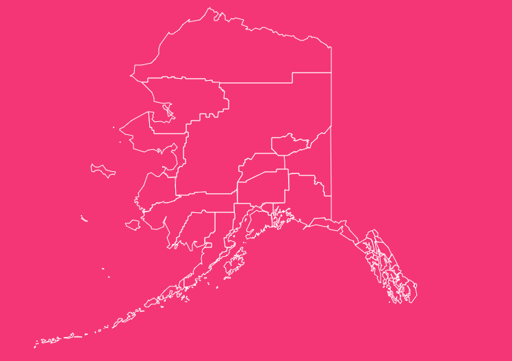
Unlike the other 49 states, Alaska does not strictly use “counties.” Instead, it utilizes a complex system of boroughs and census areas that can confuse even the most seasoned geographers.
Understanding Alaska’s Unique Divisions
Before diving into the map, it is vital to understand what you are looking at. If you search for “Alaska counties,” you will technically find none.
The state constitution defines a unique system that reflects the state’s low population density and massive land area.
Boroughs vs. Counties
In Alaska, the functional equivalent of a county is a Borough. Organized boroughs function similarly to counties in the Lower 48 states.
They have local governments, collect taxes, and manage school districts and zoning.
However, not all boroughs are created equal. Some, like the Municipality of Anchorage or the City and Borough of Juneau, are “consolidated city-boroughs.”
This means the city government and the county-level government are merged into a single jurisdiction.
The Unorganized Borough
Here is where Alaska truly differs from the rest of the nation. More than half of Alaska’s landmass is not part of any organized borough.
This area is collectively known as the Unorganized Borough.
If this area were a state, it would be larger than Texas. Because there is no borough government here, the State of Alaska provides necessary services directly.
Census Areas
For statistical purposes like tracking population and demographics the U.S. The Census Bureau divides the Unorganized Borough into Census Areas.
It is important to remember that these are not local governments. A resident of the Bethel Census Area does not have a “county seat” in the traditional sense.
These lines exist primarily for data analysis, which makes our interactive map a crucial tool for visualizing these invisible boundaries.
Historical Overview of County Formation
Alaska’s approach to local government was debated heavily during the road to statehood in the 1950s.
The framers of the Alaska Constitution wanted to avoid the rigid county system found in other states, which they felt resulted in too much bureaucracy and inefficiency.
Instead, they adopted the borough system in 1961, shortly after statehood in 1959.
The goal was to provide local control where the population was dense enough to support it, while the state managed the vast, sparsely populated hinterlands.
Over time, new boroughs have formed as populations grew, such as the Petersburg Borough establishing itself as recently as 2013.
Geographical Overview of Alaska
To understand the map, one must grasp the scale. Alaska spans 663,000 square miles.
It stretches from the temperate rainforests of the Southeast Panhandle to the Arctic tundra of the North Slope, and out to the volcanic Aleutian Islands.
This massive geography dictates the administrative lines.
For example, the North Slope Borough alone is larger than the entire state of Minnesota, yet it is home to fewer than 10,000 people.
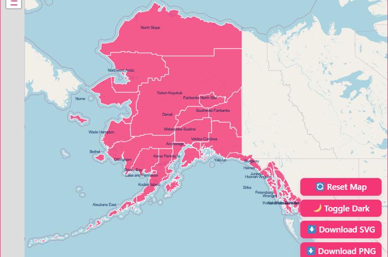
How to Use the Interactive Alaska State Map
Navigation
Zoom
Use the + and – buttons in the corner, or use your mouse wheel to zoom in for a granular view of the Southeast panhandle, or zoom out to see the full scope of the state.
Pan
Click and drag anywhere on the map to move across the different regions.
Reset
If you get lost in the Aleutians, hit the Reset button to return to the default statewide view.
Interacting with Data
Hover Highlight
Simply move your mouse over any area. The map will highlight the border of the borough or census area, separating it from its neighbors.
Click for Info
Click on any highlighted region to open a pop-up window. This will display key details such as the name of the borough/census area and its FIPS code.
Customization and Downloads
Dark Mode
Working late or prefer a high-contrast interface? Toggle the Dark Mode switch to invert the map colors.
Download PNG
Need an image for a report? Click the download button to save the current view as a high-resolution PNG image.
Printable Map
Educators often need a blank map for quizzes or classroom activities. Use the “Download SVG” option to get a crisp, scalable vector file that serves as a perfect printable map.
Benefits of Using the Interactive Map
Different users will find distinct value in this tool:
Educators
Geography teachers can use the blank map feature to teach students about Alaska’s unique administrative structure.
Travel Planners
Understanding which borough you are in can help with understanding local laws, sales tax rates, and emergency services availability during a road trip.
Real Estate Professionals
Property values and taxes vary wildly between organized boroughs and the Unorganized Borough. This map helps clarify jurisdiction quickly.
Government Agencies
For those managing logistics or infrastructure, visualizing the vast distances between census areas is critical for resource allocation.
Important Alaska County Insights
Using data visualized on the map, we can see stark contrasts across the state:
Most Populous
The Municipality of Anchorage holds the top spot, housing nearly 40% of the state’s residents.
Largest by Area
The North Slope Borough is the largest county-level political subdivision in the United States by area.
Economic Variance
The Denali Borough is often cited as one of the wealthiest areas due to tourism, while the Kusilvak Census Area faces significant economic challenges.
Newest Borough
The Petersburg Borough was formed in 2013, highlighting that Alaska’s map is still evolving.
The Importance of County Data
Why does this data matter? In the Lower 48, county lines determine everything from police jurisdiction to school funding. In Alaska, the distinction between a Borough and a Census Area affects:
Taxation
Residents in the Unorganized Borough generally do not pay property taxes to a local government, although they may pay distinct taxes to the state.
Representation
Boroughs have mayors and assemblies; Census Areas do not.
Federal Funding
Many federal grants are allocated based on FIPS codes and census data, making accurate mapping of these areas vital for community funding.
Alaska at a Glance: Quick County Equivalent Facts
Here is a fast snapshot of Alaska’s administrative structure to help you understand the divisions you see on the map:
| Feature | Details |
| Total Boroughs | 19 |
| Total Census Areas | 11 |
| Total County-Equivalent Divisions | 30 |
| Largest Borough by Area | North Slope Borough |
| Most Populated Borough | Municipality of Anchorage |
| Smallest Borough by Population | Yakutat City and Borough |
| Newest Borough | Petersburg Borough (est. 2013) |
| Largest Census Area | Yukon–Koyukuk Census Area |
| Geographical Extremes | Arctic tundra to temperate rainforest |
| Unorganized Borough | Covers more land than Texas |
List of All Alaska Boroughs and Census Areas
Below is a reference table containing the FIPS codes and seats (where applicable) for Alaska’s divisions. Note that Census Areas do not have a formal “seat” of government.
Organized Boroughs
| Borough Name | FIPS Code | Borough Seat | Established |
| Aleutians East Borough | 013 | Sand Point | 1987 |
| Anchorage, Municipality of | 020 | Anchorage | 1975 |
| Bristol Bay Borough | 060 | Naknek | 1962 |
| Denali Borough | 068 | Healy | 1990 |
| Fairbanks North Star Borough | 090 | Fairbanks | 1964 |
| Haines Borough | 100 | Haines | 1968 |
| Juneau, City and Borough of | 110 | Juneau | 1970 |
| Kenai Peninsula Borough | 122 | Soldotna | 1964 |
| Ketchikan Gateway Borough | 130 | Ketchikan | 1963 |
| Kodiak Island Borough | 150 | Kodiak | 1963 |
| Lake and Peninsula Borough | 164 | King Salmon | 1989 |
| Matanuska-Susitna Borough | 170 | Palmer | 1964 |
| North Slope Borough | 185 | Utqiaġvik | 1972 |
| Northwest Arctic Borough | 188 | Kotzebue | 1986 |
| Petersburg Borough | 195 | Petersburg | 2013 |
| Sitka, City and Borough of | 220 | Sitka | 1971 |
| Skagway, Municipality of | 230 | Skagway | 2007 |
| Wrangell, City and Borough of | 275 | Wrangell | 2008 |
| Yakutat, City and Borough of | 282 | Yakutat | 1992 |
Census Areas (Unorganized Borough)
| Census Area Name | FIPS Code | Largest Town/Hub |
| Aleutians West Census Area | 016 | Unalaska |
| Bethel Census Area | 050 | Bethel |
| Chugach Census Area | 063 | Valdez |
| Copper River Census Area | 066 | Glennallen |
| Dillingham Census Area | 070 | Dillingham |
| Hoonah–Angoon Census Area | 105 | Hoonah |
| Kusilvak Census Area | 158 | Hooper Bay |
| Nome Census Area | 180 | Nome |
| Prince of Wales-Hyder Census Area | 198 | Craig |
| Southeast Fairbanks Census Area | 240 | Deltana |
| Yukon-Koyukuk Census Area | 290 | Fort Yukon |
Frequently Asked Questions (FAQs)
How many counties does Alaska have?
Technically, Alaska has zero traditional counties. Instead, it uses 19 organized boroughs and 11 census areas, which together function as county-equivalent divisions.
What is the Unorganized Borough in Alaska?
The Unorganized Borough is a massive region with no local county-level government. The State of Alaska directly provides major services here, including education, taxation, and infrastructure.
Why does Alaska not use counties like other states?
Alaska’s constitution intentionally avoids the county system because its population is sparse and unevenly distributed. The borough model allows local government only where communities can support it.
What is the difference between a borough and a census area?
A borough has a local government, mayor, and taxing authority.
A census area has no county-level government and exists only for statistical purposes within the Unorganized Borough.
What is the largest borough in Alaska?
The North Slope Borough is the largest county-level subdivision in the United States by land area.
What is the smallest borough in Alaska by population?
The Yakutat City and Borough ranks among the smallest by population despite its large geographic footprint.
Can I download a blank Alaska county map for school?
Yes. This page includes free PNG and SVG downloads that work for school assignments, geography quizzes, and printable worksheets.
Does Google Maps show Alaska borough boundaries?
Google Maps displays borough boundaries only when searching for a specific borough name. It does not show all lines at once like our interactive map does.
Explore Alaska Today
Alaska’s geography is as complex as it is beautiful. Whether you are conducting academic research, planning business logistics, or simply trying to understand the Last Frontier a little better, visualizing the data is the first step.
Don’t let the complexity of boroughs and census areas confuse you. Use our tool to navigate the state with confidence.
[Download Your Printable Map Today].