Alabama is a state rich in history, geographical diversity, and cultural heritage, all of which are reflected in its administrative divisions.
Whether you are tracing your family tree, planning a road trip through the Deep South, or conducting market research, understanding the layout of Alabama’s counties is an essential starting point.
The state is divided into 67 distinct counties, each with its own story, county seat, and unique characteristics that contribute to the broader tapestry of Alabama life.
Interactive Alabama County Map: How to Use the Tool on This Page
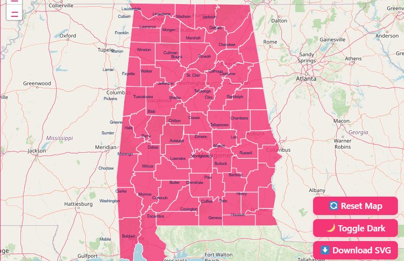
Alongside visual navigation, the map includes practical tools:
- Hover Highlight: Move your cursor across any county to clearly identify its boundaries.
- Labels Displayed on Map: Every county name appears directly on the map for quick reference.
- Zoom In & Out: Perfect for examining smaller counties or major metro areas with more detail.
- Dark Mode Toggle: Useful for nighttime viewing or high-contrast displays.
- Reset Button: Returns the view to the full Alabama state outline.
- Download Options (blank SVG & PNG): Export the map for presentations, school projects, genealogy, or planning documents.
Whether you’re a student researching local geography or a traveler planning a route, this interactive tool offers the easiest way to visualize Alabama’s full county structure.
Historical Overview of County Formation
The map of Alabama hasn’t always looked the way it does today. The formation of counties was a gradual process that mirrored the state’s settlement patterns and political history.
Early Divisions and the Treaty of Fort Jackson
The earliest county formation dates back to June 4, 1800, with the creation of Washington County.
At that time, the land was part of the Mississippi Territory. The landscape changed dramatically following the Treaty of Fort Jackson in 1814, which opened up vast territories to American settlers.
This influx of population necessitated a more structured local government, accelerating the creation of new counties.
Expansion and the Indian Removal Act
When Alabama was admitted to the Union as the 22nd state in 1819, it already had 29 counties.
The map continued to evolve as the state legislature formed additional counties from former native lands.
This was largely driven by the Indian Removal Act, which displaced Native American populations and opened further areas for settlement.
Timeline of Creation
The rapid growth of the state is evident in the timeline of county creation:
- 1820: 29 counties existed.
- 1830: The number grew to 36.
- 1840: 49 counties were established.
- 1850: The total reached 52.
- 1870: Post-Civil War adjustments brought the count to 65.
- 1903: The final map took shape with 67 counties.
Houston County, created on February 9, 1903, holds the distinction of being the last county formed in the state.
Since then, the constitution has effectively limited the creation of new counties by requiring a minimum land area of 600 square miles.
Geographical Overview of Alabama
Alabama’s geography plays a major role in shaping its county boundaries and regional identities.
The northern part of the state is dominated by the Appalachian foothills, featuring rugged terrain and elevated plateaus.
Moving southward, the land transitions into the Black Belt region, known for its rich dark soil and agricultural heritage.
Central Alabama contains rolling hills and river valleys, while the southernmost area opens onto the Gulf Coastal Plain, offering easy access to beaches, wetlands, and maritime habitats.
Key geographical features include:
- Tennessee River Valley: Vital for industry, agriculture, and settlement in the north.
- Coosa, Tallapoosa, and Alabama Rivers: Supporting ecosystems and communities across the state.
- Mobile Bay: A major shipping and fishing center shaping the counties of the Gulf Coast.
- Appalachian Plateau: Influences counties like Jackson, DeKalb, and Marshall.
This diverse physical landscape explains why Alabama’s counties vary greatly in size, shape, and historical development.
Key Features of an Alabama County Map
Modern maps of Alabama provide much more than just boundary lines. They are sophisticated tools that layer various types of data to provide a comprehensive view of the state.
Essential Elements
A standard political map will clearly display the 67 counties along with their county seats, the administrative centers where the courthouse is usually located.
For example, you will see Prattville identified as the seat of Autauga County, and Bay Minette for Baldwin County.
Major cities like Birmingham (Jefferson County), Huntsville (Madison County), and Montgomery (Montgomery County) serve as key landmarks for orientation.
Interactive Features
Digital mapping tools have revolutionized how we interact with geographical data. Platforms like Google Maps and specialized GIS (Geographic Information System) sites allow users to:
- Zoom and Pan: Explore specific regions in high detail or view the entire state at a glance.
- Draw and Measure: Calculate distances between towns or measure the area of specific plots of land.
- Overlay Data: Add layers for city limits, ZIP codes, and townships to see how administrative boundaries overlap.
Search Functionality
Most interactive maps now feature robust lookup tools. Users can type in a specific address or even GPS coordinates to instantly identify which county a location falls within.
This is particularly useful for real estate professionals or business owners determining tax jurisdictions.
Important Alabama County Insights
Largest Counties by Population
- Jefferson County: Alabama’s most populous and home to Birmingham.
- Mobile County: A southern coastal powerhouse with major port activity.
- Madison County: A growing tech and aerospace hub anchored by Huntsville.
Smallest Counties by Population
- Greene County, Perry County, and Wilcox County rank among the least populated, reflecting Alabama’s strong rural presence.
Regions Within the State
- North Alabama: Mountainous and known for aerospace and tech.
- Central Alabama: Mix of urban and rural landscapes.
- Black Belt Region: Historically agricultural, rich in cultural heritage.
- Gulf Coast Region: Tourism-driven and maritime focused.
Bordering States
Alabama borders:
- Tennessee to the north
- Georgia to the east
- Florida to the south
- Mississippi to the west
Major Highways Crossing Multiple Counties
- I-65: Runs north–south through 10+ counties.
- I-20/I-59: Connects Birmingham, Tuscaloosa, and the Mississippi border.
- US Route 231: Flows from north Alabama through Montgomery to the Florida line.
A Closer Look at Select Counties
While every county has its importance, a few stand out due to their population size, historical significance, or economic contribution.
Jefferson County
Home to Birmingham, Jefferson County is the most populous county in Alabama, with over 660,000 residents. It was established in 1819 and named after Thomas Jefferson.
Historically a powerhouse of iron and steel production, it remains a central economic hub for the state.
Mobile County
Located in the southwest corner of the state, Mobile County offers access to the Gulf of Mexico. Established in 1812, it is one of the oldest counties.
Its county seat, Mobile, is a historic port city known for having the oldest organized Carnival celebrations in the United States.
Madison County
In the north, Madison County is a center for technology and aerospace. Its county seat, Huntsville, is famously known as “Rocket City” due to the presence of NASA’s Marshall Space Flight Center.
Established in 1808, it is the third most populous county.
Baldwin County
Baldwin is the largest county by land area, covering over 1,590 square miles.
Located across the bay from Mobile, it is a major destination for tourism, boasting popular beach towns like Gulf Shores and Orange Beach.
The Importance of County Data
County-level data is a cornerstone for decision-making across various sectors.
Government and Planning
State and federal agencies rely on this data for resource allocation. Population statistics determine representation in the legislature and funding for schools and infrastructure.
Economic indicators help in planning development projects and attracting new industries.
Disaster Management
In times of crisis, such as hurricanes or tornadoes, county maps are vital for emergency response.
They help coordinate relief efforts, define evacuation zones, and track the path of storms across specific jurisdictions.
Business Insights
For the private sector, county data provides a roadmap for growth. Retailers use demographic information like average income and age distribution to decide where to open new stores.
Logistics companies use road networks and traffic data to optimize delivery routes.
List of Alabama Counties
Below is a complete table of all 67 counties in Alabama, including their FIPS code and county seat.
| County | FIPS Code | County Seat | Established |
| Autauga | 001 | Prattville | 1818 |
| Baldwin | 003 | Bay Minette | 1809 |
| Barbour | 005 | Clayton | 1832 |
| Bibb | 007 | Centreville | 1818 |
| Blount | 009 | Oneonta | 1818 |
| Bullock | 011 | Union Springs | 1866 |
| Butler | 013 | Greenville | 1819 |
| Calhoun | 015 | Anniston | 1832 |
| Chambers | 017 | LaFayette | 1832 |
| Cherokee | 019 | Centre | 1836 |
| Chilton | 021 | Clanton | 1868 |
| Choctaw | 023 | Butler | 1847 |
| Clarke | 025 | Grove Hill | 1812 |
| Clay | 027 | Ashland | 1866 |
| Cleburne | 029 | Heflin | 1866 |
| Coffee | 031 | Elba | 1841 |
| Colbert | 033 | Tuscumbia | 1867 |
| Conecuh | 035 | Evergreen | 1818 |
| Coosa | 037 | Rockford | 1832 |
| Covington | 039 | Andalusia | 1821 |
| Crenshaw | 041 | Luverne | 1866 |
| Cullman | 043 | Cullman | 1877 |
| Dale | 045 | Ozark | 1824 |
| Dallas | 047 | Selma | 1818 |
| DeKalb | 049 | Fort Payne | 1836 |
| Elmore | 051 | Wetumpka | 1866 |
| Escambia | 053 | Brewton | 1868 |
| Etowah | 055 | Gadsden | 1866 |
| Fayette | 057 | Fayette | 1824 |
| Franklin | 059 | Russellville | 1818 |
| Geneva | 061 | Geneva | 1868 |
| Greene | 063 | Eutaw | 1819 |
| Hale | 065 | Greensboro | 1867 |
| Henry | 067 | Abbeville | 1819 |
| Houston | 069 | Dothan | 1903 |
| Jackson | 071 | Scottsboro | 1819 |
| Jefferson | 073 | Birmingham | 1819 |
| Lamar | 075 | Vernon | 1867 |
| Lauderdale | 077 | Florence | 1818 |
| Lawrence | 079 | Moulton | 1818 |
| Lee | 081 | Opelika | 1866 |
| Limestone | 083 | Athens | 1818 |
| Lowndes | 085 | Hayneville | 1830 |
| Macon | 087 | Tuskegee | 1832 |
| Madison | 089 | Huntsville | 1808 |
| Marengo | 091 | Linden | 1818 |
| Marion | 093 | Hamilton | 1818 |
| Marshall | 095 | Guntersville | 1836 |
| Mobile | 097 | Mobile | 1812 |
| Monroe | 099 | Monroeville | 1815 |
| Montgomery | 101 | Montgomery | 1816 |
| Morgan | 103 | Decatur | 1818 |
| Perry | 105 | Marion | 1819 |
| Pickens | 107 | Carrollton | 1820 |
| Pike | 109 | Troy | 1821 |
| Randolph | 111 | Wedowee | 1832 |
| Russell | 113 | Phenix City | 1832 |
| St. Clair | 115 | Ashville & Pell City | 1818 |
| Shelby | 117 | Columbiana | 1818 |
| Sumter | 119 | Livingston | 1832 |
| Talladega | 121 | Talladega | 1832 |
| Tallapoosa | 123 | Dadeville | 1832 |
| Tuscaloosa | 125 | Tuscaloosa | 1818 |
| Walker | 127 | Jasper | 1823 |
| Washington | 129 | Chatom | 1800 |
| Wilcox | 131 | Camden | 1819 |
| Winston | 133 | Double Springs | 1850 |
Frequently Asked Questions
What is the largest county in Alabama?
Baldwin County is the largest by land area, covering approximately 1,590 square miles. It is located in the southwestern part of the state along the Gulf Coast.
What are the five largest counties in Alabama by population?
The most populated counties are Jefferson, Mobile, Madison, Montgomery, and Shelby. These counties contain Alabama’s largest cities and fastest-growing communities.
Which Alabama counties have the smallest land area?
Etowah, Hale, and Cherokee counties rank among the smallest in land area, though they remain important hubs for local governance and economic activity.
How many counties in Alabama touch the Gulf of Mexico?
Only two counties, Mobile County and Baldwin County sit along the Gulf Coast, making them essential for maritime trade, tourism, and seafood industries.
Can I use this Alabama county map for school or official projects?
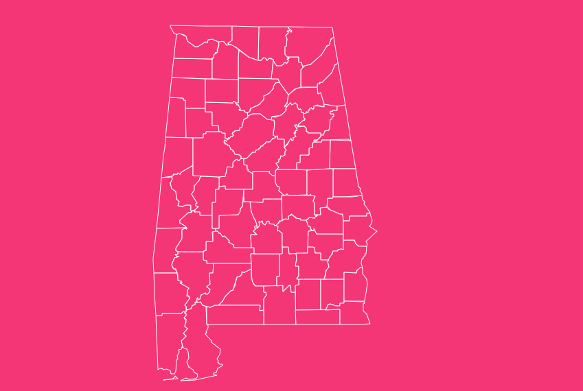
Yes. The PNG and SVG download options allow you to use the map in school assignments, presentations, or official documents. The SVG format is ideal for high-quality printing or graphic editing.
Which Alabama counties are part of the Appalachian region?
Northern counties such as Jackson, Madison, Marshall, DeKalb, and Blount fall within the Appalachian foothills, featuring elevated terrain, ridges, and scenic landscapes.
Discover the Heart of Alabama Through its Map
So, take a moment to explore Alabama county maps today, you might just discover a new corner of the state waiting to be explored.