Virginia isn’t just for lovers; it’s for map enthusiasts, history buffs, and data analysts, too. If you have ever looked at a map of Virginia, you might have noticed something strange.
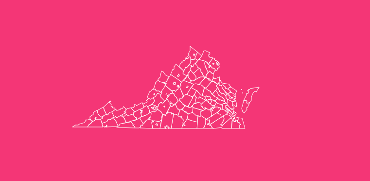
It’s not just a collection of jigsaw-puzzle counties like other states. Instead, it is a complex tapestry of counties and independent cities, creating a unique administrative geography found almost nowhere else in the United States.
Whether you are a student working on a geography project, a real estate agent analyzing regional markets, or a developer looking for raw SVG data, understanding the layout of the Old Dominion is crucial.
How to Use the Map Tool on This Page
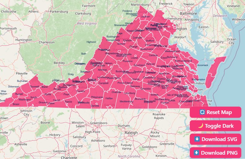
We have designed an interactive map experience to help you visualize Virginia’s unique geography. Here is how you can get the most out of the tools provided above:
Hover to Highlight
Move your cursor over any county or independent city to instantly see its name and boundary lines highlighted.
Zoom In and Out
Use the scroll wheel on your mouse or the + and – buttons in the map interface to get a closer look at high-density areas like Northern Virginia or the Hampton Roads region.
Dark Mode Toggle
Switch between light and dark modes to view the map in the contrast that best suits your current lighting or presentation needs.
Reset Button
Got lost in the Blue Ridge Mountains? Hit the reset button to return the map to its default statewide view.
Download Options
Need to take this data offline? We offer high-resolution downloads suitable for any project.
Blank Printable SVG
Ideal for graphic designers and developers who need scalable vector graphics that can be edited without losing quality.
High-Res PNG
Perfect for slide presentations, classroom handouts, or quick reference sheets.
Historical Overview of County Formation
Virginia’s county system is one of the oldest in the country, with roots stretching back to 1634. Originally, the Virginia Colony was divided into eight “shires” based on the English system.
These original shires, Accomack, Charles City, Charles River, Elizabeth City, Henrico, James City, Warrosquyoke, and Warwick River, formed the foundation of local government.
Over the centuries, as the population pushed westward past the Fall Line and into the Shenandoah Valley, these massive shires were subdivided into smaller counties to ensure that citizens could travel to their county seat and back within a single day by horse.
This historical fracturing explains why Virginia has such a high density of counties compared to Western states.
Geographical Overview of Virginia
Virginia’s geography is as diverse as its history, generally divided into five distinct physical regions that influence county borders and development:
Tidewater (Coastal Plain)
The easternmost region, characterized by flat land and numerous rivers flowing into the Chesapeake Bay. This area includes counties like Accomack and Northampton.
Piedmont
West of the Fall Line, this rolling hill country is home to the state’s central counties, including Albemarle and Buckingham.
Blue Ridge Mountains
A distinct, narrow line of mountains that forms the eastern wall of the Appalachian range, hosting counties like Floyd and Greene.
Valley and Ridge
This area includes the famous Shenandoah Valley and is known for its parallel ridges and fertile valleys, housing counties like Rockingham and Shenandoah.
Appalachian Plateau
The southwestern tip of the state, known for rugged terrain and coal deposits, includes counties like Dickenson and Buchanan.
Important Virginia County Insights
Virginia is administratively unique because of its system of independent cities.
Unlike in other states where cities are typically part of a county (e.g., Chicago is in Cook County), Virginia’s 38 independent cities are politically and administratively separate from the surrounding counties.
Unique Aspects of Independent Cities
Total Administrative Units
Virginia has 95 counties and 38 independent cities, totaling 133 local government units.
Separation of Power
Residents of independent cities pay taxes to the city, not the surrounding county, and elect a separate school board and city council.
Geography
Many independent cities, like Fairfax City, are enclaves entirely surrounded by a single county (Fairfax County), yet they remain legally distinct.
Key Facts and Statistics
- Largest County by Area: Pittsylvania County dominates the map with nearly 970 square miles of land.
- Smallest County by Area: Arlington County is the smallest at just 26 square miles (though it is densely populated).
- Most Populous: Fairfax County is an economic powerhouse with over 1.1 million residents.
- Least Populous: Highland County, often called “Little Switzerland,” has a population of just over 2,300 people.
Regional Breakdown of Virginia Counties
To better understand the state, it helps to group these 133 units into broader cultural and geographical regions.
Northern Virginia (NoVA)
This region is closely tied to the Washington D.C. metropolitan area. It is the most populous and affluent region.
- Key Counties: Fairfax, Loudoun, Prince William, Arlington.
- Characteristics: High-tech industry, federal government contractors, and dense suburban sprawl.
Central Virginia
Anchored by the state capital, Richmond, this region blends history with modern industry.
- Key Counties: Henrico, Chesterfield, Hanover.
- Characteristics: Historical tourism, finance, and logistics hubs.
Hampton Roads (Coastal Virginia)
Located at the mouth of the Chesapeake Bay, this area is defined by its water access.
- Key Counties/Cities: Virginia Beach, Norfolk, Chesapeake, York County.
- Characteristics: Massive military presence (Navy), shipping, and beach tourism.
Shenandoah Valley
The agricultural heart of the state, running along the I-81 corridor.
- Key Counties: Augusta, Rockingham, Frederick, Roanoke.
- Characteristics: Farming, higher education (JMU, Virginia Tech nearby), and manufacturing.
Southwest Virginia
The mountainous, rugged tail of the state.
- Key Counties: Wise, Washington, Smyth.
- Characteristics: Appalachian culture, music heritage, and natural resource extraction.
The Importance of County Data
Why does all this matter? Granular county data is the lifeblood of decision-making.
Commercial Projects
Businesses use county-level demographics to decide where to open new franchise locations or target marketing campaigns.
Educational Materials
Teachers use county maps to explain the Civil War, local government structures, and geography.
Real Estate
Agents rely on county tax maps and zoning laws to advise clients on property investments.
Public Policy
Government agencies allocate funding for roads, schools, and emergency services based on county-level census data.
List of Virginia Counties
Below is a detailed breakdown of Virginia’s counties, including their FIPS codes, county seats, and the year they were established.
| County Name | FIPS Code | County Seat | Established |
| Accomack | 51-001 | Accomac | 1663 |
| Albemarle | 51-003 | Charlottesville | 1744 |
| Alleghany | 51-005 | Covington | 1822 |
| Amelia | 51-007 | Amelia Court House | 1735 |
| Amherst | 51-009 | Amherst | 1761 |
| Appomattox | 51-011 | Appomattox | 1845 |
| Arlington | 51-013 | Arlington | 1801 |
| Augusta | 51-015 | Staunton | 1738 |
| Bath | 51-017 | Warm Springs | 1791 |
| Bedford | 51-019 | Bedford | 1754 |
| Bland | 51-021 | Bland | 1861 |
| Botetourt | 51-023 | Fincastle | 1770 |
| Brunswick | 51-025 | Lawrenceville | 1720 |
| Buchanan | 51-027 | Grundy | 1858 |
| Buckingham | 51-029 | Buckingham | 1761 |
| Campbell | 51-031 | Rustburg | 1782 |
| Caroline | 51-033 | Bowling Green | 1728 |
| Carroll | 51-035 | Hillsville | 1842 |
| Charles City | 51-036 | Charles City | 1634 |
| Charlotte | 51-037 | Charlotte Court House | 1765 |
| Chesterfield | 51-041 | Chesterfield | 1749 |
| Clarke | 51-043 | Berryville | 1836 |
| Craig | 51-045 | New Castle | 1851 |
| Culpeper | 51-047 | Culpeper | 1749 |
| Cumberland | 51-049 | Cumberland | 1749 |
| Dickenson | 51-051 | Clintwood | 1880 |
| Dinwiddie | 51-053 | Dinwiddie | 1752 |
| Essex | 51-057 | Tappahannock | 1692 |
| Fairfax | 51-059 | Fairfax | 1742 |
| Fauquier | 51-061 | Warrenton | 1759 |
| Floyd | 51-063 | Floyd | 1831 |
| Fluvanna | 51-065 | Palmyra | 1777 |
| Franklin | 51-067 | Rocky Mount | 1786 |
| Frederick | 51-069 | Winchester | 1738 |
| Giles | 51-071 | Pearisburg | 1806 |
| Gloucester | 51-073 | Gloucester | 1651 |
| Goochland | 51-075 | Goochland | 1728 |
| Grayson | 51-077 | Independence | 1793 |
| Greene | 51-079 | Stanardsville | 1838 |
| Greensville | 51-081 | Emporia | 1781 |
| Halifax | 51-083 | Halifax | 1752 |
| Hanover | 51-085 | Hanover | 1721 |
| Henrico | 51-087 | Richmond | 1634 |
| Henry | 51-089 | Martinsville | 1777 |
| Highland | 51-091 | Monterey | 1847 |
| Isle of Wight | 51-093 | Isle of Wight | 1634 |
| James City | 51-095 | Williamsburg | 1634 |
| King and Queen | 51-097 | King and Queen Court House | 1691 |
| King George | 51-099 | King George | 1721 |
| King William | 51-101 | King William | 1702 |
| Lancaster | 51-103 | Lancaster | 1651 |
| Lee | 51-105 | Jonesville | 1793 |
| Loudoun | 51-107 | Leesburg | 1757 |
| Louisa | 51-109 | Louisa | 1742 |
| Lunenburg | 51-111 | Lunenburg | 1746 |
| Madison | 51-113 | Madison | 1793 |
| Mathews | 51-115 | Mathews | 1791 |
| Mecklenburg | 51-117 | Boydton | 1765 |
| Middlesex | 51-119 | Saluda | 1673 |
| Montgomery | 51-121 | Christiansburg | 1777 |
| Nelson | 51-125 | Lovingston | 1808 |
| New Kent | 51-127 | New Kent | 1654 |
| Northampton | 51-131 | Eastville | 1634 |
| Northumberland | 51-133 | Heathsville | 1648 |
| Nottoway | 51-135 | Nottoway | 1789 |
| Orange | 51-137 | Orange | 1734 |
| Page | 51-139 | Luray | 1831 |
| Patrick | 51-141 | Stuart | 1791 |
| Pittsylvania | 51-143 | Chatham | 1767 |
| Powhatan | 51-145 | Powhatan | 1777 |
| Prince Edward | 51-147 | Farmville | 1754 |
| Prince George | 51-149 | Prince George | 1703 |
| Prince William | 51-153 | Manassas | 1731 |
| Pulaski | 51-155 | Pulaski | 1839 |
| Rappahannock | 51-157 | Washington | 1833 |
| Richmond | 51-159 | Warsaw | 1692 |
| Roanoke | 51-161 | Salem | 1838 |
| Rockbridge | 51-163 | Lexington | 1778 |
| Rockingham | 51-165 | Harrisonburg | 1778 |
| Russell | 51-167 | Lebanon | 1786 |
| Scott | 51-169 | Gate City | 1814 |
| Shenandoah | 51-171 | Woodstock | 1772 |
| Smyth | 51-173 | Marion | 1832 |
| Southampton | 51-175 | Courtland | 1749 |
| Spotsylvania | 51-177 | Spotsylvania Courthouse | 1721 |
| Stafford | 51-179 | Stafford | 1664 |
| Surry | 51-181 | Surry | 1652 |
| Sussex | 51-183 | Sussex | 1754 |
| Tazewell | 51-185 | Tazewell | 1800 |
| Warren | 51-187 | Front Royal | 1836 |
| Washington | 51-191 | Abingdon | 1777 |
| Westmoreland | 51-193 | Montross | 1653 |
| Wise | 51-195 | Wise | 1856 |
| Wythe | 51-197 | Wytheville | 1790 |
| York | 51-199 | Yorktown | 1634 |
Frequently Asked Questions
How many counties are in Virginia?
There are 95 counties in Virginia. However, when you include the 38 independent cities which function as county-equivalents, there are 133 total administrative units.
Why does Virginia have independent cities?
This system was formalized in the 1871 state constitution and refined in 1902. It was designed to prevent county governments from taxing city residents for services (like rural roads) that city dwellers did not use, and vice versa.
Which Virginia county has the largest population?
Fairfax County is the most populous, with over 1.16 million residents as of the 2024 census estimates.
What is the difference between a county and an independent city?
Independent cities are not part of any county. They have their own courts, school boards, and tax systems. Towns, conversely, are part of counties and residents pay taxes to both.
What are the “original 8 shires” of Virginia?
Established in 1634, they were Accomack, Charles City, Charles River (York), Elizabeth City, Henrico, James City, Warrosquyoake (Isle of Wight), and Warwick River.
Can independent cities revert to towns?
Yes. Several independent cities, such as South Boston (in 1995) and Clifton Forge (in 2001), have given up their city charters to become towns within their surrounding counties to consolidate services and reduce costs.
What is the “Fall Line” and how does it affect the map?
The Fall Line is a geological boundary where the Piedmont meets the Coastal Plain.
Many major cities (Richmond, Fredericksburg, Petersburg) were founded along this line because it was the furthest point ships could navigate upstream.
Is Arlington a city or a county?
Arlington is technically a county. However, because it is so small and entirely urbanized, it has no incorporated towns within it and functions much like a city.
What is the “Lost County” of Virginia?
There have been several extinct counties, but a notable one is Illinois County, which existed from 1778 to 1784 and covered a massive area of the modern Midwest before being ceded to the federal government.
Start Your Virginia Mapping Project Today
Don’t just look at the data, interact with it. Use the tools on this page to customize your view, download the high-resolution vector files for your next presentation, or print out a reference sheet for your classroom.
[Download Free Virginia Map Data Now].