When people think of New York, the bustling streets of Manhattan often dominate the imagination.
However, the Empire State is a massive, geographically diverse region spanning over 54,000 square miles, from the Great Lakes in the west to the tip of Long Island in the east.
Understanding this complex state requires more than just a road map; it requires a deep dive into its administrative heart: the county system.
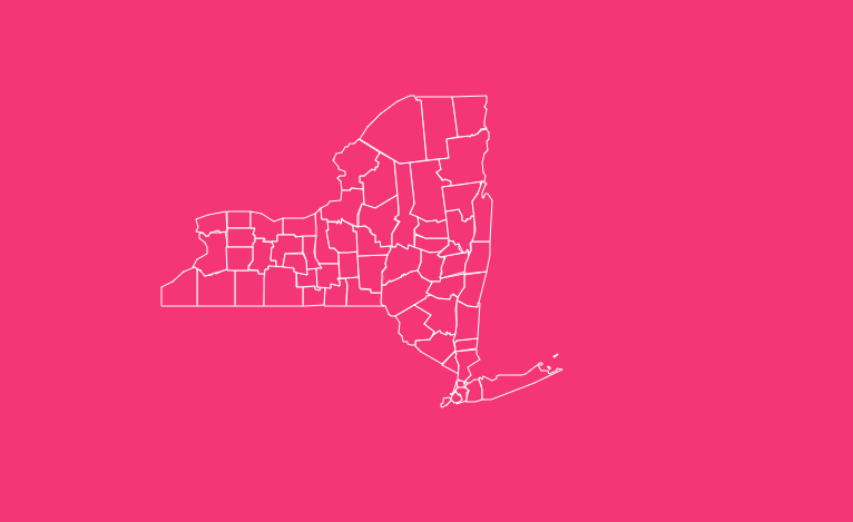
How to Use the Interactive Map Tool
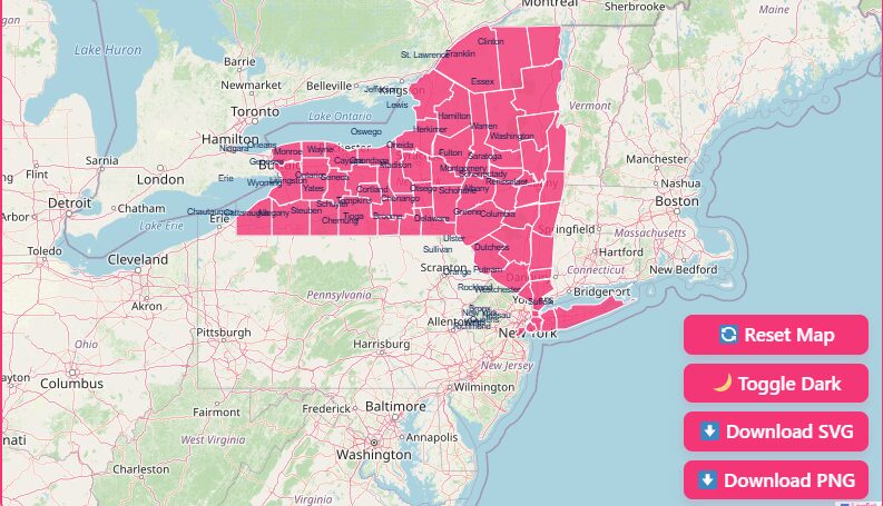
Hover Highlight
Simply move your mouse over any area of the map. The specific county will highlight, displaying its name and key data points immediately.
Zoom In/Out
Use the + and – buttons in the top corner (or use your mouse scroll wheel) to focus on dense areas like the New York City metropolitan area or zoom out for a statewide view.
Reset Button
If you get lost in the details, hit the “Reset” button to instantly return to the default statewide perspective.
Dark Mode Toggle
Switch between light and dark modes to view the map in the contrast setting that best suits your screen environment.
Download Options
Need a map for a project? You can download the current view in multiple formats:
- Blank SVG: Best for designers who need scalable vector graphics.
- PNG Image: High-resolution images perfect for slides and documents.
Historical Overview of County Formation
The history of New York’s counties is a reflection of the history of America itself, evolving from colonial rule to modern governance.
The Original 12 (1683)
The foundation of the state’s geography began in 1683. Shortly after the British took control of the Dutch colony of New Amsterdam, they established the first 12 counties.
While some of these boundaries have shifted (and two were later ceded to Massachusetts), many of these original names remain familiar today, including Albany, Kings, New York, Queens, Richmond, Suffolk, Ulster, and Westchester.
Expansion and Evolution
As settlers moved westward and populations grew, the state legislature carved out new counties from existing territories. This process continued throughout the 18th and 19th centuries.
19th Century Boom
Most of the counties we recognize today were established during the 1800s to manage local governance as the state’s population exploded.
The Newest County
The final piece of the puzzle was placed in 1914. Bronx County was created from portions of New York County that had been annexed from Westchester, solidifying the map we know today.
What’s in a Name?
The etymology of these counties paints a vivid picture of the state’s heritage:
Native American Roots
Many names, such as Chautauqua, Cayuga, and Erie, are derived from the languages of the Iroquois and other indigenous tribes.
British Royalty
Counties like Kings, Queens, and Dutchess honor the British monarchy that once ruled the colony.
Revolutionary Heroes
As independence took hold, new counties were named after American statesmen and generals, including Washington, Clinton, and Franklin.
Geographical Overview of New York
New York is often geographically conceptualized in two parts: “Upstate” and “Downstate,” though the definitions vary depending on who you ask.
Downstate
This area includes the five boroughs of New York City (Manhattan, Brooklyn, Queens, The Bronx, and Staten Island), Long Island (Nassau and Suffolk counties), and typically Westchester and Rockland counties.
This region is defined by high population density and coastal geography.
Upstate
This encompasses the vast majority of the state’s landmass.
It features the rugged Adirondack Mountains in the north (home to Essex and Clinton counties), the Finger Lakes region in the center (Cayuga, Seneca), and the Western frontier bordering the Great Lakes (Erie, Niagara).
The NYC Anomaly: Boroughs vs. Counties
One of the most confusing aspects of New York geography for outsiders is the relationship between New York City’s five boroughs and the county system.
In NYC, the boroughs and counties are coextensive, meaning they share the exact same boundaries. However, their functions are different from counties elsewhere in the state.
- Manhattan is New York County.
- Brooklyn is Kings County.
- The Bronx is Bronx County.
- Staten Island is Richmond County.
- Queens is Queens County.
Governance Note: Unlike other counties in New York that have their own legislatures and executives, these five counties have very limited power.
They are primarily governed by the centralized New York City government. While they elect Borough Presidents, these roles are largely ceremonial and advisory compared to a County Executive.
The counties do, however, retain their own District Attorneys and court systems.
Important New York County Insights
Analyzing the data across these 62 counties reveals stark contrasts:
Population Extremes
Kings County (Brooklyn) is the most populous, with over 2.6 million residents.
In sharp contrast, Hamilton County, located deep in the Adirondacks, has a population of just over 5,000, making it the least densely populated.
Size Matters
St. Lawrence County is the largest by area, covering a massive 2,821 square miles.
On the other end of the spectrum, New York County (Manhattan) covers only about 23 square miles of land yet serves as the economic engine of the region.
Economic Hubs
While NYC dominates the economy, upstate counties like Erie (Buffalo) and Monroe (Rochester) serve as critical industrial and educational hubs for Western New York.
Individual County Deep Dive
To understand the variety within the state, let’s look closer at a selection of specific counties, ranging from the capital to the Canadian border.
Albany County
- Significance: Created as one of the original 12 counties in 1683, it is the seat of the state government.
- Key Fact: It is home to Albany, the State Capital, making it the political center of New York.
Allegany County
- Name Origin: The name is a variant spelling of the Allegheny River.
- History: Formed in 1806, this county is known for its rolling hills and history in the oil and gas industry.
Bronx County
- Uniqueness: As the newest county (1914), it is the only NYC borough located primarily on the North American mainland (the others are on islands).
- Identity: It is culturally distinct and densely populated, serving as a vital northern gateway to the city.
Broome County
- Name Origin: Named in honor of John Broome, a Lieutenant Governor of New York.
- Hub: Its county seat, Binghamton, was once a manufacturing giant and remains a key educational hub.
Cattaraugus County
- Formation: When formed in 1808, it was provisionally annexed to Niagara County because it lacked enough voting residents to function independently.
- Name: Derived from an Iroquoian term meaning “bad smelling banks,” referring to the odor of natural gas leaking from rock seams.
Cayuga County
- Location: Situated in the heart of the Finger Lakes region.
- Name Origin: Named after the Cayuga tribe of the Iroquois Confederacy, the “People of the Great Swamp.”
Chautauqua County
- Name Origin: Named for Chautauqua Lake. The word is of Erie origin, though the exact translation is lost to history.
- Geography: It is the westernmost county in the state.
Chemung County
- Name Origin: Derived from a Native American village name meaning “big horn.”
- History: The name refers to the discovery of large mammoth tusks found in the Chemung River by indigenous people.
Chenango County
- Name Origin: Believed to be derived from an Onondaga term meaning “large bull-thistle.”
- Formation: The land was purchased from indigenous tribes in 1788 before becoming a county.
Clinton County
- Name Origin: Named in honor of George Clinton, the first Governor of New York and a U.S. Vice President.
- Geography: Located in the extreme northeast of the state, its southwest portion lies within the protected Adirondack Park.
The Importance of County Data
Why does visualizing county data matter?
Policy Making
State funds are often distributed based on county-level data regarding population, health outcomes, and infrastructure needs.
Business Strategy
Companies use county demographics to decide where to open new branches, launch marketing campaigns, or recruit talent.
Real Estate
Trends in housing prices are highly localized. Understanding the distinction between Westchester County taxes and Putnam County prices can save homebuyers thousands.
List of New York Counties
The following table provides data on a selection of New York’s counties, including the “Original 12” and other notable regions discussed in this guide.
| County Name | FIPS Code | County Seat | Established | Notes |
| Albany | 36001 | Albany | 1683 | Original 12 County |
| Allegany | 36003 | Belmont | 1806 | Named for Allegheny River |
| Bronx | 36005 | N/A (Borough) | 1914 | Coextensive with The Bronx |
| Broome | 36007 | Binghamton | 1806 | Named for John Broome |
| Cattaraugus | 36009 | Little Valley | 1808 | Known for natural gas history |
| Cayuga | 36011 | Auburn | 1799 | Finger Lakes region |
| Chautauqua | 36013 | Mayville | 1808 | Westernmost county |
| Chemung | 36015 | Elmira | 1836 | Named for “Big Horn” |
| Chenango | 36017 | Norwich | 1798 | “Land of Bullthistle” |
| Clinton | 36019 | Plattsburgh | 1788 | Borders Canada |
| Dutchess | 36027 | Poughkeepsie | 1683 | Original 12 County |
| Erie | 36029 | Buffalo | 1821 | Home to Buffalo |
| Kings | 36047 | N/A (Borough) | 1683 | Coextensive with Brooklyn |
| Monroe | 36055 | Rochester | 1821 | Home to Rochester |
| New York | 36061 | N/A (Borough) | 1683 | Coextensive with Manhattan |
| Orange | 36071 | Goshen | 1683 | Original 12 County |
| Queens | 36081 | N/A (Borough) | 1683 | Coextensive with Queens |
| Richmond | 36085 | N/A (Borough) | 1683 | Coextensive with Staten Island |
| St. Lawrence | 36089 | Canton | 1802 | Largest by area |
| Suffolk | 36103 | Riverhead | 1683 | Original 12 County |
| Ulster | 36111 | Kingston | 1683 | Original 12 County |
| Westchester | 36119 | White Plains | 1683 | Original 12 County |
Frequently Asked Questions
How many counties are in New York State?
There are exactly 62 counties in New York State.
Which New York county is the largest by size?
St. Lawrence County is the largest, covering approximately 2,821 square miles.
Which New York county has the highest population?
Kings County (Brooklyn) is the most populous, with over 2.6 million residents.
What is the FIPS code prefix for New York counties?
All New York county FIPS codes begin with the state identifier “36” followed by a three-digit county code (e.g., Albany is 36001).
Are the boroughs of NYC considered counties?
Yes. Each of the five boroughs is coextensive with a county: Bronx (Bronx), Brooklyn (Kings), Manhattan (New York), Queens (Queens), and Staten Island (Richmond).
Do NYC counties have the same government power as upstate counties?
No. NYC counties have very limited powers and do not have functioning county governments; they are governed primarily by the City of New York.
What was the first county established in New York?
Twelve counties were established simultaneously on November 1, 1683. These include Albany, Dutchess, Kings, New York, Orange, Queens, Richmond, Suffolk, Ulster, and Westchester.
Which county is the newest?
Bronx County is the newest, established in 1914.
What is the smallest county in New York?
New York County (Manhattan) is the smallest by land area, measuring roughly 23 square miles.
Conclusion
Whether you are mapping demographic trends or simply exploring the rich history of the Empire State, understanding the county map is essential.
Ready to dive deeper into the data? Start using the interactive map above to visualize the state like never before, or download your own copy to start your research today.