New Jersey might be the fourth-smallest state by land area, but it packs a punch when it comes to density, diversity, and administrative complexity.
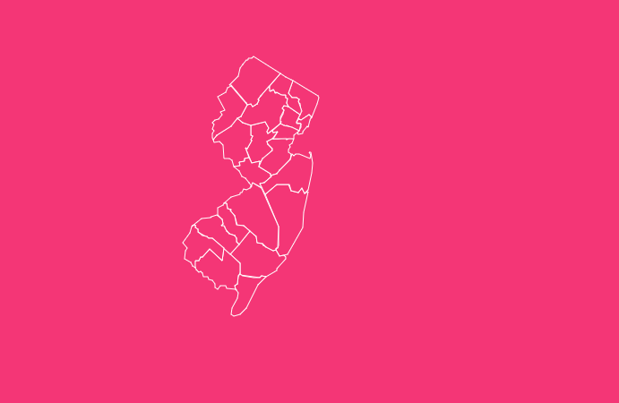
Divided into 21 unique counties, the “Garden State” ranges from the bustling, skyline-filled streets of Hudson County to the rolling farmlands of Salem.
Whether you are a researcher looking for FIPS codes, a business owner analyzing regional demographics, or a resident curious about local history, understanding the layout of New Jersey is essential.
How to Use the Tool on This Page
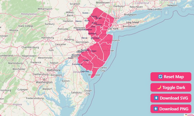
We have designed our interactive map to be as user-friendly as possible, allowing you to visualize data effectively. Here is how to get the most out of the experience:
Hover Highlights
Simply move your mouse (or tap, on mobile) over any county to see an instant popup containing the county name, seat, and population density.
Zoom In and Out
Use the + and – buttons in the top right corner or use the scroll wheel on your mouse to focus on specific regions like the New York metropolitan area or the Delaware Valley.
Dark Mode Toggle
Working late? Switch the map interface to dark mode using the toggle in the settings menu to reduce eye strain.
Reset Button
If you get lost in the details, hit the “Reset View” button to return to the full state perspective.
Download Options
Need a map for a presentation, a classroom assignment, or a report? We offer several high-resolution formats suitable for both digital and print use.
- Blank Printable Map: A clean, outline-only version perfect for quizzes or coloring.
- SVG (Scalable Vector Graphics): Ideal for graphic designers who need to edit boundary lines or change colors without losing quality.
- PNG: A high-quality standard image file ready for insertion into Word documents or PowerPoint presentations.
Geographical Overview of New Jersey
New Jersey is a peninsula, bordered by water on all sides except the north. This unique geography dictates the shape and function of its counties.
The state is generally divided into three informal regions, though the exact lines are often debated by locals:
North Jersey
Economically and culturally tied to New York City. This includes counties like Bergen, Hudson, and Passaic. It features high population density and extensive public transit.
Central Jersey
The transition zone contains counties like Middlesex, Mercer, and Somerset. This area features a mix of suburban sprawl, corporate headquarters, and academic institutions like Princeton and Rutgers.
South Jersey
Culturally influenced by Philadelphia. This includes the Delaware Valley counties (Camden, Burlington, Gloucester) and the coastal “Shore” counties (Atlantic, Cape May).
Understanding these regions is vital for interpreting the county map, as infrastructure and economic focus shift drastically from the industrial north to the agricultural and tourism-focused south.
History of County Formation
The boundaries you see today are the result of centuries of division, consolidation, and negotiation.
In the late 1600s, New Jersey was governed as two distinct provinces: East Jersey and West Jersey.
The earliest counties were formed as administrative districts to manage courts and taxes within these provinces.
The Originals (1683)
East Jersey established Bergen, Essex, Middlesex, and Monmouth counties.
The West Jersey Expansion (1681-1694)
Burlington and Salem were the initial administrative centers for the western province.
The Final Piece (1857)
The map remained in flux for over a century. As populations grew, large counties were split to make governance manageable. The final county to be added was Union County, carved out of Essex County in 1857.
Legend has it that it was named “Union” to express support for the United States during the tense years leading up to the Civil War.
County Government Structure: A 2021 Update
If you are looking at older maps or government documents, you might see the term “Board of Chosen Freeholders.” This terminology is no longer accurate.
For centuries, New Jersey was the only state in the U.S. to use the term “Freeholder” for its county legislators, a term dating back to a time when only white male property owners could hold office.
Effective January 1, 2021, Governor Phil Murphy signed legislation abolishing this title. Today, the governing body of each county is officially known as the Board of County Commissioners.
When researching county data or attending public meetings, ensure you use the modern terminology to ensure accuracy in your reports.
List of New Jersey Counties
Below is a detailed look at the 21 counties that make up the state. We have highlighted key counties often sought after for demographic and economic analysis.
Atlantic County
Located in the southeast, Atlantic County is synonymous with Atlantic City. While tourism and gaming are major economic drivers, the county also features vast pine barrens and agricultural areas inland.
- County Seat: Mays Landing
- Known For: The Boardwalk, casinos, and Stockton University.
Bergen County
Sitting in the northeastern corner, Bergen is the most populous county in the state.
It serves as a major suburban hub for New York City commuters and is known for its strict “Blue Laws,” which ban retail shopping on Sundays, a unique anomaly in the US.
- County Seat: Hackensack
- Known For: Retail (shopping malls), proximity to NYC, and high property values.
Burlington County
This is the largest county by land area. It stretches all the way from the Delaware River near Philadelphia across the state to the Great Bay on the Atlantic coast.
It contains a significant portion of the Pine Barrens and Joint Base McGuire-Dix-Lakehurst.
- County Seat: Mount Holly
- Known For: Cranberry bogs, military bases, and historic colonial towns.
Camden County
Located directly across the river from Philadelphia, Camden County is a mix of dense urban areas and sprawling suburbs. It is a key transportation hub connecting South Jersey to Pennsylvania.
- County Seat: Camden
- Known For: The Adventure Aquarium, Rutgers-Camden, and the Ben Franklin Bridge.
Cape May County
The southernmost tip of the state, this county is a peninsula defined by its tourism industry. During the summer, the population swells significantly as visitors flock to the beaches.
- County Seat: Cape May Court House
- Known For: Victorian architecture, pristine beaches, and the Cape May Zoo.
Cumberland County
Located on the Delaware Bay, Cumberland is known for its rural character and glass-making history. It is part of the state’s agricultural heartland.
- County Seat: Bridgeton
- Known For: Agriculture, silica sand mining, and the Millville Arts District.
Essex County
Home to Newark, the state’s largest city, Essex is a hub of transportation, including Newark Liberty International Airport and the Port of Newark. It is densely populated and culturally diverse.
- County Seat: Newark
- Known For: Cherry Blossom Festival at Branch Brook Park, Prudential Center, and major transit lines.
Hudson County
The smallest county by area but the most densely populated.
It is essentially an extension of the New York City urban core, featuring skyscrapers, high-rise apartments, and the entrance to the Holland and Lincoln Tunnels.
- County Seat: Jersey City
- Known For: Liberty State Park, Hoboken waterfront, and urbanization.
Important New Jersey County Insights
When analyzing the map, specific outliers stand out in the data. Here are the key superlatives for the state’s geography:
Largest County (Area)
Burlington County (805 sq miles). Its massive size is largely due to the protected Pine Barrens which restricts development in the center of the county.
Smallest County (Area)
Hudson County (47 sq miles). Despite its size, it packs over 700,000 residents into its borders.
Most Populous
Bergen County (~955,000 residents).
Least Populous
Salem County (~65,000 residents). Salem maintains a quiet, rural atmosphere distinct from the rest of the state.
Oldest Counties
Bergen, Essex, Middlesex, and Monmouth were all established in 1683.
The Importance of County Data
Why does this map matter? In New Jersey, “Home Rule” is strong, but counties play a critical role in regional administration.
Taxation
County taxes fund community colleges, vocational schools, and expansive park systems.
Courts
The Superior Court system is organized by county.
Elections
Voter registration and election administration are handled at the county level (via the County Clerk and Board of Elections).
Real Estate
Property deeds and mortgages are recorded with the County Clerk.
FIPS codes are essential for mortgage lenders and insurance adjusters to accurately identify property locations for flood zones and tax liabilities.
Complete Data Table of New Jersey Counties
The following table provides the essential codes and historical data for all 21 counties.
The FIPS Code is a unique identifier used by the Census Bureau; for New Jersey, the state prefix is 34, followed by the three-digit county code.
| County Name | FIPS Code | County Seat | Established Year |
| Atlantic County | 34001 | Mays Landing | 1837 |
| Bergen County | 34003 | Hackensack | 1683 |
| Burlington County | 34005 | Mount Holly | 1694 |
| Camden County | 34007 | Camden | 1844 |
| Cape May County | 34009 | Cape May Court House | 1692 |
| Cumberland County | 34011 | Bridgeton | 1748 |
| Essex County | 34013 | Newark | 1683 |
| Gloucester County | 34015 | Woodbury | 1686 |
| Hudson County | 34017 | Jersey City | 1840 |
| Hunterdon County | 34019 | Flemington | 1714 |
| Mercer County | 34021 | Trenton | 1838 |
| Middlesex County | 34023 | New Brunswick | 1683 |
| Monmouth County | 34025 | Freehold Borough | 1683 |
| Morris County | 34027 | Morristown | 1739 |
| Ocean County | 34029 | Toms River | 1850 |
| Passaic County | 34031 | Paterson | 1837 |
| Salem County | 34033 | Salem | 1694 |
| Somerset County | 34035 | Somerville | 1688 |
| Sussex County | 34037 | Newton | 1753 |
| Union County | 34039 | Elizabeth | 1857 |
| Warren County | 34041 | Belvidere | 1824 |
Frequently Asked Questions
How many counties are in New Jersey?
There are 21 counties in New Jersey.
What is the largest county in NJ by size?
Burlington County is the largest by land area, covering approximately 805 square miles.
What is the smallest county in NJ?
Hudson County is the smallest by land area, covering just 47 square miles, yet it is one of the most densely populated.
Which NJ county has the highest population?
Bergen County has the highest population, with nearly 1 million residents.
What happened to the Board of Chosen Freeholders?
On January 1, 2021, the title “Freeholder” was officially changed to “County Commissioner” to update archaic language. The board is now called the Board of County Commissioners.
What is the FIPS state code for New Jersey?
The state FIPS code for New Jersey is 34. All county codes start with 34 (e.g., Atlantic County is 34001).
Which is the newest county in New Jersey?
Union County is the newest, established in 1857 from parts of Essex County.
Are New Jersey counties divided into townships?
Yes, New Jersey counties are subdivided into municipalities, which can be designated as cities, towns, townships, boroughs, or villages.
Which counties are considered “The Jersey Shore”?
The primary Jersey Shore counties are Monmouth, Ocean, Atlantic, and Cape May.
Where is the state capital located?
The state capital, Trenton, is located in Mercer County.
Conclusion
Whether you are using our map tool for a school project, market research, or simply to plan your next road trip, we hope this guide has provided the context you need.
Ready to dive deeper into local data? Start exploring our interactive map above or download your preferred version to get started today.