Montana, often called “Big Sky Country,” is a land of vast open spaces, rugged mountains, and rolling plains.
Navigating this massive landscape which covers over 147,040 square miles requires a solid understanding of its internal boundaries.
Whether you are a researcher analyzing demographic data, a traveler planning a road trip through the Rockies, or a business owner looking into zoning laws, having access to a reliable Montana state map with counties is essential.
How to Use the Map Tool on This Page
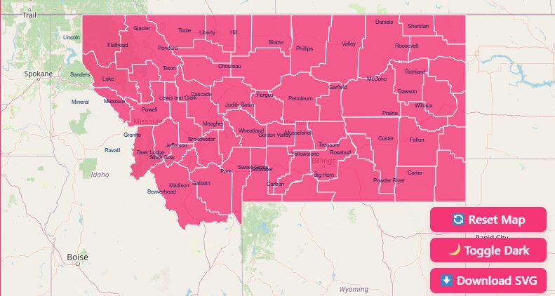
Hover and Highlight
Simply move your mouse cursor over any county to instantly highlight its border. This will display a tooltip with the county name and key statistics.
Zoom In and Out
Use the + and – buttons in the top corner of the map (or your mouse scroll wheel) to focus on specific regions, such as the crowded western valleys or the expansive eastern plains.
Reset Button
Got too deep into the map details? Click the reset button to return the view to the full state perspective immediately.
Dark Mode Toggle
If you are working late or prefer high-contrast visuals, switch the toggle to “Dark Mode” for a view that is easier on the eyes.
Download Options
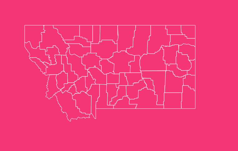
Need a hard copy? You can export the current view. We offer Blank Printable SVG and PNG formats, perfect for classroom quizzes, presentations, or offline reference.
Geographical Overview of Montana
Montana is the fourth-largest state in the United States by area, but it remains one of the least densely populated. This creates a unique administrative challenge: managing vast territories with relatively few residents.
The state is geographically divided into two distinct regions:
- The Western Third: Dominated by the Rocky Mountains, this area contains the Continental Divide and is home to the state’s fastest-growing population centers.
- The Eastern Two-Thirds: This region consists of the Great Plains/Northern Plains, characterized by agriculture, ranching, and energy production.
Montana borders the Canadian provinces of British Columbia, Alberta, and Saskatchewan to the north, North Dakota and South Dakota to the east, Wyoming to the south, and Idaho to the west and southwest.
Historical Overview of County Formation
The map of Montana hasn’t always looked the way it does today. The formation of these 56 counties is a story of political evolution, mining booms, and homesteading.
The Original Nine
On May 26, 1864, the Territory of Montana was established. Shortly after, on February 2, 1865, the first territorial legislature created the original nine counties:
- Beaverhead
- Big Horn
- Chouteau
- Deer Lodge
- Gallatin
- Jefferson
- Lewis and Clark (originally Edgerton)
- Madison
- Missoula
The Homestead Boom
Between 1910 and 1925, a massive influx of homesteaders led to a demand for smaller, more accessible government centers.
During this “county splitting” era, huge counties were carved up into smaller jurisdictions to ensure that farmers and ranchers could travel to their county seat and back in a single day by horse and wagon.
The Final Map
The frenzy of county creation ended in the 1920s. Petroleum County was the final county established, forming in 1925.
Since then, the number of counties has remained stable at 56, though some city-county governments (like Anaconda-Deer Lodge and Butte-Silver Bow) have consolidated operations.
Why is County Data Important?
Understanding county lines goes beyond simple geography. In Montana, the county is the primary unit of local government and data organization.
License Plates
Historically, Montana license plates began with a number prefix corresponding to the county’s population rank at the time. (e.g., ‘1’ for Silver Bow, ‘3’ for Yellowstone). Locals still identify cars by these numbers.
Resource Management
With diverse industries ranging from copper mining in Silver Bow to wheat farming in Chouteau, county-level data is crucial for allocating state resources.
Election Districts
County boundaries determine legislative representation and voting precincts.
Detailed List of Montana Counties
The table below provides a complete reference for all 56 counties, including their Federal Information Processing Standard (FIPS) codes, county seats, and the year they were established.
| County Name | FIPS Code | County Seat | Established |
| Beaverhead | 30001 | Dillon | 1865 |
| Big Horn | 30003 | Hardin | 1913 |
| Blaine | 30005 | Chinook | 1912 |
| Broadwater | 30007 | Townsend | 1897 |
| Carbon | 30009 | Red Lodge | 1895 |
| Carter | 30011 | Ekalaka | 1917 |
| Cascade | 30013 | Great Falls | 1887 |
| Chouteau | 30015 | Fort Benton | 1865 |
| Custer | 30017 | Miles City | 1865 |
| Daniels | 30019 | Scobey | 1920 |
| Dawson | 30021 | Glendive | 1869 |
| Deer Lodge | 30023 | Anaconda | 1865 |
| Fallon | 30025 | Baker | 1913 |
| Fergus | 30027 | Lewistown | 1885 |
| Flathead | 30029 | Kalispell | 1893 |
| Gallatin | 30031 | Bozeman | 1865 |
| Garfield | 30033 | Jordan | 1919 |
| Glacier | 30035 | Cut Bank | 1919 |
| Golden Valley | 30037 | Ryegate | 1920 |
| Granite | 30039 | Philipsburg | 1893 |
| Hill | 30041 | Havre | 1912 |
| Jefferson | 30043 | Boulder | 1865 |
| Judith Basin | 30045 | Stanford | 1920 |
| Lake | 30047 | Polson | 1923 |
| Lewis and Clark | 30049 | Helena | 1865 |
| Liberty | 30051 | Chester | 1920 |
| Lincoln | 30053 | Libby | 1909 |
| Madison | 30057 | Virginia City | 1865 |
| McCone | 30055 | Circle | 1919 |
| Meagher | 30059 | White Sulphur Springs | 1867 |
| Mineral | 30061 | Superior | 1914 |
| Missoula | 30063 | Missoula | 1865 |
| Musselshell | 30065 | Roundup | 1911 |
| Park | 30067 | Livingston | 1887 |
| Petroleum | 30069 | Winnett | 1925 |
| Phillips | 30071 | Malta | 1915 |
| Pondera | 30073 | Conrad | 1919 |
| Powder River | 30075 | Broadus | 1919 |
| Powell | 30077 | Deer Lodge | 1901 |
| Prairie | 30079 | Terry | 1915 |
| Ravalli | 30081 | Hamilton | 1893 |
| Richland | 30083 | Sidney | 1914 |
| Roosevelt | 30085 | Wolf Point | 1919 |
| Rosebud | 30087 | Forsyth | 1901 |
| Sanders | 30089 | Thompson Falls | 1905 |
| Sheridan | 30091 | Plentywood | 1913 |
| Silver Bow | 30093 | Butte | 1881 |
| Stillwater | 30095 | Columbus | 1913 |
| Sweet Grass | 30097 | Big Timber | 1895 |
| Teton | 30099 | Choteau | 1893 |
| Toole | 30101 | Shelby | 1914 |
| Treasure | 30103 | Hysham | 1919 |
| Valley | 30105 | Glasgow | 1893 |
| Wheatland | 30107 | Harlowton | 1917 |
| Wibaux | 30109 | Wibaux | 1914 |
| Yellowstone | 30111 | Billings | 1883 |
Exploring Montana’s Key Counties
While every county has a story, a few stand out due to their size, population, or historical significance.
Yellowstone County
Home to Billings, the state’s largest city, this is the economic engine of eastern Montana.
Lewis and Clark County
This county houses Helena, the state capital. It was one of the original counties and was named after the famous explorers.
Beaverhead County
Located in the southwest corner, this is the largest county by land area. It is known for its high-country ranching and blue-ribbon trout streams.
Silver Bow County
Conversely, this is the smallest county by land area. It is home to Butte, once known as the “Richest Hill on Earth” due to its massive copper deposits.
Frequently Asked Questions
How many counties are in Montana?
There are 56 counties in Montana.
Which is the largest county in Montana by area?
Beaverhead County is the largest, covering approximately 5,543 square miles.
Which is the smallest county in Montana by area?
Silver Bow County is the smallest, covering just over 718 square miles.
Which Montana county has the highest population?
Yellowstone County, home to the city of Billings, is the most populous.
Which Montana county has the lowest population?
Petroleum County is the least populous, often recording fewer than 500 residents in census data.
When was the last county formed in Montana?
Petroleum County was the last to be established, officially forming in 1925.
Which county contains the state capital?
Lewis and Clark County contains the state capital, Helena.
What are the “original nine” counties?
Established in 1865, they are Beaverhead, Big Horn, Chouteau, Deer Lodge, Gallatin, Jefferson, Lewis and Clark, Madison, and Missoula.
Why does Montana have so many counties with small populations?
During the homestead boom (1910-1920), counties were split to ensure rural farmers could travel to their county seat and back in one day by horse.
What is the FIPS code prefix for Montana?
All Montana county FIPS codes begin with 30 (e.g., 30001 for Beaverhead).
Start Your Research Today
Whether you are plotting a route through the Rockies or conducting demographic research, accurate map data is your best tool.
Use the interactive features above to customize your view, or download the blank maps for your own projects.
Ready to get started? Scroll up to the tool and download your first blank SVG map of Montana today.