When you look at a map of Massachusetts, you aren’t just seeing administrative lines; you’re looking at nearly 400 years of history.
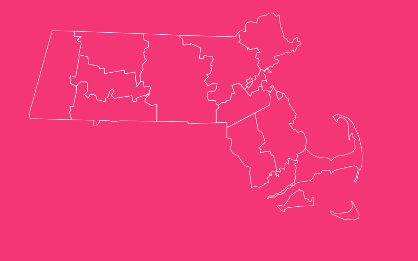
From the sandy shores of Barnstable to the rolling hills of the Berkshires, the “Bay State” is divided into 14 distinct counties, each with its own character, history, and geography.
Whether you are a real estate agent analyzing market trends, a student researching New England geography, or a genealogist tracing family roots, understanding these boundaries is essential.
How to Use the Massachusetts County Map Tool
Hover to Highlight
Move your cursor over any county to instantly highlight its boundary and view its name.
Zoom In and Out
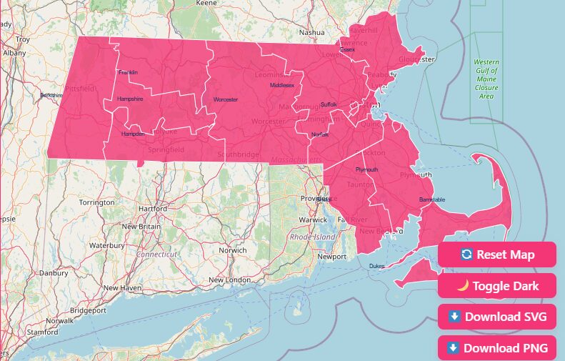
Use the + and – buttons in the top corner (or scroll with your mouse) to focus on specific regions like the Greater Boston area or the islands.
Reset Map
If you get lost in the details, hit the “Reset” button to return to the default statewide view.
Dark Mode
Prefer a high-contrast look? Toggle “Dark Mode” to switch the background visualization, which is often easier on the eyes for data analysis.
Download Options
Need a map for a presentation or report? Use the “Download” button to save the current view as a high-quality SVG (for editing) or PNG (for images).
Overview of Massachusetts Counties
Massachusetts is relatively small in size but dense in population and history. The state is divided into 14 counties.
While counties in most US states serve as strong regional governments, Massachusetts is unique. Between 1997 and 2000, eight of these 14 counties had their governments abolished.
In these areas, the “county” exists primarily as a geographical district for the court system and for tracking land records (Registry of Deeds), rather than as a legislative body.
List of Massachusetts Counties
The following table provides the essential data for all 14 counties, including their Federal Information Processing Standard (FIPS) codes, which are vital for data analysis.
| County Name | FIPS Code | County Seat (Shire Town) | Year Established |
| Barnstable | 25001 | Barnstable | 1685 |
| Berkshire | 25003 | Pittsfield | 1761 |
| Bristol | 25005 | Taunton | 1685 |
| Dukes | 25007 | Edgartown | 1695 |
| Essex | 25009 | Salem / Lawrence | 1643 |
| Franklin | 25011 | Greenfield | 1811 |
| Hampden | 25013 | Springfield | 1812 |
| Hampshire | 25015 | Northampton | 1662 |
| Middlesex | 25017 | Lowell / Cambridge | 1643 |
| Nantucket | 25019 | Nantucket | 1695 |
| Norfolk | 25021 | Dedham | 1793 |
| Plymouth | 25023 | Plymouth / Brockton | 1685 |
| Suffolk | 25025 | Boston | 1643 |
| Worcester | 25027 | Worcester | 1731 |
Geographical Overview of Massachusetts
To understand the map, you must understand the land. Massachusetts is geographically diverse, generally divided into three sections:
Eastern Massachusetts
This includes the coastal plains, the “hook” of Cape Cod (Barnstable County), and the islands (Dukes and Nantucket).
It is the most densely populated region, dominated by the Greater Boston area (Suffolk, Middlesex, Essex, Norfolk).
Central Massachusetts
Dominated by Worcester County, this area features rolling hills and serves as a transition zone between the urban east and rural west.
Western Massachusetts
Comprising Berkshire, Franklin, Hampshire, and Hampden counties, this region is known for the Connecticut River Valley and the Berkshire Mountains. It is more rural and scenic, famous for fall foliage and agriculture.
Detailed Exploration of Each County
Let’s take a closer look at what makes each of these 14 counties unique.
Barnstable County
Known globally as Cape Cod, Barnstable County coincides entirely with the Cape Cod peninsula. It formed in 1685 and is famous for its sandy beaches, lighthouses, and maritime history.
Unlike many other MA counties, Barnstable retains a functioning regional government to manage the unique environmental needs of the Cape.
Berkshire County
Located on the far western edge of the state, bordering New York, this county is synonymous with the Berkshires.
It is a cultural hub known for Tanglewood (the summer home of the Boston Symphony Orchestra) and stunning mountain ranges. The county government was abolished in 2000.
Bristol County
Sitting in the southeastern part of the state, Bristol County borders Rhode Island. It has a rich industrial history, particularly in cities like Fall River and New Bedford, the latter of which was once the whaling capital of the world.
Dukes County
This county consists of Martha’s Vineyard, the Elizabeth Islands, and several smaller islands. It does not include Nantucket.
It is one of the few counties that still has an active county government. It is accessible only by boat or air, making it a premier summer destination.
Essex County
North of Boston lies Essex County, extending to the New Hampshire border. Established in 1643, it is one of the original counties.
It is famous for the maritime heritage of Gloucester and the historical significance of Salem, known for the witch trials of 1692.
Franklin County
The most rural county in mainland Massachusetts, Franklin County is located in the upper Connecticut River Valley.
It is known for agriculture, historic Deerfield, and the scenic Mohawk Trail. Its government was abolished in 1997.
Hampden County
Located south of Franklin and Hampshire counties, Hampden borders Connecticut. It is anchored by Springfield, the third-largest city in Massachusetts and the birthplace of basketball.
Hampshire County
Sandwiched between Franklin and Hampden, Hampshire County is home to the “Five Colleges” consortium (including UMass Amherst and Smith College).
It has a vibrant, intellectual culture centered around its shire town, Northampton.
Middlesex County
If you look for the economic engine of the state, you will find it here. Middlesex is the most populous county in Massachusetts (and New England).
It includes Cambridge (home to Harvard and MIT) and the tech hubs along Route 128. Its government was abolished in 1997, but it remains a critical statistical area.
Nantucket County
Nantucket is unique: it is a town, a county, and an island all in one. Located 30 miles off the coast of Cape Cod, it is the smallest county by land area and population. It operates with a consolidated town-county government.
Norfolk County
Norfolk is known as the “County of Presidents,” being the birthplace of John Adams, John Quincy Adams, John F. Kennedy, and George H.W. Bush.
Geographically, it is unusual because it has an exclave: the towns of Cohasset and Brookline are separated from the rest of the county.
Plymouth County
History lives here. Established in 1685, this county includes the site of the Plymouth Colony settlement of 1620. It covers the southeastern coast and is known for its cranberry bogs and the city of Brockton.
Suffolk County
Suffolk is the urban core of Massachusetts. It encompasses Boston, Chelsea, Revere, and Winthrop.
Despite being the economic capital, the county government was abolished in 1999, meaning the City of Boston handles most administrative functions.
Worcester County
Stretching across the center of the state, Worcester is the largest county by area. It serves as the bridge between the Boston metro area and Western Mass.
The city of Worcester is the second-largest city in New England, undergoing a significant cultural and economic renaissance.
Historical Overview of County Formation
Understanding the Massachusetts county map requires looking back to the colonial era.
1643
The Massachusetts Bay Colony created the first four counties: Essex, Middlesex, Suffolk, and “Old Norfolk” (which was later absorbed by New Hampshire and Essex).
1685
The Plymouth Colony was divided into Barnstable, Bristol, and Plymouth counties.
1812
Hampden was the last county to be established, split off from Hampshire county due to population growth in the Connecticut River Valley.
The Great Abolishment
In the late 1990s, the state deemed many county governments inefficient and financially unstable.
Consequently, the state government assumed the assets and responsibilities (such as running jails and courthouses) of Middlesex, Worcester, Hampden, Hampshire, Essex, Berkshire, and Franklin counties.
Important Massachusetts County Insights
When analyzing the map, keep these key statistics in mind:
Geographic Center
The exact geographic center of Massachusetts is located in the town of Rutland, which lies in Worcester County.
Largest by Area
Worcester County dominates the map, covering approximately 1,510 square miles of land.
Smallest by Area
Nantucket County is the smallest, with a land area of roughly 46 square miles.
Most Populous
Middlesex County is home to over 1.6 million people (2020 Census).
Least Populous
Nantucket County has a year-round population of roughly 14,000, though this swells significantly during the summer months.
The Importance of County Data
Why does this map matter if many governments are abolished?
Real Estate & Zoning
Property deeds are recorded at the county level (Registry of Deeds). Knowing your county is legally required for buying or selling a home.
Census & Demographics
The US Census Bureau aggregates data by county. Marketers and policy-makers use this to understand income levels, population density, and diversity.
Judicial Systems
The court system in Massachusetts is organized by county boundaries. Jury duty and court cases are determined by which county you reside in.
Genealogy
For those tracing lineage to the Mayflower or the American Revolution, records are almost exclusively kept at the county level.
Frequently Asked Questions
How many counties are in Massachusetts?
There are 14 counties in the Commonwealth of Massachusetts.
Which Massachusetts county has the largest population?
Middlesex County is the most populous, with over 1.63 million residents as of the 2020 Census.
Which Massachusetts county is the largest by size?
Worcester County is the largest by land area, covering 1,510 square miles.
What is the smallest county in Massachusetts?
Nantucket County is the smallest by both population (~14,000) and land area (~46 square miles).
Do all Massachusetts counties have governments?
No. Eight of the 14 counties (Berkshire, Essex, Franklin, Hampden, Hampshire, Middlesex, Suffolk, and Worcester) have had their executive county governments abolished.
What is a “Shire Town”?
“Shire town” is the traditional New England term for a county seat, where the administrative offices and courts were historically located.
Which counties are islands?
Dukes County (Martha’s Vineyard and Elizabeth Islands) and Nantucket County are the two island counties.
Where is the geographic center of Massachusetts?
The center is marked by a tree in the town of Rutland, located in Worcester County.
Which county is Boston in?
Boston is the county seat of Suffolk County.
What FIPS code prefix does Massachusetts use?
All Massachusetts county FIPS codes begin with 25 (e.g., Barnstable is 25001).
Conclusion
Whether you are using the interactive tool above to download a map for your project or researching specific FIPS codes for data analysis, we hope this guide has provided the clarity you need.
Ready to dive deeper into local data? Start interacting with the map above, download your custom view, and explore the commonwealth today.