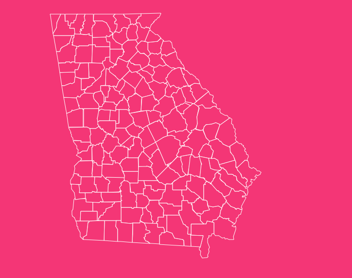
With 159 counties, Georgia has the second-highest number of counties in the United States, surpassed only by Texas.
For researchers, students, and travelers alike, navigating this complex patchwork of administrative divisions can be daunting.
Whether you are tracing genealogy, planning a road trip across the diverse landscapes of the Peach State, or conducting market research, understanding the layout of Georgia’s counties is essential.
How to Use the Interactive Map Tool
Hover Highlight
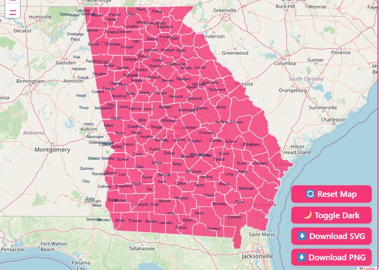
Simply move your mouse cursor over any specific county. The tool will instantly highlight the borders and display a tooltip with the county name and seat.
Zoom Functionality
Use the + and – buttons or your mouse scroll wheel to zoom in for a closer look at metropolitan areas like Atlanta, or zoom out to see the state’s relationship with neighboring Alabama, Florida, and the Carolinas.
Dark Mode Toggle
Late-night research? Switch the visual theme to dark mode to reduce eye strain and view the map with high-contrast borders.
Reset Button
If you’ve zoomed in too far or lost your orientation, hit the reset button to instantly return the map to its default statewide view.
Download Options
Need the map for a presentation or school project? You can easily download high-resolution versions. Choose “Blank Printable SVG” for a vector file you can edit, or “PNG” for a standard image file ready for documents.
A Historical Overview of County Formation
The “One Day’s Ride” Rule
A popular, albeit simplified, explanation for Georgia’s high county count is the “one day’s ride” concept.
In the 19th century, the idea was that any rural farmer should be able to travel by horse or mule to the county seat, conduct their legal business or vote, and return home before nightfall.
This necessitated smaller counties with centrally located county seats.
Political Power and the County Unit System
Beyond convenience, politics played a massive role. For much of the early to mid-20th century, Georgia operated under the “County Unit System.”
This unique electoral college-style system gave disproportionate political power to rural counties over populous urban centers.
This incentivized the creation and maintenance of many small, rural counties to maintain political leverage in the state legislature.
Although the Supreme Court struck down this system in 1963 (Gray v. Sanders), the 159 counties remain.
The Evolution of Boundaries
Georgia’s map didn’t start this way. The original colonial era saw parishes, which transitioned into counties after the American Revolution.
The number grew steadily as indigenous lands were acquired and distributed through land lotteries.
The total peaked at 161 counties before the Great Depression, when Campbell and Milton counties were merged into Fulton County to save money, bringing us to the current 159.
Geographical Overview of Georgia
Georgia is the largest state east of the Mississippi River in terms of land area, and its counties reflect a stunning geographical diversity. Understanding the physical layout helps contextualize the county map.
The Blue Ridge and Valley & Ridge (North)
Northern counties like Fannin, Union, and Rabun are defined by the Appalachian Mountains. These counties are rugged, known for outdoor tourism, and feature higher elevations.
The geography here historically limited large-scale plantation agriculture, leading to different economic developments compared to the south.
The Piedmont (Central)
This is the economic engine of the state. Counties like Fulton, Gwinnett, Cobb, and DeKalb sit on the rolling hills of the Piedmont plateau.
The “Fall Line”, a geological boundary where the hilly Piedmont meets the flat Coastal Plain, runs through counties like Bibb (Macon) and Muscogee (Columbus).
The Coastal Plain (South)
South of the Fall Line, the counties become larger and flatter. This region, including counties like Tift, Colquitt, and Coffee, is the agricultural heartland, famous for peanuts, cotton, and Vidalia onions (centered in Toombs and neighboring counties).
The Coast
The eastern edge involves counties like Chatham, Glynn, and Camden, which feature intricate marshlands, barrier islands, and historic port cities.
Important Georgia County Insights
With 159 options, where should you look? Here are some key counties that drive the state’s narrative.
Fulton County
The most populous county and home to the state capital, Atlanta. It is the cultural and economic center of the state.
Ware County
While not the most populous, it is the largest by land area. It contains a significant portion of the Okefenokee Swamp.
Clarke County
The smallest county by land area, yet it packs a punch as the home of the University of Georgia in Athens.
Chatham County
Home to Savannah, the oldest city in Georgia. It represents the historical coastal roots of the state.
Gwinnett County
Notable for being one of the most diverse counties in the Southeast, reflecting rapid demographic shifts in the metro Atlanta area.
The Importance of County Data
Why does this map matter? In Georgia, the county is the primary unit of local government. Unlike states with strong township systems, Georgia counties handle:
- Law Enforcement: The Sheriff is a constitutional officer with significant power in every county.
- School Systems: With few exceptions (like city school districts), school systems are organized at the county level.
- Taxation: Property taxes and vehicle tags are processed through the County Tax Commissioner.
- Elections: Voting precincts and administration are handled by county boards of elections.
For businesses, understanding county lines is crucial for tax compliance and zoning. For residents, it dictates where your children go to school and who represents you in the state legislature.
Complete List of Georgia Counties
Below is a comprehensive table of all 159 counties, including their Federal Information Processing Standards (FIPS) code, county seat, and the year they were established.
| County Name | FIPS Code | County Seat | Established |
| Appling | 001 | Baxley | 1818 |
| Atkinson | 003 | Pearson | 1917 |
| Bacon | 005 | Alma | 1914 |
| Baker | 007 | Newton | 1825 |
| Baldwin | 009 | Milledgeville | 1803 |
| Banks | 011 | Homer | 1858 |
| Barrow | 013 | Winder | 1914 |
| Bartow | 015 | Cartersville | 1832 |
| Ben Hill | 017 | Fitzgerald | 1906 |
| Berrien | 019 | Nashville | 1856 |
| Bibb | 021 | Macon | 1822 |
| Bleckley | 023 | Cochran | 1912 |
| Brantley | 025 | Nahunta | 1920 |
| Brooks | 027 | Quitman | 1858 |
| Bryan | 029 | Pembroke | 1793 |
| Bulloch | 031 | Statesboro | 1796 |
| Burke | 033 | Waynesboro | 1777 |
| Butts | 035 | Jackson | 1825 |
| Calhoun | 037 | Morgan | 1854 |
| Camden | 039 | Woodbine | 1777 |
| Candler | 043 | Metter | 1914 |
| Carroll | 045 | Carrollton | 1826 |
| Catoosa | 047 | Ringgold | 1853 |
| Charlton | 049 | Folkston | 1854 |
| Chatham | 051 | Savannah | 1777 |
| Chattahoochee | 053 | Cusseta | 1854 |
| Chattooga | 055 | Summerville | 1838 |
| Cherokee | 057 | Canton | 1831 |
| Clarke | 059 | Athens | 1801 |
| Clay | 061 | Fort Gaines | 1854 |
| Clayton | 063 | Jonesboro | 1858 |
| Clinch | 065 | Homerville | 1850 |
| Cobb | 067 | Marietta | 1832 |
| Coffee | 069 | Douglas | 1854 |
| Colquitt | 071 | Moultrie | 1856 |
| Columbia | 073 | Appling | 1790 |
| Cook | 075 | Adel | 1918 |
| Coweta | 077 | Newnan | 1826 |
| Crawford | 079 | Knoxville | 1822 |
| Crisp | 081 | Cordele | 1905 |
| Dade | 083 | Trenton | 1837 |
| Dawson | 085 | Dawsonville | 1857 |
| Decatur | 087 | Bainbridge | 1823 |
| DeKalb | 089 | Decatur | 1822 |
| Dodge | 091 | Eastman | 1870 |
| Dooly | 093 | Vienna | 1821 |
| Dougherty | 095 | Albany | 1853 |
| Douglas | 097 | Douglasville | 1870 |
| Early | 099 | Blakely | 1818 |
| Echols | 101 | Statenville | 1858 |
| Effingham | 103 | Springfield | 1777 |
| Elbert | 105 | Elberton | 1790 |
| Emanuel | 107 | Swainsboro | 1812 |
| Evans | 109 | Claxton | 1914 |
| Fannin | 111 | Blue Ridge | 1854 |
| Fayette | 113 | Fayetteville | 1821 |
| Floyd | 115 | Rome | 1832 |
| Forsyth | 117 | Cumming | 1832 |
| Franklin | 119 | Carnesville | 1784 |
| Fulton | 121 | Atlanta | 1853 |
| Gilmer | 123 | Ellijay | 1832 |
| Glascock | 125 | Gibson | 1857 |
| Glynn | 127 | Brunswick | 1777 |
| Gordon | 129 | Calhoun | 1850 |
| Grady | 131 | Cairo | 1905 |
| Greene | 133 | Greensboro | 1786 |
| Gwinnett | 135 | Lawrenceville | 1818 |
| Habersham | 137 | Clarkesville | 1818 |
| Hall | 139 | Gainesville | 1818 |
| Hancock | 141 | Sparta | 1793 |
| Haralson | 143 | Buchanan | 1856 |
| Harris | 145 | Hamilton | 1827 |
| Hart | 147 | Hartwell | 1853 |
| Heard | 149 | Franklin | 1830 |
| Henry | 151 | McDonough | 1821 |
| Houston | 153 | Perry | 1821 |
| Irwin | 155 | Ocilla | 1818 |
| Jackson | 157 | Jefferson | 1796 |
| Jasper | 159 | Monticello | 1807 |
| Jeff Davis | 161 | Hazlehurst | 1905 |
| Jefferson | 163 | Louisville | 1796 |
| Jenkins | 165 | Millen | 1905 |
| Johnson | 167 | Wrightsville | 1858 |
| Jones | 169 | Gray | 1807 |
| Lamar | 171 | Barnesville | 1920 |
| Lanier | 173 | Lakeland | 1920 |
| Laurens | 175 | Dublin | 1807 |
| Lee | 177 | Leesburg | 1826 |
| Liberty | 179 | Hinesville | 1777 |
| Lincoln | 181 | Lincolnton | 1796 |
| Long | 183 | Ludowici | 1920 |
| Lowndes | 185 | Valdosta | 1825 |
| Lumpkin | 187 | Dahlonega | 1832 |
| Macon | 193 | Oglethorpe | 1837 |
| Madison | 195 | Danielsville | 1811 |
| Marion | 197 | Buena Vista | 1827 |
| McDuffie | 189 | Thomson | 1870 |
| McIntosh | 191 | Darien | 1793 |
| Meriwether | 199 | Greenville | 1827 |
| Miller | 201 | Colquitt | 1856 |
| Mitchell | 205 | Camilla | 1857 |
| Monroe | 207 | Forsyth | 1821 |
| Montgomery | 209 | Mount Vernon | 1793 |
| Morgan | 211 | Madison | 1807 |
| Murray | 213 | Chatsworth | 1832 |
| Muscogee | 215 | Columbus | 1826 |
| Newton | 217 | Covington | 1821 |
| Oconee | 219 | Watkinsville | 1875 |
| Oglethorpe | 221 | Lexington | 1793 |
| Paulding | 223 | Dallas | 1832 |
| Peach | 225 | Fort Valley | 1924 |
| Pickens | 227 | Jasper | 1853 |
| Pierce | 229 | Blackshear | 1857 |
| Pike | 231 | Zebulon | 1822 |
| Polk | 233 | Cedartown | 1851 |
| Pulaski | 235 | Hawkinsville | 1808 |
| Putnam | 237 | Eatonton | 1807 |
| Quitman | 239 | Georgetown | 1858 |
| Rabun | 241 | Clayton | 1819 |
| Randolph | 243 | Cuthbert | 1828 |
| Richmond | 245 | Augusta | 1777 |
| Rockdale | 247 | Conyers | 1870 |
| Schley | 249 | Ellaville | 1857 |
| Screven | 251 | Sylvania | 1793 |
| Seminole | 253 | Donalsonville | 1920 |
| Spalding | 255 | Griffin | 1851 |
| Stephens | 257 | Toccoa | 1905 |
| Stewart | 259 | Lumpkin | 1830 |
| Sumter | 261 | Americus | 1831 |
| Talbot | 263 | Talbotton | 1827 |
| Taliaferro | 265 | Crawfordville | 1825 |
| Tattnall | 267 | Reidsville | 1801 |
| Taylor | 269 | Butler | 1852 |
| Telfair | 271 | McRae-Helena | 1807 |
| Terrell | 273 | Dawson | 1856 |
| Thomas | 275 | Thomasville | 1825 |
| Tift | 277 | Tifton | 1905 |
| Toombs | 279 | Lyons | 1905 |
| Towns | 281 | Hiawassee | 1856 |
| Treutlen | 283 | Soperton | 1917 |
| Troup | 285 | LaGrange | 1826 |
| Turner | 287 | Ashburn | 1905 |
| Twiggs | 289 | Jeffersonville | 1809 |
| Union | 291 | Blairsville | 1832 |
| Upson | 293 | Thomaston | 1824 |
| Walker | 295 | LaFayette | 1833 |
| Walton | 297 | Monroe | 1818 |
| Ware | 299 | Waycross | 1824 |
| Warren | 301 | Warrenton | 1793 |
| Washington | 303 | Sandersville | 1784 |
| Wayne | 305 | Jesup | 1803 |
| Webster | 307 | Preston | 1853 |
| Wheeler | 309 | Alamo | 1912 |
| White | 311 | Cleveland | 1857 |
| Whitfield | 313 | Dalton | 1851 |
| Wilcox | 315 | Abbeville | 1857 |
| Wilkes | 317 | Washington | 1777 |
| Wilkinson | 319 | Irwinton | 1803 |
| Worth | 321 | Sylvester | 1853 |
Frequently Asked Questions
How many counties are there in Georgia?
Georgia has 159 counties.
What is the largest county in Georgia by size?
Ware County is the largest county by land area, spanning approximately 903 square miles. It is located in the southeast portion of the state and contains much of the Okefenokee National Wildlife Refuge.
Which Georgia county has the highest population?
Fulton County is the most populous, home to over 1 million residents. It contains the majority of the City of Atlanta and serves as the core of the metropolitan area.
What is the smallest county in Georgia?
Clarke County is the smallest by land area, covering only about 121 square miles. Despite its size, it is densely populated due to the presence of the University of Georgia.
What was the last county formed in Georgia?
Peach County was the last county formed, established in 1924. It was carved out of parts of Houston and Macon counties.
Are there any consolidated city-county governments in Georgia?
Yes, there are several. Notable examples include Athens-Clarke County, Augusta-Richmond County, Columbus-Muscogee County, and Macon-Bibb County.
In these areas, the city and county governments have merged into a unified jurisdiction.
What are the “Coastal Counties” of Georgia?
There are six counties generally recognized as the immediate coast: Chatham (Savannah), Bryan, Liberty, McIntosh, Glynn (Brunswick/St. Simons), and Camden. These counties border the Atlantic Ocean.
Which county seat is the oldest?
Savannah, the seat of Chatham County, is the oldest city in Georgia, founded in 1733. However, regarding county formation, eight counties were created in 1777 under the state’s first constitution, including Chatham.
How do I find property lines on the Georgia counties map?
While a general county map shows jurisdiction boundaries, finding specific property lines usually requires accessing the GIS (Geographic Information System) map of the specific county tax assessor’s office.
What is the “Black Belt” regarding Georgia counties?
The “Black Belt” refers to a geological region of dark, fertile soil across the central southern US.
In Georgia, it also correlates with a band of counties that historically had high cotton production and currently have high percentages of African American residents.
Start Mapping Your Project Today
The Georgia counties map is more than just lines on a page; it is a reflection of centuries of history, politics, and geology.
We hope this guide has filled the gaps left by other resources, providing you with both the “big picture” and the granular details.
Ready to dive deeper? Scroll back up to use our interactive tool, download the high-resolution SVG for your presentation, or bookmark this page for your next research project.