From the emerald waters of the Panhandle to the bustling streets of Miami-Dade, Florida is a state of diverse landscapes and vibrant communities.
Navigating the Sunshine State requires more than just a GPS; it requires a deep understanding of its political and geographical divisions.
Whether you are a real estate investor, a film scout, a logistics manager, or a student, understanding the layout of Florida’s 67 counties is essential.
Florida county maps serve as the backbone for various industries, offering critical insights into jurisdiction, demographics, and infrastructure.
Unlike many other states, Florida’s county governments play a massive role in local administration, making the “county line” a significant boundary for laws, schools, and taxes.
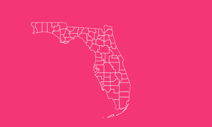
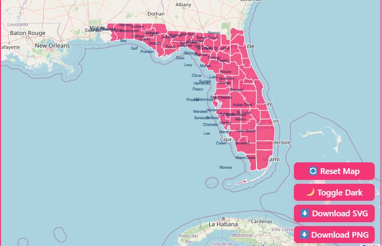
Interactive Map of Florida: How to Use the Tool on This Page
Hover & Highlight
Simply move your mouse over any county to see its name and boundary highlighted instantly. This feature is perfect for quickly identifying specific regions without clicking.
Zoom In & Out
Use the + and – buttons located in the corner of the map to focus on dense areas like the Tampa Bay region or zoom out for a statewide perspective.
Dark Mode Toggle
Working late? Switch the map interface to Dark Mode using the toggle button to reduce eye strain and improve visibility of neon map layers.
Reset Button
If you have applied too many filters or zoomed in too far, hit the Reset button to return the map to its default statewide view.
Download Options
Need a hard copy? You can download the current map view in multiple formats:
- Blank Printable: Ideal for classroom quizzes or sketching.
- SVG (Scalable Vector Graphics): Perfect for graphic designers who need to edit the map in software like Adobe Illustrator.
- PNG: A high-resolution image file ready for presentations and reports.
A Geographical Overview of Florida
Florida is a unique geographical entity in the United States, acting as a bridge between the temperate north and the tropical Caribbean.
The state is generally divided into three main geographical regions, each with distinct county clusters:
The Panhandle
This northwestern strip is known for its Southern charm and pine forests.
Counties here, such as Escambia and Leon (home to the capital, Tallahassee), are culturally and geographically distinct from the south.
The Peninsula
This makes up the bulk of the state. Central Florida counties like Orange and Polk are hubs for tourism and agriculture, characterized by rolling hills and thousands of lakes.
The Keys
Extending from the southern tip of the peninsula, Monroe County encompasses the Florida Keys, a coral cay archipelago that offers a tropical maritime environment unlike anywhere else in the continental U.S.
Historical Overview of County Formation
Understanding the Florida county map requires a look back in time.
When Florida became a United States territory in 1821, there were only two counties: Escambia to the west and St. Johns to the east. The Suwannee River served as the dividing line between them.
Over the next century, as the population grew and moved southward, these massive territories were carved into smaller political units.
The process of dividing counties continued well into the 20th century to accommodate booming populations and the need for more localized governance.
Today, the map is stabilized at 67 counties, ranging from the historic giants of the north to the densely populated powerhouses of the south.
The Importance of County Data
Why does county-level data matter so much in Florida?
Real Estate & Development
Property taxes, zoning laws, and school districts are determined at the county level. A map helps investors pinpoint jurisdiction lines that can affect property value.
Emergency Management
Florida is prone to hurricanes. Evacuation zones and emergency shelters are organized by county. Knowing which county you are in and your proximity to the coast is a matter of safety.
Economic Analysis
Businesses use county data to analyze labor markets. For instance, the economic drivers in tourist-heavy Osceola County differ vastly from the agricultural focus of Hendry County.
Important Florida County Insights
Largest County by Area
Palm Beach County is one of the largest by land area, dominating the southeastern coast.
Largest County by Population
Miami-Dade County is the most populous, serving as a major international hub for finance and culture.
Smallest County
Union County is the smallest by land area, tucked away in the northern part of the state.
Most Coastal Counties
A significant portion of Florida’s 67 counties border either the Atlantic Ocean or the Gulf of Mexico, highlighting the state’s reliance on the blue economy.
Comprehensive List of Florida Counties
Below is a reference table containing key data for all 67 Florida counties.
The “FIPS Code” is a standard identifier used by the federal government (and displayed in FDOT datasets), and the “County Seat” is the administrative center of the county.
| County Name | FIPS Code (Last 3 Digits) | County Seat |
| Alachua | 001 | Gainesville |
| Baker | 003 | Macclenny |
| Bay | 005 | Panama City |
| Bradford | 007 | Starke |
| Brevard | 009 | Titusville |
| Broward | 011 | Fort Lauderdale |
| Calhoun | 013 | Blountstown |
| Charlotte | 015 | Punta Gorda |
| Citrus | 017 | Inverness |
| Clay | 019 | Green Cove Springs |
| Collier | 021 | Naples |
| Columbia | 023 | Lake City |
| DeSoto | 027 | Arcadia |
| Dixie | 029 | Cross City |
| Duval | 031 | Jacksonville |
| Escambia | 033 | Pensacola |
| Flagler | 035 | Bunnell |
| Franklin | 037 | Apalachicola |
| Gadsden | 039 | Quincy |
| Gilchrist | 041 | Trenton |
| Glades | 043 | Moore Haven |
| Gulf | 045 | Port St. Joe |
| Hamilton | 047 | Jasper |
| Hardee | 049 | Wauchula |
| Hendry | 051 | LaBelle |
| Hernando | 053 | Brooksville |
| Highlands | 055 | Sebring |
| Hillsborough | 057 | Tampa |
| Holmes | 059 | Bonifay |
| Indian River | 061 | Vero Beach |
| Jackson | 063 | Marianna |
| Jefferson | 065 | Monticello |
| Lafayette | 067 | Mayo |
| Lake | 069 | Tavares |
| Lee | 071 | Fort Myers |
| Leon | 073 | Tallahassee |
| Levy | 075 | Bronson |
| Liberty | 077 | Bristol |
| Madison | 079 | Madison |
| Manatee | 081 | Bradenton |
| Marion | 083 | Ocala |
| Martin | 085 | Stuart |
| Miami-Dade | 086 | Miami |
| Monroe | 087 | Key West |
| Nassau | 089 | Fernandina Beach |
| Okaloosa | 091 | Crestview |
| Okeechobee | 093 | Okeechobee |
| Orange | 095 | Orlando |
| Osceola | 097 | Kissimmee |
| Palm Beach | 099 | West Palm Beach |
| Pasco | 101 | Dade City |
| Pinellas | 103 | Clearwater |
| Polk | 105 | Bartow |
| Putnam | 107 | Palatka |
| St. Johns | 109 | St. Augustine |
| St. Lucie | 111 | Fort Pierce |
| Santa Rosa | 113 | Milton |
| Sarasota | 115 | Sarasota |
| Seminole | 117 | Sanford |
| Sumter | 119 | Bushnell |
| Suwannee | 121 | Live Oak |
| Taylor | 123 | Perry |
| Union | 125 | Lake Butler |
| Volusia | 127 | DeLand |
| Wakulla | 129 | Crawfordville |
| Walton | 131 | De Funiak Springs |
| Washington | 133 | Chipley |
(Note: FIPS codes are derived from the standard Federal Information Processing Standards used in FDOT datasets. County Seats are sourced from geological survey data.)
Specialized Uses for Florida Maps
Beyond general geography, Florida county maps are utilized for specific professional applications ranging from Hollywood productions to highway maintenance.
Maps for Film and Media
Florida is a prime location for film and television production. From the beaches of Miami Vice to the swamps of the Everglades, the state offers diverse backdrops.
Film Offices
Florida has a network of over 60 local film offices. A county map is crucial for scouts to identify which local film commission presides over a specific location.
Permitting
Permitting requirements vary by county. Filmmakers use these maps to ensure they are contacting the correct jurisdiction for road closures or pyrotechnic permits.
Resource
The Florida Office of Film and Entertainment facilitates state-wide location searches, helping productions navigate county lines to find the perfect shot.
Transportation and District Management
The Florida Department of Transportation (FDOT) relies heavily on county boundaries to manage the state’s vast infrastructure.
District Divisions
FDOT divides the state’s counties into seven districts. For example, District 1 includes counties like Polk and Manatee, while District 6 comprises Miami-Dade and Monroe.
Data Maintenance
FDOT maintains precise GIS data on county boundaries to ensure accurate funding allocation and road maintenance schedules.
This data includes specific “FDOT County Codes” which differ slightly from federal FIPS codes, used internally for logistics.
Educational and Outline Maps
For teachers and students, outline maps are an invaluable resource. The Florida Center for Instructional Technology (FCIT) provides simplified maps perfect for the classroom.
Cities Labeled vs. Unlabeled
These maps are available in two main formats.
“Cities Labeled” maps are great for studying major population centers, while “Cities Not Labeled” versions act as excellent testing tools for geography quizzes.
Visual Learning
Using an outline map helps students visualize the sheer size of the state and the density of counties in the north versus the south.
Frequently Asked Questions
How many counties are in Florida?
There are exactly 67 counties in the state of Florida.
Which Florida county has the largest population?
Miami-Dade County is the most populous, home to millions of residents and the city of Miami.
What was the first county in Florida?
When Florida became a territory in 1821, it was divided into two counties: Escambia and St. Johns.
Which county is home to Disney World?
The majority of the Walt Disney World Resort is located in Orange County, though parts extend into Osceola County.
How do I find my county’s property lines?
You can use the MapWise Viewer or Explorer to view detailed parcel data, which overlays property lines onto the county map.
What is a “County Seat”?
A county seat is the city or town that serves as the administrative capital of the county, housing the courthouse and local government offices.
Are Florida counties divided into districts?
Yes, for transportation purposes, FDOT groups counties into seven distinct districts to manage infrastructure more effectively.
Which county is the southernmost in the continental US?
Monroe County, which includes Key West, holds the distinction of being the southernmost point.
Start Exploring Today
Ready to dive deeper?
Don’t just read about it, see it for yourself. Click the button below to download your high-resolution Florida County Map and start exploring the Sunshine State today.
[Download Free Map].