If you look at a map of the United States, county lines usually represent distinct local governments with sheriffs, courts, and tax collectors.
Connecticut, however, does things differently. While the outline of the state is divided into eight historic counties that locals know by heart, the political reality is much more complex.
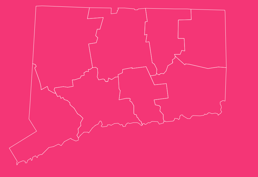
How to Use the Tool on This Page
Navigating the geography of Connecticut requires the right tools. Our interactive map offers several features designed to help you analyze county and COG data effectively:
- Hover Highlight: Simply move your cursor over any county or planning region to see its name and key statistics instantly.
- Zoom In & Out: Use the scroll wheel or the +/- buttons to focus on specific towns or get a statewide view.
- Dark Mode Toggle: Switch between light and dark themes for easier viewing in low-light environments.
- Reset Button: If you get lost in the details, hit the reset button to return to the default statewide view.
- Download Options: Need a hard copy? You can download blank printable SVG and PNG versions of the map for presentations or educational use.
Geographical Overview of Connecticut
Despite being the third-smallest state in the U.S., Connecticut packs a diverse geography into its 5,543 square miles.
Bordered by Rhode Island, Massachusetts, New York, and the Long Island Sound, the state transitions from coastal plains in the south to rolling hills and mountains in the northwest.
Understanding the county map is essential for navigating these regions.
The state is historically divided into eight counties, ranging from the bustling urban corridors of the southwest to the “Quiet Corner” in the northeast.
While these boundaries no longer dictate local government, they remain the standard for weather alerts, real estate listings, and general directions.
Historical Overview of County Formation
The history of Connecticut’s counties mirrors the history of the colony itself. The formation process began over 350 years ago and happened in two distinct waves.
The Original Four (1666)
On May 10, 1666, the Connecticut General Court established the first four counties:
- Fairfield
- Hartford
- New Haven
- New London
These original partitions were created to organize courts and jails for the growing colony.
The Colonial Expansion (1700s)
As settlers moved inland and populations grew, the need for more localized administration led to the carving out of new territories:
- Windham County was established in 1726 from eastern portions of Hartford and New London counties.
- Litchfield County followed in 1751, formed from the northwestern frontier lands.
Post-Independence Additions (1785)
The final changes occurred shortly after the American Revolution in 1785, bringing the total to eight:
- Middlesex County was created from parts of Hartford and New London.
- Tolland County was formed from parts of Hartford and Windham.
The Abolition of County Government
In a move that makes Connecticut unique among most U.S. states, the General Assembly completely abolished county governments in 1960.
Their powers were transferred to the state or the local towns. Since then, “county” in Connecticut has referred to a geographical region, not a political entity.
The Eight Counties of Connecticut: A Detailed Look
While the Census Bureau has moved on to new metrics, the eight historic counties remain the cultural backbone of the state. Here is a breakdown of each region.
Fairfield County
Located in the southwestern corner of the state, Fairfield County is the most populous region and serves as a major economic hub.
Known as the “Gold Coast” due to its wealth and proximity to New York City, it is home to major corporations and hedge funds.
- Key Towns: Bridgeport (largest city in the state), Stamford, Greenwich, Norwalk, Danbury.
- Vibe: Urban, wealthy, fast-paced, with heavy commuter ties to NYC.
Hartford County
Situated in the north-central part of the state, this county hosts the state capital. It is historically known as the “Insurance Capital of the World.”
The region features a mix of urban centers, suburban sprawl, and the fertile farmlands of the Connecticut River Valley.
- Key Towns: Hartford (state capital), New Britain, West Hartford, Manchester, Glastonbury.
- Vibe: Political, historical, and industrial.
Litchfield County
Covering the northwest corner, Litchfield is the largest county by land area but maintains a low population density.
It is famous for its rolling Litchfield Hills, covered bridges, and picturesque New England charm. It is a popular weekend getaway destination for New Yorkers.
- Key Towns: Torrington, New Milford, Litchfield, Kent.
- Vibe: Rural, scenic, artistic, and tranquil.
Middlesex County
Located in the south-central region, Middlesex is the smallest county by land area. It is defined by the Connecticut River, which bisects the county before emptying into the Long Island Sound.
- Key Towns: Middletown, Cromwell, Old Saybrook, East Hampton.
- Vibe: River/coastal mix, historic, residential.
New Haven County
Home to Yale University and famous pizza, New Haven County sits in the south-central coastal region.
It serves as a cultural and educational center for the state, balancing the gritty industrial history of Waterbury with the academic prestige of New Haven.
- Key Towns: New Haven, Waterbury, Meriden, Milford, Hamden.
- Vibe: Academic, coastal, culturally diverse.
New London County
This southeastern county is synonymous with the maritime industry. From the submarine base in Groton to the historic seaport of Mystic, the ocean dictates life here.
It is also the tourism capital of the state, hosting two of the largest casinos in the world.
- Key Towns: New London, Norwich, Groton, Stonington (Mystic).
- Vibe: Maritime, tourism-heavy, naval.
Tolland County
Tolland County is located in the northeastern part of the state. While it remains largely rural and suburban, it is dominated by the presence of the University of Connecticut (UConn) in Storrs (part of Mansfield).
- Key Towns: Vernon, Mansfield (Storrs), Tolland, Ellington.
- Vibe: College town energy surrounded by quiet rural towns.
Windham County
Known as the “Quiet Corner,” Windham County in the northeast is the least populous county. It retains a rural, agricultural feel that contrasts sharply with the bustle of Fairfield or Hartford.
- Key Towns: Willimantic (Windham), Putnam, Killingly, Plainfield.
- Vibe: Rural, agricultural, historic mill towns.
Important Connecticut County Insights
Understanding the data behind the geography helps contextualize the state’s layout.
Below is a breakdown of the eight historic counties, including their Federal Information Processing Standards (FIPS) codes, county seats (historical), and establishment dates.
Connecticut County Data Table
| County | FIPS Code | Historic Seat | Established. | Population (approx) | Area (sq mi) |
| Fairfield | 09-001 | Bridgeport | 1666 | 959,000 | 626 |
| Hartford | 09-003 | Hartford | 1666 | 896,000 | 736 |
| Litchfield | 09-005 | Litchfield | 1751 | 185,000 | 920 |
| Middlesex | 09-007 | Middletown | 1785 | 164,000 | 369 |
| New Haven | 09-009 | New Haven | 1666 | 863,000 | 606 |
| New London | 09-011 | New London | 1666 | 268,000 | 666 |
| Tolland | 09-013 | Rockville | 1785 | 150,000 | 410 |
| Windham | 09-015 | Willimantic | 1726 | 116,000 | 513 |
Key Takeaways:
- Largest by Population: Fairfield County.
- Largest by Area: Litchfield County.
- Smallest by Area: Middlesex County.
- Oldest: Fairfield, Hartford, New Haven, and New London (all 1666).
The Shift to Councils of Governments (COGs)
If you are looking for modern data on Connecticut, the map above tells only half the story.
Because Connecticut counties have had no government function since 1960, utilizing them for federal statistical data (like the Census) became increasingly inefficient.
Federal funding often relies on county-level data, but Connecticut’s counties didn’t reflect how the state actually functioned administratively.
To fix this, the state proposed a major change. In 2019, Connecticut recommended that the U.S. Census Bureau replace the eight historic counties with the state’s nine Councils of Governments (COGs) for statistical purposes.
The Timeline of Change:
- 2019: State recommends the shift.
- 2022: U.S. Census Bureau approves the proposal (June 6).
- 2023-2024: Full implementation of data reporting.
As of 2024, if you are looking at federal datasets, you will no longer see “Fairfield County.” Instead, you will see regions like the “Western Connecticut Council of Governments.”
Understanding the Nine COGs
These planning regions are groups of municipalities that work together on regional issues like transportation and land use. Unlike the old counties, these groups have active administrative functions.
Here are the nine new county-equivalents:
Capitol Region Council of Governments (CRCOG)
Covers the Hartford area and surrounding suburbs.
Western Connecticut Council of Governments (WestCOG)
Covers the southern part of the old Fairfield County and parts of Litchfield.
Naugatuck Valley Council of Governments (NVCOG)
Covers the Waterbury area and the Naugatuck Valley.
South Central Regional Council of Governments (SCRCOG)
Covers the Greater New Haven area.
Southeastern Connecticut Council of Governments (SECCOG)
Covers the New London and Norwich areas.
Northeastern Connecticut Council of Governments (NECCOG)
Covers the “Quiet Corner” (Windham/Putnam area).
Northwest Hills Council of Governments (NHCOG)
Covers the rural northwest (Litchfield Hills).
Lower Connecticut River Valley Council of Governments (RiverCOG)
Covers the mouth of the Connecticut River (Middlesex area).
Greater Bridgeport Council of Governments (MetroCOG)
Covers Bridgeport and immediate neighbors.
Practical Implications of the Change
Does this mean your address changes? No.
The shift to COGs is almost entirely administrative and statistical. Here is how it affects—and doesn’t affect residents:
Postal Addresses
You will still write “Fairfield County” or “New Haven County” in mail (if you include the county at all).
Weather Alerts
The National Weather Service still uses the historic county boundaries for storm watches and warnings.
Data Analysis
Researchers, grant writers, and urban planners must now use COG data rather than county data for federal applications.
Funding
This change aligns federal funding more closely with the local organizations (the COGs) that actually administer the programs, potentially bringing more efficiency to state planning.
The Importance of County Data
Why does this map matter if there is no county government? Despite the lack of a sheriff or a county executive, data at this level is crucial for:
Demographics
Understanding where population growth is occurring (e.g., the influx into Fairfield County vs. stability in Windham).
Real Estate
The housing market is heavily segmented by these boundaries. “Litchfield County farmhouse” implies a specific aesthetic and price point.
Public Health
During health crises, data is often visualized by counties to track localized outbreaks.
Identity
Residents strongly identify with their county. It provides a sense of place in a state with 169 distinct towns.
Frequently Asked Questions (FAQ)
How many counties are in Connecticut?
Historically and geographically, there are eight counties. However, for federal statistical purposes (like the Census), the state is now divided into nine planning regions (COGs).
Does Connecticut have county governments?
No. Connecticut abolished all county governments in 1960. There are no county taxes, no county courts, and no county sheriffs.
Which Connecticut county is the largest by size?
Litchfield County is the largest by land area, covering roughly 920 square miles.
Which Connecticut county has the highest population?
Fairfield County is the most populous, with over 950,000 residents, driven largely by its proximity to New York City.
Why did Connecticut switch from counties to COGs for data?
The switch allows for better alignment between federal data and the actual local organizations (Councils of Governments) that handle regional planning, improving access to federal funding.
Will my mailing address change because of the COG switch?
No. The United States Postal Service (USPS) does not require counties for addressing, and this change does not affect town names or zip codes.
What is the “Quiet Corner”?
This nickname refers to Windham County in the northeast, known for its rural atmosphere, lack of major highways, and antique shops.
Which county is the state capital located in?
Hartford, the state capital, is located in Hartford County.
When were the original counties established?
The first four counties, Fairfield, Hartford, New Haven, and New London were established in 1666.
The Evolving Landscape of Connecticut’s Geography
Whether you are a researcher needing the new COG boundaries or a resident looking for the historic Litchfield Hills, understanding this map is key.
Ready to explore the state in detail?
[Download Free County Map].