Arkansas, famously known as the Natural State, offers a stunning tapestry of mountains, valleys, dense forests, and fertile plains.
From the rugged Ozarks to the rich Mississippi River Delta, its diverse geography is as captivating as its history. To truly appreciate the breadth and organization of this remarkable state, a good map is indispensable.
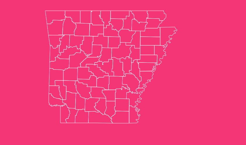
Specifically, an Arkansas state map with counties provides the framework for understanding its administrative divisions, historical evolution, and unique local character.
How to Use the Interactive Map Tool on This Page
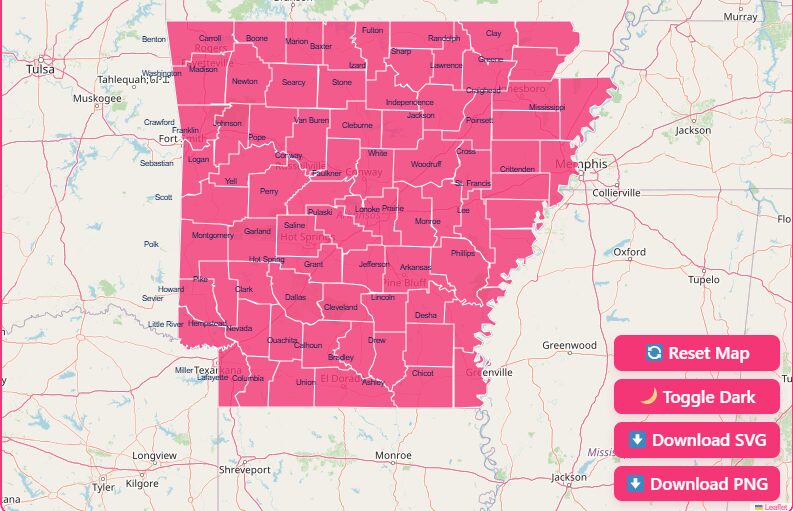
This page features a powerful interactive map of Arkansas designed to help you explore the state’s 75 counties with ease. Here’s a quick guide to its features:
Hover and Highlight
Simply move your cursor over any county on the map, and it will be highlighted. This allows you to quickly identify county borders and locations.
Zoom In and Out
Use the “+” and “-” buttons on the map or your mouse’s scroll wheel to get a closer look at specific counties or a broader view of the entire state.
Dark Mode Toggle
Prefer a different look? Switch to dark mode for a viewing experience that’s easier on the eyes, especially in low-light conditions.
Reset Button
If you’ve zoomed or panned away, click the reset button to return the map to its original, centered view.
Download Options
Need a map for offline use? You have the option to download a blank, printable version in both SVG and PNG formats, perfect for projects, reports, or travel planning.
A Historical Overview of Arkansas Maps
The maps of Arkansas we see today are the result of centuries of exploration, settlement, and technological advancement. Their history tells the story of the state itself.
Early Exploration and Mapping
The story of Arkansas’s maps begins long before it became a state. Early European exploration was driven by the French, who sought to expand their influence in the New World.
In 1686, Henri de Tonti established the Arkansas Post, the first European settlement in the lower Mississippi River Valley.
This trading post became a crucial point on early maps, marking a known location in a largely uncharted wilderness. The Louisiana Purchase of 1803 was a pivotal moment.
The United States acquired a vast territory from France, including what is now Arkansas, sparking a new wave of American exploration and a pressing need for accurate maps to understand and govern the new land.
Territorial and Statehood Maps
After the Louisiana Purchase, Arkansas was designated as a territory in 1819.
Early territorial maps were often rudimentary, but they were essential for defining boundaries and facilitating settlement.
The Pine Bluff Library hosts an extensive digital collection of these early maps, including one from 1822 that shows the Arkansas Territory in its infancy.
When Arkansas achieved statehood on June 15, 1836, becoming the 25th state to join the Union, the demand for more detailed and accurate maps grew.
Statehood required precise delineation of county lines, property plots, and transportation routes.
A Geographical Overview of Arkansas
Arkansas boasts a diverse landscape that is typically divided into six distinct geographical regions, each contributing to the unique character of its counties.
Ozark Plateau
Located in the northwestern part of the state, this region is characterized by its rugged, deeply dissected plateaus.
The Boston Mountains, a subrange of the Ozarks, contain some of the state’s highest peaks and most dramatic scenery.
Arkansas River Valley
This 40-mile-wide basin separates the Ozark and Ouachita Mountains. Its fertile soil and relatively flat terrain have made it a hub for agriculture and population centers.
Ouachita Mountains
Running east to west in west-central Arkansas, this range is known for its parallel ridges and valleys. It is home to Mount Magazine, the state’s highest point at 2,753 feet.
West Gulf Coastal Plain
Covering the southern part of the state, this area features rolling hills, dense pine forests, and significant petroleum and natural gas deposits.
Mississippi Alluvial Plain (The Delta)
The eastern portion of Arkansas is defined by the flat, fertile lowlands of the Mississippi River Delta. This is the state’s primary agricultural region, renowned for its cotton, rice, and soybean production.
Crowley’s Ridge
A unique geological formation, this narrow, low-lying ridge rises up to 550 feet above the surrounding Delta. It runs for about 200 miles from southeastern Missouri into eastern Arkansas.
Understanding Arkansas’s 75 Counties
Arkansas is divided into 75 counties, which serve as the primary administrative units of local government.
They are responsible for a wide range of functions, including law enforcement, court administration, road maintenance, and election oversight.
List of Arkansas Counties
The table below provides a comprehensive list of all 75 Arkansas counties, along with their FIPS code, county seat(s), and the year they were established.
| County Name | FIPS Code | County Seat(s) | Established |
| Arkansas | 05001 | DeWitt, Stuttgart | 1813 |
| Ashley | 05003 | Hamburg | 1848 |
| Baxter | 05005 | Mountain Home | 1873 |
| Benton | 05007 | Bentonville | 1836 |
| Boone | 05009 | Harrison | 1869 |
| Bradley | 05011 | Warren | 1840 |
| Calhoun | 05013 | Hampton | 1850 |
| Carroll | 05015 | Berryville, Eureka Springs | 1833 |
| Chicot | 05017 | Lake Village | 1823 |
| Clark | 05019 | Arkadelphia | 1818 |
| Clay | 05021 | Corning, Piggott | 1873 |
| Cleburne | 05023 | Heber Springs | 1883 |
| Cleveland | 05025 | Rison | 1873 |
| Columbia | 05027 | Magnolia | 1852 |
| Conway | 05029 | Morrilton | 1825 |
| Craighead | 05031 | Jonesboro, Lake City | 1859 |
| Crawford | 05033 | Van Buren | 1820 |
| Crittenden | 05035 | Marion | 1825 |
| Cross | 05037 | Wynne | 1862 |
| Dallas | 05039 | Fordyce | 1845 |
| Desha | 05041 | Arkansas City | 1838 |
| Drew | 05043 | Monticello | 1846 |
| Faulkner | 05045 | Conway | 1873 |
| Franklin | 05047 | Charleston, Ozark | 1837 |
| Fulton | 05049 | Salem | 1842 |
| Garland | 05051 | Hot Springs | 1873 |
| Grant | 05053 | Sheridan | 1869 |
| Greene | 05055 | Paragould | 1833 |
| Hempstead | 05057 | Hope | 1818 |
| Hot Spring | 05059 | Malvern | 1829 |
| Howard | 05061 | Nashville | 1873 |
| Independence | 05063 | Batesville | 1820 |
| Izard | 05065 | Melbourne | 1825 |
| Jackson | 05067 | Newport | 1829 |
| Jefferson | 05069 | Pine Bluff | 1829 |
| Johnson | 05071 | Clarksville | 1833 |
| Lafayette | 05073 | Lewisville | 1827 |
| Lawrence | 05075 | Walnut Ridge | 1815 |
| Lee | 05077 | Marianna | 1873 |
| Lincoln | 05079 | Star City | 1871 |
| Little River | 05081 | Ashdown | 1867 |
| Logan | 05083 | Booneville, Paris | 1871 |
| Lonoke | 05085 | Lonoke | 1873 |
| Madison | 05087 | Huntsville | 1836 |
| Marion | 05089 | Yellville | 1836 |
| Miller | 05091 | Texarkana | 1820 |
| Mississippi | 05093 | Blytheville, Osceola | 1833 |
| Monroe | 05095 | Clarendon | 1829 |
| Montgomery | 05097 | Mount Ida | 1842 |
| Nevada | 05099 | Prescott | 1871 |
| Newton | 05101 | Jasper | 1842 |
| Ouachita | 05103 | Camden | 1842 |
| Perry | 05105 | Perryville | 1840 |
| Phillips | 05107 | Helena | 1820 |
| Pike | 05109 | Murfreesboro | 1833 |
| Poinsett | 05111 | Harrisburg | 1838 |
| Polk | 05113 | Mena | 1844 |
| Pope | 05115 | Russellville | 1829 |
| Prairie | 05117 | Des Arc, DeValls Bluff | 1846 |
| Pulaski | 05119 | Little Rock | 1818 |
| Randolph | 05121 | Pocahontas | 1835 |
| Saline | 05123 | Benton | 1835 |
| Scott | 05125 | Waldron | 1833 |
| Searcy | 05127 | Marshall | 1838 |
| Sebastian | 05129 | Fort Smith, Greenwood | 1851 |
| Sevier | 05131 | De Queen | 1828 |
| Sharp | 05133 | Ash Flat | 1868 |
| St. Francis | 05135 | Forrest City | 1827 |
| Stone | 05137 | Mountain View | 1873 |
| Union | 05139 | El Dorado | 1829 |
| Van Buren | 05141 | Clinton | 1833 |
| Washington | 05143 | Fayetteville | 1828 |
| White | 05145 | Searcy | 1835 |
| Woodruff | 05147 | Augusta | 1862 |
| Yell | 05149 | Danville, Dardanelle | 1840 |
What Are Some Important Arkansas County Insights?
- Most Populous: Pulaski County, home to the state capital Little Rock, is the most populous county.
- Largest by Area: Union County is the largest county by land area.
- Smallest by Area: Lafayette County is the smallest.
- Dual County Seats: Ten counties have two county seats, a historical relic from a time when travel across a county was difficult.
- Dry vs. Wet Counties: Arkansas has a mix of “wet” counties where alcohol sales are legal and “dry” counties where they are prohibited, a detail often important for travelers and residents.
What Are the Practical Uses of Arkansas County Maps?
County maps are more than just administrative tools; they are valuable resources for a variety of purposes.
Travel and Tourism
For tourists, a county map is essential for planning road trips.
The Arkansas Department of Transportation (ARDOT) provides excellent tourist maps that highlight scenic byways, state parks, and points of interest within each county.
Genealogy and Historical Research
Historians and genealogists rely on historical county maps to trace family histories and understand settlement patterns.
County boundaries have shifted over time, and these maps provide crucial context for locating records.
Real Estate and Property Research
County maps are indispensable for real estate. They show property lines, zoning regulations, and land use information, which is critical for developers, buyers, and sellers.
Your Guide to Arkansas
Whether you’re planning a trip, researching your family’s past, or simply curious about the state’s layout, the Arkansas state map with counties is your gateway to discovery.
Frequently Asked Questions
How many counties are in Arkansas?
Arkansas is divided into 75 counties, each with its own local government and county seat.
Which Arkansas county is the largest by population?
Pulaski County is the most populous county in Arkansas. It includes the state capital, Little Rock, and is a major center for commerce, culture, and government.
Why do some Arkansas counties have two county seats?
Ten Arkansas counties have dual county seats.
This arrangement is a historical holdover from the 19th century when travel within a large county was difficult, and having two seats made government services more accessible to all residents.
What is the newest county in Arkansas?
Cleburne County, established in 1883, is the newest county in Arkansas.
Which Arkansas county is the largest by land area?
Union County, located in the southern part of the state, is the largest county by land area, covering approximately 1,039 square miles.
Which county is home to Hot Springs National Park?
Hot Springs National Park is located in Garland County. The city of Hot Springs serves as the county seat.
What is a “dry” county in Arkansas?
A “dry” county is one where the sale of alcoholic beverages is prohibited by law. Arkansas has a mix of wet and dry counties, and this information can be important for travelers.
What is a FIPS code?
A FIPS (Federal Information Processing Standard) code is a five-digit number that uniquely identifies counties and county equivalents in the United States.
The first two digits represent the state, and the last three identify the county within that state.