Arizona, known as the Grand Canyon State, is a land of stunning contrasts.
From the sun-scorched Sonoran Desert in the south to the pine-clad mountains of the Colorado Plateau in the north, its geography is as diverse as its history.
To truly understand Arizona, one must explore its 15 counties, each a unique piece of the state’s vibrant mosaic.
Geographical Overview of Arizona
Arizona’s landscape is famously divided into three major regions:
The Colorado Plateau
Covering the northern part of the state, this high-altitude region is home to the Grand Canyon, Humphrey’s Peak (the state’s highest point), and vast pine forests.
It’s characterized by deep canyons and dramatic mesas.
The Transition Zone
A mountainous belt running diagonally through the center of the state, this area features rugged ranges and valleys. It separates the high plateau from the low desert.
The Basin and Range Province
Encompassing the southern and western portions, this region is classic desert territory. It consists of isolated mountain ranges separated by wide, flat desert basins.
These distinct geographical zones have shaped the development, economy, and culture of Arizona’s counties.
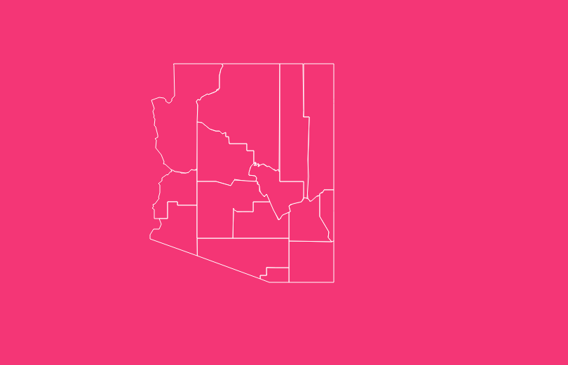
Arizona’s 15 Counties at a Glance
Each of Arizona’s 15 counties has its own government, county seat, and distinct identity. The table below provides a quick reference to essential information for each one.
| County Name | FIPS Code | County Seat | Established |
| Apache | 04001 | St. Johns | 1879 |
| Cochise | 04003 | Bisbee | 1881 |
| Coconino | 04005 | Flagstaff | 1891 |
| Gila | 04007 | Globe | 1881 |
| Graham | 04009 | Safford | 1881 |
| Greenlee | 04011 | Clifton | 1909 |
| La Paz | 04012 | Parker | 1983 |
| Maricopa | 04013 | Phoenix | 1871 |
| Mohave | 04015 | Kingman | 1864 |
| Navajo | 04017 | Holbrook | 1895 |
| Pima | 04019 | Tucson | 1864 |
| Pinal | 04021 | Florence | 1875 |
| Santa Cruz | 04023 | Nogales | 1899 |
| Yavapai | 04025 | Prescott | 1864 |
| Yuma | 04027 | Yuma | 1864 |
Historical Overview of County Formation
Arizona’s county map has evolved significantly since it was first established.
When the Arizona Territory was created in 1864, it was divided into four original counties: Mohave, Pima, Yavapai, and Yuma. These vast territories covered the entire state.
As the population grew and settlements expanded, these large counties were partitioned to create new ones.
Maricopa County was formed in 1871 from parts of Yavapai and Pima, centered around the growing agricultural community of Phoenix.
The late 19th century saw a boom in county creation, with Apache (1879), Cochise (1881), Gila (1881), Graham (1881), Coconino (1891), and Navajo (1895) all being carved out of existing territories.
Santa Cruz was established in 1899, and Greenlee in 1909.
The most recent addition is La Paz County, which was split from Yuma County in 1983, making it Arizona’s newest county.
This process of division reflects the state’s growth, from a sparsely populated territory to a thriving modern state.
An In-Depth Look at Each Arizona County
Let’s explore the unique characteristics of each of Arizona’s 15 counties.
Maricopa County
Location:
South-central Arizona.
Key City:
Phoenix (County Seat and State Capital).
Characteristics
As the state’s most populous county, Maricopa is the economic and political heart of Arizona. It’s home to a sprawling metropolitan area that includes Scottsdale, Tempe, and Mesa.
The county lies in the Sonoran Desert and is defined by its urban development and extensive canal system.
Pima County
- Location: Southern Arizona.
- Key City: Tucson (County Seat).
Characteristics
Pima County is Arizona’s second-most populous county. It boasts a rich cultural heritage, blending Native American, Spanish, and Anglo influences.
It is home to Saguaro National Park, Kitt Peak National Observatory, and the University of Arizona.
Pinal County
- Location: Central Arizona, between Phoenix and Tucson.
- Key City: Florence (County Seat).
Characteristics
Pinal is one of the fastest-growing counties in the U.S. It serves as a major transportation corridor and is known for its agriculture, particularly cotton.
Casa Grande Ruins National Monument is a key historical site.
Yavapai County
- Location: Central Arizona.
- Key City: Prescott (County Seat).
Characteristics
One of the original four counties, Yavapai has a rich history tied to mining and ranching. Prescott served as the original territorial capital.
The county features a diverse landscape, from the red rocks of Sedona to the mountains around Prescott.
Mohave County
- Location: Northwestern Arizona.
- Key City: Kingman (County Seat).
Characteristics
Another of the original four, Mohave County contains a significant portion of the Grand Canyon and the Lake Mead National Recreation Area.
It shares borders with Nevada and California and is a popular destination for tourism and recreation.
Yuma County
- Location: Southwestern Arizona.
- Key City: Yuma (County Seat).
Characteristics
Located along the Colorado River, Yuma County is one of the driest and sunniest places in the U.S. It’s a major agricultural center, producing most of the nation’s winter lettuce.
Its history is tied to the Yuma Crossing, a historic river crossing.
Coconino County
- Location: Northern Arizona.
- Key City: Flagstaff (County Seat).
Characteristics
Coconino is the second-largest county by land area in the contiguous United States. It’s home to the Grand Canyon National Park, the city of Flagstaff, and the San Francisco Peaks.
Much of the county is covered by ponderosa pine forests.
Apache County
- Location: Northeastern Arizona.
- Key City: St. Johns (County Seat).
Characteristics
Apache County encompasses a large portion of the Navajo Nation and the Fort Apache Indian Reservation.
It is known for its stunning natural landscapes, including the Petrified Forest National Park and the Painted Desert.
Navajo County
- Location: Northeastern Arizona.
- Key City: Holbrook (County Seat).
Characteristics
Named for the Navajo people, this county includes parts of the Navajo Nation, the Hopi Reservation, and the Fort Apache Indian Reservation.
It features a diverse landscape, from the forests of the Mogollon Rim to the desert lands of Monument Valley.
Cochise County
- Location: Southeastern Arizona.
- Key City: Bisbee (County Seat).
Characteristics
Steeped in Old West history, Cochise County was the scene of famous events involving Wyatt Earp and the OK Corral in Tombstone.
It’s also known for its “sky island” mountain ranges and growing wine industry.
Gila County
- Location: Central Arizona.
- Key City: Globe (County Seat).
Characteristics
Gila County is characterized by its rugged, mountainous terrain and deep canyons, including the Salt River Canyon. Its history is rooted in copper mining.
The Tonto Natural Bridge State Park is a major attraction.
Graham County
- Location: Southeastern Arizona.
- Key City: Safford (County Seat).
Characteristics
This county is home to Mount Graham, one of the highest peaks in southern Arizona and the site of an international observatory. Agriculture is a key part of its economy.
Santa Cruz County
- Location: Southern Arizona, bordering Mexico.
- Key City: Nogales (County Seat).
Characteristics
Arizona’s smallest county by area, Santa Cruz is a major port of entry from Mexico. It has a rich history tied to Spanish missions and ranching. The city of Nogales is split by the international border.
Greenlee County
- Location: Southeastern Arizona, on the New Mexico border.
- Key City: Clifton (County Seat).
Characteristics
Greenlee is Arizona’s least populous county. Its economy is dominated by the Morenci Mine, one of the largest copper mines in the world. The landscape is rugged and mountainous.
La Paz County
- Location: Western Arizona.
- Key City: Parker (County Seat).
Characteristics
Arizona’s newest county, La Paz, was created in 1983. It borders the Colorado River and is a popular destination for water sports and recreation.
Quartzsite is a famous winter destination for RVers.
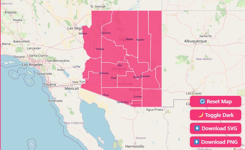
How to Use Our Interactive Arizona County Map
This page features an interactive map designed to help you explore Arizona’s counties with ease. Here’s how to use its features to get the most out of your exploration.
Hover and Highlight
Simply move your cursor over any county on the map. The county will be highlighted, and its name will appear, making it easy to identify each region.
Zoom In and Out
Use the scroll wheel on your mouse or the zoom buttons on the map to get a closer look at county borders, cities, and geographical features.
Dark Mode Toggle
Prefer a different look? Switch to dark mode for better visibility in low-light conditions or simply for a different aesthetic.
Reset Button
If you’ve zoomed in or moved the map around, click the reset button to return to the original statewide view.
Download Options (Blank SVG & PNG)
Need a printable map for a project or presentation? You can download high-quality blank maps of Arizona in both SVG and PNG formats. These are perfect for educational use, reports, or personal projects.
The Importance of County Data
Arizona county maps are more than just geographical tools; they are gateways to a wealth of data. Government agencies, businesses, and researchers use county-level data for:
- Urban Planning: Understanding population density and growth patterns.
- Economic Development: Analyzing local economies and identifying opportunities.
- Emergency Management: Coordinating resources and response efforts.
- Genealogy and History: Tracing family histories and understanding historical settlement patterns.
- Travel and Tourism: Planning routes and discovering regional attractions.
By using a county map, you can access and visualize this information in a meaningful context.
Get Your Free Arizona County Map
Ready to start exploring? A detailed county map is an indispensable tool. Whether you are planning a road trip, conducting research, or simply want to learn more about the Grand Canyon State, having a reliable map is the first step.
We offer a free, high-resolution Arizona state map with counties for you to download. Use it to chart your adventures and deepen your knowledge of Arizona’s diverse regions.
Frequently Asked Questions (FAQs)
What are the four original counties of Arizona?
The four original counties established in 1864 were Mohave, Pima, Yavapai, and Yuma.
What is the newest county in Arizona?
La Paz County is the newest, formed in 1983 after being split from Yuma County.
Which Arizona county is the largest by population?
Maricopa County is by far the most populous, containing the city of Phoenix and its surrounding suburbs.
Which Arizona county is the largest by land area?
Coconino County is the largest by land area, and it is the second-largest county in the contiguous United States.
Which Arizona county is the smallest?
Santa Cruz County, located on the border with Mexico, is the smallest county in Arizona by area.
Why are Arizona counties so large compared to eastern states?
Western states were sparsely populated when counties were formed, so larger territories were established to encompass existing settlements and allow for future growth.
How many Arizona counties border Mexico?
Four counties border Mexico: Yuma, Pima, Santa Cruz, and Cochise.
Where can I find demographic data for each county?
The U.S. Census Bureau is the primary source for detailed demographic data. The Arizona Office of Economic Opportunity also provides state-specific data at the county level.
Do any Arizona counties have a different time zone?
Yes, the Navajo Nation, which spans parts of Apache, Navajo, and Coconino counties, observes Daylight Saving Time,
while the rest of Arizona does not (with the exception of the Hopi Nation, which is surrounded by the Navajo Nation and also does not observe DST).
This creates a unique time zone situation in the northeastern part of the state.
Discover the Real Arizona
Use the tools and information here to plan your next journey, fuel your research, or simply satisfy your curiosity about the Grand Canyon State.